Withlacoochee Update (Pre-Milton) - 10/8/2024
Southwest Florida Water Management District sent this bulletin at 10/08/2024 12:15 PM EDTRiver, Lake, and Structure Conditions
With Hurricane Milton headed our way, I wanted to give you a quick update on river, lake and structure conditions. It is still too early to know exactly what the impacts will be to our area, so please take the necessary precautions to protect yourselves and your property.
Note: In the update below, I’ve included links to the USGS gauge conditions so you can keep an eye on what the river is doing in different areas.
Little Withlacoochee River (Sumter/Hernando Counties):
- The Little Withlacoochee River at US 301 is currently 4 feet lower than it’s peak on August 7th after Hurricane Debby.
- This is still relatively high, so substantial rain from Milton could cause the river to flood higher than it did after Debby.
- Upstream in the Green Swamp, water levels remain elevated from summer rains, with very little storage available to absorb the heavy rainfall that is forecast for this storm.
Withlacoochee River (Green Swamp to the Gulf of Mexico):
Overall, the Withlacoochee River is still high. It is currently predicted to reach an even higher flood stage than it did in August/September, based on forecasted rainfall from Hurricane Milton.
Green Swamp
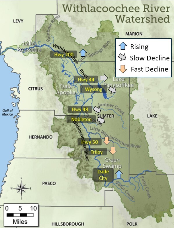
- The Withlacoochee River at SR471, in the middle of Green Swamp, has risen about a foot in the past week from recent rainfall.
- At the Dade City gauge on the west side of the Green Swamp, river levels are also starting to rise again from rainfall over the weekend.
- The many swamps, creeks, and wetlands in the Green Swamp remain saturated, so heavy rainfall from Hurricane Milton will cause much higher water levels downstream along the Withlacoochee River. River flows leaving the Green Swamp also remain high.
- There are no structures in the Green Swamp to hold back or divert any water and all frow from this region is natural.
Trilby and Ridge Manor
- The Withlacoochee River at Trilby (US301) has been dropping for the past few weeks and is currently 3 feet below its peak in August after Hurricane Debby.
- The National Weather Service is currently predicting Trilby to return to flood stage after Hurricane Milton and even peak higher than it did in August.
- Near Ridge Manor (SR50) the river has also been dropping in recent weeks and is also about 3 feet lower than its August peak.
- But like Trilby, it could reach flood stage in the coming days/weeks if the forecasted rainfall from Milton materializes.
Nobleton and Hwy 48
- Downstream at Nobleton (CR476), the Withlacoochee River has fallen about ½ foot over the past couple weeks and is down 1 foot from its peak in August.
- At Hwy 48 (between Floral City and Bushnell), river levels have finally fallen about ½ foot over the past week and are currently 0.8 feet below their August peak.
- At both Nobleton and Hwy 48, river levels remain elevated from wet season rainfall and the full effect from Milton won’t likely be seen until a couple weeks after the storm.
Hwy 44 and Hwy 200
- River levels at Hwy 44 also remain high and are only 0.8 feet lower than their peak in September.
- At Hwy 200 (Holder), the Withlacoochee River has only dropped about a foot since it peaked there in mid-September.
- The National Weather Service is currently predicting Hwy 200 will rise more than 2 feet from Hurricane Milton.
- This is an early prediction though, and residents should continue to monitor predictions because they will change before and after the storm.
- The peak flooding at Hwy 44 and 200 won’t likely occur until 2-4 weeks after Hurricane Milton passes.
Dunnellon and Lake Rousseau
- At Dunnellon (Hwy 41), the Withlacoochee River is finally back down near its normal level, but will likely return to minor flood stage several weeks after Hurricane Milton.
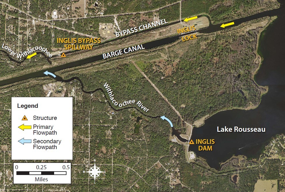
- On Lake Rousseau, the Inglis Dam, which was opened on August 3rd, remains open discharging excess flows to the Barge Canal.
- Lake Rousseau has once again been lowered in preparation of both storm surge and river flooding from Hurricane Milton.
- The Inglis Dam has no effect on river levels upstream near Hwy 200. Any flooding in that area, or farther upstream, is caused by natural river conditions.
Lower Withlacoochee River
- The Inglis Bypass Spillway also remains fully open, discharging high flows to the Lower Withlacoochee River.
- By lowering Lake Rousseau ahead of the storm, the Bypass Spillway can be closed during the storm surge/high tide cycles to prevent additional flooding on the Lower Withlacoochee River.
- Like Hurricane Helene, we have no control over coastal storm surge flooding.
- About 3300 cfs is being discharged from the Inglis Dam to the Barge Canal, the highest flows since 2021.
Tsala Apopka Chain of Lakes (Citrus County):
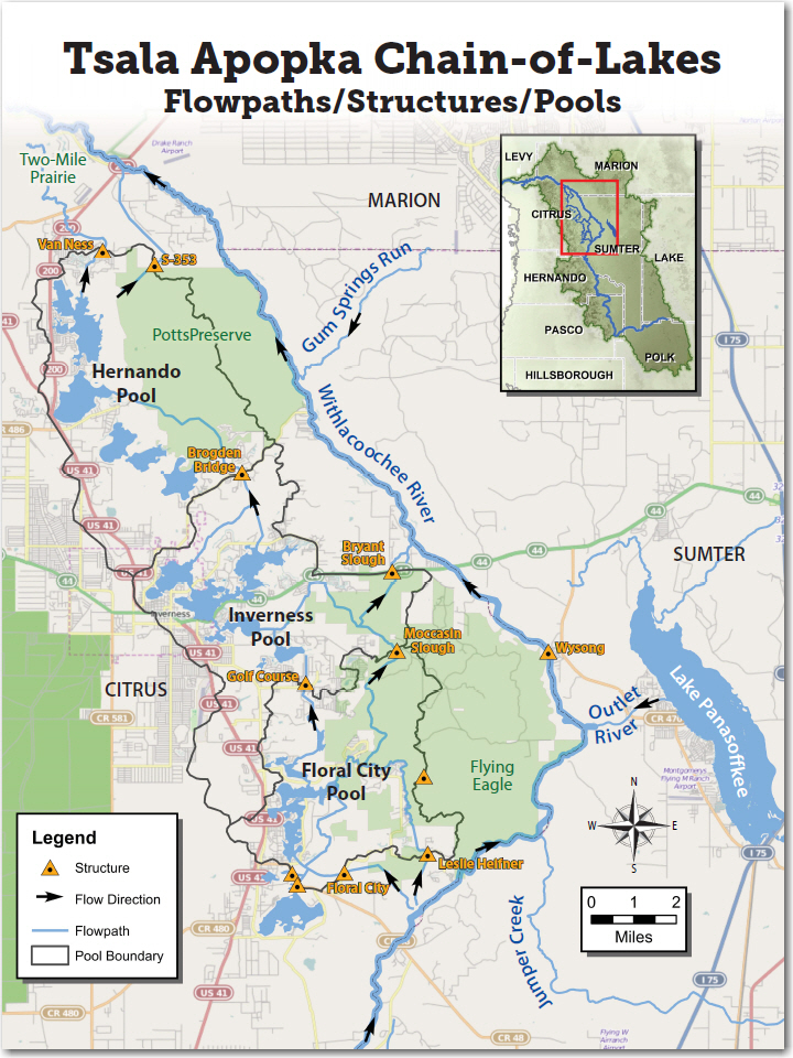
- Over the weekend, we’ve switched from filling the lakes to creating additional storage for the impending storm.
- The Leslie Heifner and Floral City Structures, which were bringing river water into the lakes, were closed on Sunday night.
- All structures that release water from the lakes are currently open, including S-353 which discharges water back to the Withlacoochee River.
- Water levels in all three pools are now dropping.
- The lakes are currently 5-6 inches below their respective high levels.
Lake Panasoffkee and Wysong Structure (Sumter County):
- Lake Panasoffkee is about 6 inches lower than its peak in mid-September.
- Inflows to the lake and outflow from the lake remain high from summer rains.
- The Wysong Structure on the Withlacoochee River is fully lowered, although the boat barriers (buoys) remain in place for now.
- River levels at Wysong are slightly below normal but are expected to rise following Hurricane Milton.
Stay safe!
-Mark


Mark Fulkerson, Ph.D., P.E.
Chief Professional Engineer
Southwest Florida Water Management District
(352) 269-6073 (office)
(352) 279-4493 (cell)

