|
Welcome to the Florida Geological Survey’s (FGS) News and
Research 2016 Summer Edition. Our GEOFACT for this issue explains the El
Niño/Southern Oscillation (ENSO) phenomenon, which can cause cyclic patterns
that have a dramatic impact on Florida's weather. Also in this issue, the FGS
is pleased to announce the expansion of its geologic sample repository;
the re-scanning of FGS publications into a higher-quality format than ever
before; Senate Bill 404 which enacted in 2015 a
“Geologist-in-Training" certification, allowing graduating geology
students to become certified Professional Geologists at a more accelerated
pace.
The Florida Geological Survey unveiled a new GIS-based website
when it hosted the 20th annual Digital Mapping Techniques Workshop in May
2016. The website showcases the STATEMAP Program’s
accomplishments over the last 22 years and allows the public to view and
download the most recent geologic maps covering approximately 45 percent of the
state.
Best regards,
Jonathan D. Arthur, Ph.D., P.G.
Director and State Geologist
Florida Geological Survey
Florida Department of Environmental Protection


Changes in Florida's hydrological cycle have a significant
impact on groundwater levels and spring flow. Short- and long-term changes in
weather significantly affect parts of this cycle. To fully understand Florida's
hydrology, it is important to not only understand seasonal changes in weather,
but also how weather is affected by climate.
El Niño/Southern Oscillation (ENSO) refers to a cyclical pattern
that develops in the equatorial Pacific Ocean and in the atmosphere above the
area. El Niño events occur when sea-surface temperatures off the Peruvian coast
become warmer than average. These events were originally recognized by
fishermen and usually coincided with Christmas, which is why the event is known
as El Niño ("the boy" in Spanish). The opposite effect, known as La
Niña ("the girl"), often follows El Niño and results in cooler than
average sea-surface temperatures in the region. Sometimes there is a period of
time between these two events where sea-surface temperatures are neutral.
The Southern Oscillation portion of this phenomenon describes
how sea-surface temperatures influence atmospheric pressure and easterly trade
winds. Low-level winds move toward areas of warmer sea water in tropical
latitudes. As these trade winds move across the ocean surface, warm water can
be pushed into the Western Pacific causing La Niña conditions (cooler than
average sea-surface temperatures) to prevail across the equatorial region of
the Eastern and Central Pacific. Conversely, when easterly trade winds become
interrupted and less persistent, sea-surface temperatures in the area can warm,
causing El Niño conditions. These oscillating patterns can have a dramatic
impact on weather in Florida.
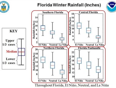
During El Niño events, Florida typically experiences cooler,
wetter winters. During La Niña, the opposite is true and Florida experiences
drier, warmer winters. Additionally, the ENSO patterns affect the frequency of
tropical storm formation. During strong El Niño events, there is a decline in
tropical storm activity, which affects annual rainfall totals. All in all,
Florida receives less annual rainfall during La Niña and receives above-average
rainfall during El Niño.
|
Graph showing rainfall in various
parts of Florida during El Niño, La Niña and neutral conditions (courtesy of
NOAA and the National Weather Service).
|
|
 |
 According to the National Oceanic and Atmospheric
Administration’s (NOAA) Climate Prediction Center, the federal agency that
provides ENSO information and predictions, the strong El Niño pattern that has
been active in 2015 and early 2016 is weakening. NOAA predicts that there is a
75 percent chance that La Niña conditions will develop during the fall and
winter of 2016-17. If this prediction is correct, Floridians can expect a warm,
dry winter.
Contact: Harley Means, P.G. Administrator
References
http://iri.columbia.edu/our-expertise/climate/enso/enso-essentials/
http://nws.weather.gov/blog/nwsjacksonville/2015/10/15/el-nino-and-its-effect-on-florida/
http://www.cpc.ncep.noaa.gov/products/analysis_monitoring/lanina/enso_evolution-status-fcsts-web.pdf
Back to top
Imagine having to take a final comprehensive
exam five years after you took the courses to prepare for it. That’s what it
has been like for geologists seeking a professional license in Florida, but not
anymore! Geologists can now take the fundamentals of geology portion of the
two-part exam while still enrolled in classes. Moreover, successful completion
of an application and the exam allows the up-and-coming geologist to display a
certificate that demonstrates they are serious about their chosen career – it
speaks “I am a Geologist-in-Training!”
In 1987, the Florida Legislature passed a bill requiring the
licensing of professional geologists (P.G.) in recognition that the work of
geologists can affect human health, safety and welfare. This bill required a
geologist who is performing geological services involving consultation,
investigation, evaluation, planning or geological mapping to pass an exam
administered by the Florida Department of Business and Professional
Regulation. While the law provides for exemptions (492.116 F.S.), all
final geological documents prepared for delivery to any person for Florida
public record requires the signature and seal of the professional geologist(s)
who prepared or approved them.
Over the years, refinements in the enabling statute, Chapter 492 F.S. and its associated rule, Chapter 61G-16 (1-9) F.A.C., have been made.
In brief, applicants must meet certain educational and work experience
requirements. The State of Florida’s Board of Professional Geologists (BOPG)
stringently examines applications for licensure. Once the statutorily defined
standards are met, the qualified applicant may take a two-part (fundamentals
and practical) examination developed by the National Association of State Boards of Geology.
The applicant must pass both exams to become licensed by the state of Florida
as a P.G. Until last year, the exam could not be taken until the applicant
demonstrated he/she held the educational requirements and five years of
appropriate work experience, all of which require approval by the BOPG.
With last year’s adoption of Senate Bill 404, the “Geologist-in-Training”
(GIT) registration option was enacted. This allows the prospective P.G.s to
take the fundamentals exam right after completing their college coursework or
in their last year of studies, by applying as a “Geologist-in-Training.” Once
the applicant has been approved to take, and has passed the fundamentals of
geology portion of the exam, he/she is registered as a GIT in the State of
Florida. The candidate may then complete the practical application exam at a
later date after demonstrating five years of work experience.
Learn more about the licensing of professional
geologists in Florida.
Contact: Clint Kromhout, P.G.
Administrator
Jonathan
Arthur, FGS Director and State Geologist
Back to top
|
The FGS, working in cooperation with the FSU
Geological Society, recently hosted the 20th annual Digital
Mapping Techniques (DMT) Workshop. Since its inception in 1997, the
DMT series has brought together scientists, cartographers and geographic
information systems (GIS) specialists from state and federal agencies along
with university professors, geologists and GIS specialists in the private
sector, and various international agencies to discuss new technologies,
strategies and techniques for collecting, maintaining and providing public
access to environmental and geological data. Techniques and strategies for data
stewardship and data preservation are a prominent theme among the many
presentations, discussion sessions and posters presented each year at the
workshop.
DEP and FGS staff contributed four presentations and three
posters to this year’s workshop. Dr. Jonathan Arthur, FGS director and state
geologist, and Kimberly Jackson, DEP GIS data processing manager, presented the
opening remarks and framed the importance of acquiring, archiving and distributing
environmental and geological data to the public. Katherine White, Levi Hannon
and Rick Green presented the STATEMAP story map, which compiles information
about the Florida STATEMAP program and provides public access to geological
maps in a user-friendly, interactive form. Jim Cichon presented the FGS interactive web map application for
viewing the FGS’ statewide potentiometric surfaces and historic water data for
the Upper Floridan Aquifer. Dr. Christopher Williams and Michelle Ladle
presented the FGS data management plans and strategies for archiving and
distributing more than 100 years of geological descriptions to the public. Seth
Bassett and Scott Barrett Dyer presented their work archiving and analyzing
springs data in the Woodville Karst Plain and Wakulla Spring.
FGS staff also presented three posters to the workshop
attendees: Casey Albritton, Seth Bassett and Scott Miller shared how to build
interactive 3D web applications in QGIS for viewing geologic data; Scott
Miller, Carroll Hageseth, Amanda Kubes and Sara Smith described sinkhole
assessment and mapping using LIDAR imagery and field verification; and Seth
Bassett, Katherine White, Tom Greenhalgh, Scott Barrett Dyer and Frank Rupert
provided a summary of karst hydrology research techniques pioneered by the FGS.
This year’s workshop hosted 65 attendees, including
representatives from the U.S. Geological Survey, the Canadian Geological
Survey, and representatives from 20 state agencies responsible for geological
and resources mapping in their respective states.
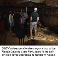
FGS staff, in cooperation with Florida State Parks, Jackson
County and DEP, also provided attendees guided tours of various locations
around North Florida including Florida Caverns State Park, the Jackson Blue
Springs Recreational Area, Madison Blue Springs, Suwannee River State Park and
various other locations of interest. Workshop attendees were also provided with
a tour of the new FGS facility at 3000 Commonwealth Blvd. and of the FGS core
and cuttings repository.
Contact: Seth Bassett, Environmental Specialist III
Back to top
|
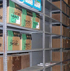 Nearly 8,000 square feet of storage improvements
were completed in May at the FGS sample repository located at 3915 Commonwealth
Blvd. in Tallahassee. This will provide for an estimated 16-20 years of
collections growth.
The Spring 2015 Edition of FGS News and Research
included a discussion of FGS’ statewide collection of subsurface well cuttings
and core samples. With more than 19,500 sets of well samples, this
collection is large and ever-growing, and care must be taken to plan for future
sample acquisitions and storage.
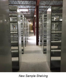
The sample repository facility occupies 12,090 square feet, with
nearly 35,000 cubic feet of shelf space. The heart and original portion of the
repository is a three-story steel shelving system.
There have been three expansions since the three-story system
was built; however, as of 2014, the shelves were projected to be full within a
few years, and FGS began working to secure more space for repository
growth.
In 2015, a plan was formed to convert the second floor of a DEP
warehouse to sample storage. Following an engineering analysis to ensure the
safety of building occupants and the collection, new shelving was ordered and
installed. The expansion was completed in May 2016, providing an additional
7,944 square feet of storage for an estimated 16-20 years of collections
growth. The new shelving arrived just in time, as the last rolling shelf unit
downstairs is approximately 75 percent full.
|
 |
|
The FGS extends its gratitude to DEP program
areas that provided assistance, including DEP Executive Leadership, the Bureau
of Design and Construction, Administrative Services, the Division of
Environmental Assessment and Restoration (DEAR), water management districts for
fiscal support, and all other program areas that helped provide the space
needed.
Contact: David Paul, P.G. Administrator
Back to top
|
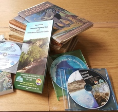
Publications by FGS are now available in a higher-quality format
than ever before. Not only can the publications be downloaded as PDF files, but
the documents are also searchable. This is expected to vastly increase the
usability of FGS archived scientific reports.
Early in 2015, FGS contracted with PRIDE Digital Services to
rescan its major publication series into high-quality PDF format. The project
was necessary because many of the FGS documents hosted by the University of
Florida Libraries were only available in an HTML file format; therefore, the
documents were not easily downloadable and of inferior quality.
FGS Librarian Specialist Doug Calman worked closely with PRIDE
to ensure that the final product was high quality, including making sure that
photographs were high quality, and there were no washed-out tables, charts or
graphs.
Documents now available to the public include: the bulletin
series, which are comprehensive reports on geology or related studies that
cover a broad area; selected Reports of Investigation, which are comprehensive
reports on geology or related studies; Information Circulars, reports of a
preliminary or interim nature or updated reports on continuing investigations;
and Map Series.
The resultant set of DVDs and PDF
files were placed where they could be accessed by the public via the FGS Web Catalog or the FGS List of Publications.
The FGS plans to continue scanning documents to provide even
more to the public in an easily accessible and searchable format.
The Florida Geological Survey is pleased to make these improvements for
its customers as a result of this successful partnership with PRIDE Digital
Services.
Contact: Alan Baker, P.G. Administrator
Back to top
|
|