|
Welcome to the Florida Geological Survey’s (FGS) News and Research Spring Edition. As Florida’s premier state government institution specializing in geoscience research and assessments, the FGS receives a multitude of questions about sinkholes and basic Florida geology. Less frequently, we are contacted by someone who has experienced mysterious booms or tremors. While earthquakes are extremely unlikely in Florida, it is possible for one to experience small tremors caused by other factors. This issue’s GEOFACT explores the possible causes of these experiences in Florida. Also in this issue, we discuss the transportable array, which measures variations in the Earth’s crust and provides insight into Florida’s geologic structures, as well as updates on our education and outreach efforts and successful internship program.
In March, P.G. Administrator Frank Rupert retired from the FGS after 30 years of dedicated service. Frank’s warm personality and vast scientific expertise will be sorely missed. However, his FGS family wishes him a wonderful retirement that is certainly deserved. In recognition of his outstanding career and geoscience contributions, Frank was presented with a Herman Gunter Lifetime Achievement Award.
In closing, please join me in congratulating Jim Cichon, Environmental Consultant, for being presented with a DEP STAR Award by DEP Secretary Jon Steverson. Jim is the lead on our statewide potentiometric mapping program. Read on to learn about other exceptional FGS employees who were honored for their “above and beyond” public service.
Jonathan D. Arthur, Ph.D., P.G.
Director and State Geologist
Florida Geological Survey
Florida Department of Environmental Protection
Note new address:
3000 Commonwealth Boulevard, Suite 1
Tallahassee, Fl 32303
Office: (850) 617-0320
Cell: (850) 591-5174


Every now and then, the Florida Geological Survey (FGS) is contacted by someone who has witnessed mysterious booms or tremors. The people who call are often concerned that they may be experiencing an earthquake or a sinkhole, or describe what they were hearing and feeling as very loud, abrupt and nearly rhythmic booms. There are explanations for the booms and tremors experienced in Florida, which include lightning, sonic booms, blasting and ordinance testing.
|
This photo shows the result of one of
the explosions that occurred as part of the study in Germany (central ring just south of Berlin). The cross-hatched regions indicate areas where the explosion was heard. The ring-like structures show that zones of audibility alternated with zones of silence, indicating that sound refraction was taking place in the stratosphere.
(Fig. 10, Gabrielson, 2006).
|
|
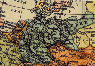 |

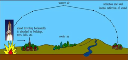
Sound, pressure and shock waves can travel for long distances, and can even be focused over those long distances into small areas. For example, a study from Germany after World War I involved setting off a large explosive device just south of Berlin to see where it was reported to be heard in the surrounding countryside. The experiment proved that sound not only propagated out from the center of the explosion, but upward as well. When the sound waves entered the stratosphere, they were subsequently refracted back towards Earth, allowing the explosion to be heard much farther away than previously thought possible. This phenomenon is known as atmospheric refraction or ducting, which describes the process by which sound travels faster in warm air (such as between clouds) versus cooler air (near to land surface). The sound can be focused back down to the ground where breaks in the clouds exist. Similarly, we observe this same phenomenon in Florida, which is pictured above.
|
Here are some of the common sources of booms and tremors in Florida:
- Lightning and Thunder – Florida is the lightning capital of the United States, and where there is lightning, there is thunder. Thunder is a loud, explosive, resounding noise produced by the expansion of air heated by a lightning discharge. Florida’s position between the Gulf of Mexico and the Atlantic Ocean makes it prime location for the formation of thunderstorms. Thunder can be heard large distances away from the lightning strikes occur. Florida averages 1.45 million lightning strikes each year.
- Sonic Booms – The vast majority of mysterious booms and tremor-like experiences in Florida are the result of supersonic flight. Florida is home to multiple military air bases, fields and stations. Florida’s citizens routinely witness military aircraft performing training exercises and certain types of aircraft have the ability to fly supersonically. Since March of 1973, the Federal Aviation Administration has prohibited supersonic flight over land by civil aircraft. However, military aircraft, including NASA aircraft, do not fall under FAA regulations and can fly supersonic.
-
Commonly, supersonic military flight in Florida is offshore over the Atlantic Ocean and Gulf of Mexico. At times, the sound waves from the sonic booms associated with those flights are felt on the land. Citizens in the area where those sound waves propagate can experience focused loud booming noises and shaking.
- Blasting - Mining is a global industry and much of the targeted material is solid rock buried deep below the Earth’s surface. Often times, explosives are used to make these deposits accessible. When blasting takes place at a mine, charges are usually set off as a single blast or in a series to reduce the intensity. Blasting may produce audible booms (sound waves) or inaudible/concussion (pressure waves). Blasting information and complaints in Florida are handled by the Florida Department of Financial Services, Division of State Fire Marshal.
Less common, but still possible, sources of booms in Florida include:
- Distant Earthquakes – Florida is located on a passive continental margin, which means that there are no tectonic plate boundaries nearby that can cause earthquakes, however, earthquakes sometimes occur in areas close enough to be felt. For example, the catastrophic 2010 earthquake that ravaged Haiti was also felt in Florida, and the 2006 Gulf of Mexico platform quake, an intraplate earthquake, was large enough to be felt in most gulf coast states and as far north as Atlanta, Georgia. Both of these earthquakes were significant enough to be recorded by water-monitoring wells in Florida.
- Volcanoes – Like earthquakes, volcanoes typically occur at plate boundaries, like the perimeter of the Pacific plate known as the “Ring of Fire.” The closest volcanoes to Florida are in the islands of the Caribbean Sea and pose little direct threat to Florida. The eruption of Krakatoa in 1883 was loud enough to be heard from over 2,000 miles away and is, to this date, the most distant sound that has ever been heard in recorded history.
-
Sand Dunes – It has been documented historically by scientists that sand dunes can produce a variety of noises under the right conditions. A study in 2006 by researchers from the California Institute of Technology in Pasadena have measured sounds waves made by shifting desert sand dunes in eastern California and Nevada and believe that friction between the sand grains creates sound that reverberates back and forth between dry sand at the surface and wet sand deeper within the dune (National Geographic News, Oct. 20, 2004). Florida’s active sand dunes are concentrated on formation of barrier islands. Many of these dunes have vegetation growing on them that would resist erosion and movement of large quantities of sand at one time. However, there are still areas where plentiful beach dunes could be large enough to produce some of the mysterious sounds associated with shifting sand bodies that are observed and documented elsewhere in the world.
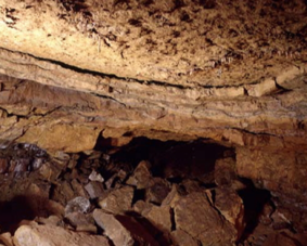
- Underground Rock Collapse – Underground rock collapses are common in certain areas where the underlying geology is conducive to such activity. In Florida, much of the state is underlain by cavernous limestones that have varying thicknesses of overlying strata above them. This is also one of the prime mechanisms for sinkhole formation in Florida. As the cavities in the limestone become larger, the limestone becomes less able to support the weight of the overlying sediments and/or rock. Once the strength of the limestone reaches a critical point, the rock collapses and the overlying material funnels into the void space below. While it is probable that a person could hear the collapse above ground if the rock and cavity were unsaturated, it is unlikely a sound would be audible in a saturated rock environment.
|
Sources of booms that are extremely rare anywhere include the following:
- Meteors – The Earth does experience its fair share of space debris colliding with the atmosphere. However, it is exceedingly rare for any of these meteors to maintain composure after traveling through the atmosphere. Occasionally, one of these bodies will be large enough to make it through the atmosphere without completely burning up and may even explode high in the atmosphere (as was the case in the Russian meteorite event in 2013) causing a loud boom and shockwave that can be heard and felt over a large area.
- Exploding Gas – Natural gas deposits are common in the subsurface of many areas around the state of Florida and extend offshore in many areas as well. However, these deposits are trapped in deeply buried rocks at depths greater than 10,000 feet below sea level. The release of these gases with enough force to produce an explosion with an audible boom would require them to be entrained in the subsurface under extremely intense pressure. Even if these conditions were met, it is extremely unlikely that it would result in an explosion because oxygen is needed as a catalyst for combustion. There are areas in the world where natural gas is continuously venting and is aflame, notably at Mount Chimaera in Turkey, but these are areas close to active tectonic margins (plate boundaries) and dramatically different than Florida’s geological setting.
Contact: Casey Albritton, Geologist
Clint Kromhout, P.G. Administrator
References
Gabrielson, T. B., 2006, Refraction of Sound in the Atmosphere: Acoustics Today, April 2006.
Lovgren, Stefan, 2004, National Geographic News: Why Sand Dunes Go Boom: http://news.nationalgeographic.com/news/2004/10/1020_041020_sand_dunes.html (accessed March, 2016).
Ray, Claiborne, 2003, The New York Times: Science: Q & A; Noise in Earthquakes: http://www.nytimes.com/2003/12/16/science/q-a-noise-in-earthquakes.html (accessed March, 2016).
Vergano, Dan, 2013, National Geographic News: Russian Meteor’s Air Blast was One for the Record Books: http://news.nationalgeographic.com/news/2013/11/131106-russian-meteor-chelyabinsk-airburst-500-kilotons/ (accessed March, 2016).
Back to top
The mission of the FGS is to collect, interpret and provide objective, quality information about Florida to its customers. One way FGS accomplishes its mission is through various education and outreach events. Since December, FGS staff have taken part in a variety of events around the state.
FGS staff geologists and interns regularly provide expertise at local school events, such as judging science fairs. During December 2015, Katie White volunteered as a judge at Swift Creek Middle School for its annual science fair, and Cindy Fischler, Sarah Lovins and Zachary Zarranz served as judges at the Deer Lake Middle School Science Fair. In addition, Brianne Apolinar and Kirstyn Cataldo volunteered to instruct the SciGirls Club at Raa Middle School on how to view rock and mineral samples under a microscope. The SciGirls also learned about earth-science careers and were provided with an overview of Florida geology, including a discussion of how sinkholes form.
In addition to science fairs and school events, FGS geologists are often asked to provide lectures to various civic and local interest groups on geoscience topics. During January and February, Harley Means provided lectures to the Ridge Audubon Society and to the South Florida Museum’s Think and Drink Science Lecture Series. Both lectures highlighted the link between geology and Florida’s outstanding water resources. Florida’s karst geology provides the geologic setting where more than 1,000 springs, 7,800 freshwater lakes, 1,700 rivers and streams, and the Floridan aquifer system exist.
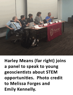
Helping young students learn about career opportunities in the geosciences is another way FGS staff provide outreach and education. On February 23, 2016, Harley Means sat on a panel of invited guests who work in the science, technology, engineering and mathematics (STEM) fields. The panel was put together and hosted by the Florida State University Career Center and was attended by more than 60 high school and first-year college students interested in pursuing careers in STEM fields. The attendees asked the panelists questions about how they began STEM careers, how to academically prepare for a career in a STEM field, and which STEM careers would be economically prudent to pursue.
February continued to provide more opportunities for FGS to reach out to Florida’s citizens. For example, Mary Beth Lupo had the opportunity to serve as a judge at the Capital Regional Science Fair at Florida State University. The FGS also welcomed visitors to the Walter Schmidt Museum of Florida Geology, which is open to the public.
During March, Harley Means provided a lecture on Florida’s springs at the Florida SpringsFest at Silver Springs State Park. He also met a University of Florida Paleontology class at Gulf Coast Aggregates and St. George Island to discuss geology and manned a booth at the FSU U.S. Government and Social Services Career Fair to discuss jobs in the geosciences with interested students. Director Jon Arthur finished up the month of March by serving as a guest speaker for an FSU Environmental Science Capstone course on March 30.
Contact: Harley Means, P.G.
Back to top
|
The Florida Geological Survey (FGS) has operated an internship program since 2013. To date, more than 40 students have contributed over 5,400 hours to the state, and for the current spring semester, FGS has eight part-time interns contributing approximately 80 hours per week. Through the internship, these future earth scientists get valuable work experience in a professional environment as well as opportunities to learn about Florida’s geology and environment.
Students participating in the internship program at the FGS work on a variety of tasks including data entry, sample management and processing, Geographic Information System (GIS), well verification and data accreditation, field work, scanning and preservation of paper media, and education events.
When a student begins in the FGS Internship Program, they are introduced to databases and data management strategies. This involves entering data from paper documents, which may consist of driller’s logs or notes, lithologic descriptions, and sample check-in sheets that record inventories held in the FGS repository. Once the intern has a good working knowledge of the data, the student begins working on GIS tasks after a quick tutorial. Upon completion, the intern can go on to perform many other jobs for various areas of the FGS. They are encouraged to attend staff meetings and presentations, and interact with other geoscientists in an effort to broaden their skills.
Upon graduation, entry-level OPS positions at the FGS are regularly filled by selecting outstanding interns from the program, and many of our interns are accepted at graduate schools across the country. Potential interns should have a declared major in one of the physical sciences or environmental science. Students are asked to contribute at least eight hours per week at the FGS. More information on the FGS Internship Program can be found here.
Contact: Alan Baker, P.G. Administrator
|
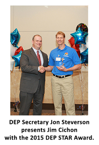
Jim Cichon, Florida Geological Survey (FGS) Environmental Consultant was among the DEP employees honored at the Fourth Annual DEP STARS Award Ceremony held in Tallahassee on April 5. The ceremony recognized top performers from 2015 who were selected from around the state by their peers and managers as our most stellar environmental stewards. For more information about Jim Cichon and the STAR Award Ceremony, click here.
Top performers of 2015 were also recognized at the recent FGS Awards Ceremony held at the Maclay Gardens Cottage on April 7.
Christopher Williams, Professional Geologist II, was honored as the Employee of the Year for 2015. Christopher’s invaluable contributions to multiple projects at FGS and dedication make him an invaluable asset to FGS. Because of Christopher’s diligence, FGS had a record-breaking turnout of over 250 visitors for our Earth Science Week Open House last year.
It was also announced that Frank Rupert, who recently retired from FGS, was being awarded with the Herman Gunter Lifetime Achievement Award. This special award recognizes outstanding and dedicated contributions to the goals and values of the FGS over the course of the recipient’s career. More information about Frank Rupert is available in this Spring issue of FGS News and Research.
Jesse Hurd, Laboratory Technician III, was honored with the Sustained Exemplary Performance Award for his work processing new samples and adding them to the FGS repository collection, and well as checkouts and deliveries. This work affects nearly every person at FGS because access to geologic samples is the foundation for geologic interpretation. Jesse’s strong work ethic and willingness to go above and beyond make him deserving of this recognition.
An Individual Extra Effort Award was presented to Kathryn Etheridge, Archivist II, for her diligent work with data organization, correction, and digitization related to FGS geologic collections. At the end of 2015, she provided insight for the newest National Geologic and Geophysical Data Preservation Program grant proposal and visited the Geological Survey of Alabama during the holidays to improve communications and share repository methods.
Doug Calman, Librarian Specialist, was also awarded an Individual Extra Effort Award for undertaking one of the largest aspects of the FGS relocation from the Herman Gunter Building to 3000 Commonwealth Boulevard during 2015. The task included planning and designing the new FGS library, ordering shelving and moving supplies, and coordinating the library move to make sure everything was planned and implemented on time.
|
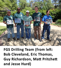
A Team Extra Effort Award was presented by 2015 FGS Awards Chairman Rick Green to the FGS Drilling Operations team, which consists of Bob Cleveland, Jesse Hurd, Matt Pritchett, Guy Richardson and Eric Thomas. The team works on multiple projects, spends back-to-back weeks often under difficult conditions, trains OPS staff and interns, and meets deadlines ahead of schedule.
The Sinkhole Vulnerability Team also received a Team Extra Effort Award for their work on a project funded by the Department of Emergency Management. They include Casey Albritton, Adam Aspinwall, Jim Cichon, Carroll Hageseth, Amanda Kubes, Scott Miller, Taylor Murray, Geoff Perkins, Sara Smith, Christopher Williams and Zachary Zarranz. Under the supervision of P.G. Administrators Clint Kromhout and Alan Baker, the team spent more than 21,000 hours working toward mapping the state’s vulnerability to sinkhole formation.
Finally, the FGS Interns that put in many hours during 2015 were recognized. They include Charles Boyd, Christopher Crevello, Hilary Davis, Nicholas Houston, Shelby Jablon, Luke Millan, Lena Mollica, Joseph Ottolino and Robert Speirs.
Contact: Mary Esposito
|
On March 11, the Florida Geological Survey (FGS) bid a fond farewell to a beloved coworker, Frank Rupert. While Frank had an impressive career, his kind and refreshing personality will be missed most as he embarks on retirement.
Frank was hired in 1986 to use his geological, hydrogeological and paleontological expertise to write and publish reports, as well as collect, analyze and interpret geological data. He received his Professional Geologist (PG) license in 1990 and he was ultimately promoted to a PG Administrator, heading up the FGS’ Applied Geoscience Services Section.
In 30 years of dedicated service, Frank has produced 60 publications. Frank’s excellent work has been recognized by staff over the years, including two Employee of the Year Awards (1988 and 2009) and multiple Extra Effort Awards. Calling Frank a team player would be an understatement, as he constantly took on additional work to meet the needs of the FGS. Examples include design work, mastery of publication software, education and outreach poster design and development, GIS work, and serving as the FGS webmaster. He was also responsible for special publications such as one celebrating the FGS Centennial, various Biennial Reports and assembling the FGS News and Research Newsletter. Frank provided guidance and support for numerous FGS projects by editing documents and reviewing deliverables with superb attention to detail. Frank showed a keen ability to promptly recognize needs and assist people in various ways, whether it was fossil recognition, sinkhole inspection or even photography.
Frank’s friendliness, kindness and honesty make him an approachable and extremely likable person. He is a wonderful friend and mentor because he treats everyone with respect and concern. He has shown a commitment to excellence and to the FGS values, and is respected by all of his colleagues. In April, Frank was honored with the Herman Gunter Lifetime Achievement Award, the most prestigious FGS award given to those who have provided high-quality service to the FGS over many years.
Frank was a tremendous asset to the FGS, and he will be missed. He led an admirable and productive career and the FGS wishes him luck as he begins his retirement.
Contact: Sarah Erb
|
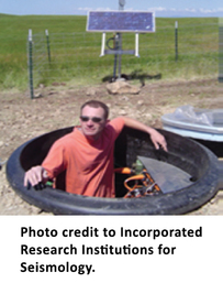
A seismograph is an instrument that measures and records details of earthquakes, such as force and duration, and also helps to map variations in the earth’s crust. As part of an ongoing project sponsored by the National Science Foundation (NSF), the U.S. Geological Survey (USGS), the U.S. Department of Energy (DOE) and the U.S. Nuclear Regulatory Commission (NRC), a group of seismographs has been installed in bands across the United States since 2007 and reached the East Coast in 2013. This group is known as “The Transportable Array” (TA). The TA consists of a network of 400 broadband seismograph and atmospheric sensor stations, which were installed in north to south trending bands in a regular grid pattern at temporary sites across the lower portion of the United States (Earthscope 2016). The stations collected seismic data from earthquakes that occurred around the globe and the data was used to detect small-magnitude earthquakes and map the structure of the Earth’s interior.
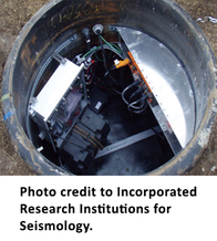
In Florida, 27 TA stations were installed in intervals of about 43.5 miles (Earthscope 2016). Additionally, eight stations were located in southern Alabama and Georgia in close proximity to the Florida state line. After two years, most of the instruments in Florida were moved elsewhere in the United States. Currently, five TA stations remain operational in Florida, and are maintained as part of the Central and Eastern United States Network (CEUSN) Project. The CEUSN Project is jointly sponsored by the NSF, the USGS, DOE and the NRC. These stations are currently funded through 2017 and the USGS is working to procure funding for longer operation.
|
In the United States, the TA has provided insight into variations in the thickness of the Earth’s crust and the movement of the Earth’s tectonic plates. High-resolution three dimensional images and seismic velocity maps extending miles deep into the mantle have been prepared using the data. Additionally, the data has been used to gain a clearer understanding of variations in the temperature and strength of the Earth’s mantle. Analysis of the data from the TA stations located in Florida, southern Alabama and Georgia will provide insight into deep geologic structural features underlying Florida.
|
Contact: Dan Phelps, P.G.
References:
EarthScope. "Transportable Array." USArray -. Incorporated Research Institutions for Seismology, n.d. Web. 29 Mar. 2016.
|