|
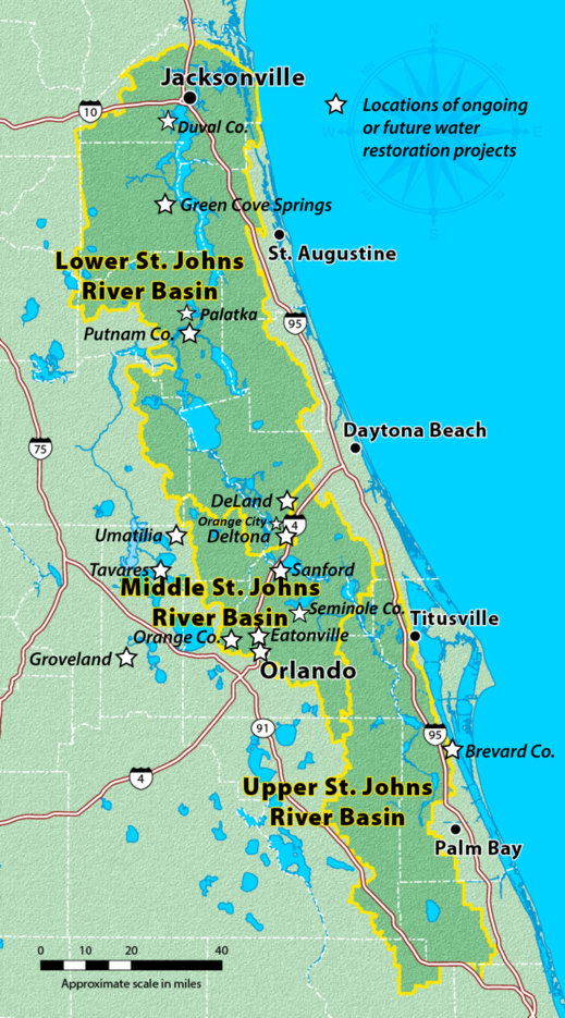
Locations of Ongoing or Future Water Restoration Projects
~ 18 Ongoing/Future Projects and 22 Completed Projects to Benefit the St. Johns River ~
Decades
of human activities have affected water quality in portions of the river. DEP and stakeholders address these impacts by implementing projects that reduce or
eliminate stormwater runoff from urban areas, treat domestic and industrial
wastewater, and require best management practices that conserve water,
reduce fertilizer usage and decrease runoff from farming areas. This
map reflects ongoing and future projects.
Stretching 310 miles from marshy headwaters
in Indian River County to the Atlantic Ocean in Duval County, the St. Johns
River is one of the few rivers in the United States and the
world that flows south to north. The
river boasts rich history and culture, plays an
important economic role for surrounding communities and
serves as home for people and wildlife alike.
To benefit and protect St. Johns River, the Florida Department of Environmental Protection, the St. Johns River Water Management District and local governments have invested nearly $265 million and implemented 40 projects to help improve water quality in the past five years.
Additionally, DEP has adopted restoration plans, or Basin Management Action Plans (BMAPs), for the Lower St. Johns River Main Stem, Lower St. Johns River Tributaries I and II, and Lakes Harney and Monroe and the Middle St. Johns River.
DEP, in partnership with St. Johns
River Water Management District and local stakeholders, is committed to
continuing efforts to improve water quality and quantity of the St.
Johns River for current and future generations.
Learn more quick facts about the St. Johns River.
Restoration of the St. Johns River and Tributaries
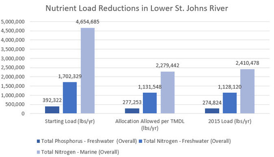
Lower St. Johns River Main Stem
Since
the restoration plan, or Basin Management Action Plan, was adopted in 2008
for the Lower St.
Johns River Main Stem, water quality continues to improve.
Significant strides have been made to upgrade wastewater facilities,
reduce agricultural runoff and increase urban stormwater treatment. To date,
projects and activities undertaken by local governments and others have reduced
90 percent of the total phosphorous loadings and
reduced 84 percent of the total nitrogen loadings in the river’s freshwater section to achieve healthy
chlorophyll-a levels. Also, a reduction of 94 percent of the total
nitrogen loadings in the marine section have helped
restore dissolved oxygen levels, which benefit
aquatic life.
Local projects are projected to meet, or even exceed, targets to reduce pollution for both nitrogen and phosphorous sections of the
St. Johns River.
Lower St. Johns River Tributaries I and II
Additionally, BMAPs were adopted in 2009 and 2010 to address bacteria impairments in 25 Lower St. Johns River tributaries. These BMAPs address excess concentrations of bacteria in tributaries that receive stormwater runoff from highly urbanized areas. Trout River (Middle Reach), Newcastle Creek, Deep Bottom Creek and Moncrief Creek are all showing water-quality improvements, with most recent monitoring results demonstrating less frequent fecal coliform criteria exceedances.
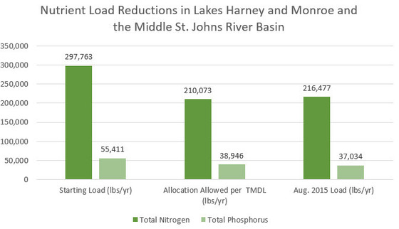
Lakes Harney and Monroe and the Middle St. Johns River (MSJR) Basin
An
additional restoration plan was adopted in 2012 for Lakes Harney and
Monroe and the Middle St.
Johns River (MSJR) Basin, which includes the main stem segments located between
the inlet of Lake Harney and the confluence of the St. Johns River with the
Wekiva River. DEP identified these waterbodies as impaired by nutrients and low-dissolved oxygen, and in December 2009 adopted
TMDLs to reduce phosphorus and nitrogen for
the lakes and river segments.
As of August 2015, more than 81,000 pounds per
year of total nitrogen and more than 18,000 pounds per year of total
phosphorous have been eliminated from entering these water bodies. Total
nitrogen has been reduced by 93 percent and total phosphorous has been
reduced by 112 percent, exceeding the nutrient reduction target.
Click here to read more.
 In addition, the restoration plans for the river
and tributaries, the department has also adopted restoration plans
for the Wekiva River, Silver Springs, Lake Jesup, Orange Creek and the
Upper Ocklawaha River Basin, which will also provide ancillary benefits to the
river by improving water quality basin-wide.
|