5 Day Statewide Weather Outlook for Fri 4/11 to Tue 4/15
Florida Division of Emergency Management sent this bulletin at 04/11/2025 03:06 PM EDT
This update is intended for government and emergency response officials, and is provided for informational and situational awareness purposes only. Forecast conditions are subject to change based on a variety of environmental factors. For additional information, or for any life safety concerns with an active weather event please contact your County Emergency Management or Public Safety Office or local National Weather Service forecast office.
You are subscribed to 5 Day Weather Outlook for Florida Division of Emergency Management. This information has recently been updated, and is now available.
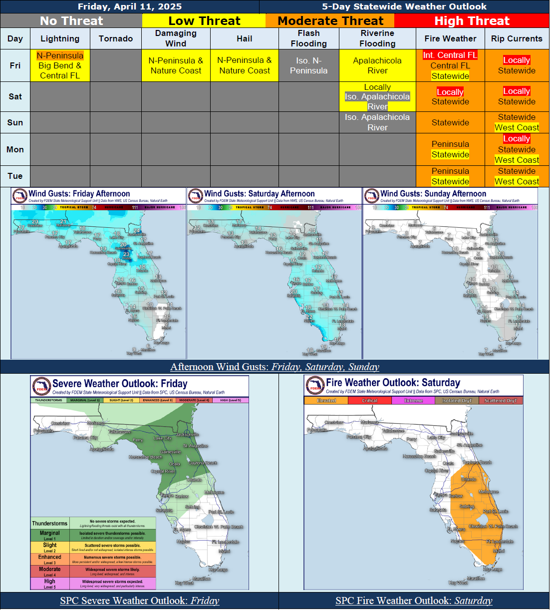
...Showers With Embedded Thunderstorms Expected to Develop Across the Big Bend and Northern Peninsula This Afternoon and Evening, Spreading Southward Towards the I-4 Corridor Into the Overnight Hours Ahead of A Cold Front Moving Southeastward Through the State…The Storm Prediction Center (SPC) is Outlooking a Marginal Risk (Level 1 of 5) for Severe Weather Across the Northern Peninsula and Nature Coast; Strong to Severe Thunderstorms Producing Frequent Lightning, Damaging Wind Gusts, Hail, and Locally Heavy Downpours Possible…Mostly Dry Conditions Return Statewide This Weekend and Persist Into Early Next Week Under High Pressure…Slightly Cooler Temperatures Briefly Return In the Wake of the Cold Front…Breezy Winds Near 10-15 MPH With Gusts Near 15-25 MPH Expected Statewide Today and Saturday…Sensitive to Elevated Wildfire Conditions Expected In the Afternoons and Evenings As Dry Air Filters In Behind the Cold Front…SPC Is Outlooking An Elevated Risk (Level 1 of 3) for Fire Weather Along Portions of the Peninsula Today and Saturday…Red Flag Warnings Issued For Portions of Interior and East-Central Florida This Afternoon and Evening; Additional Red Flag Warnings Possible This Weekend…Weaker Winds to Help Reduce Overall Wildfire Threat Late This Weekend Into Early Next Week…Minor Riverine Flooding Persists Along the Apalachicola River As Water Levels Gradually Fall…A Low to Moderate Risk for Rip Currents Can Be Expected Nearly Statewide With Locally High Risk Possible At Times…
…Have A Wonderful Weekend!...