5 Day Statewide Weather Outlook for Fri 4/4 to Tue 4/8
Florida Division of Emergency Management sent this bulletin at 04/04/2025 03:10 PM EDT
This update is intended for government and emergency response officials, and is provided for informational and situational awareness purposes only. Forecast conditions are subject to change based on a variety of environmental factors. For additional information, or for any life safety concerns with an active weather event please contact your County Emergency Management or Public Safety Office or local National Weather Service forecast office.
You are subscribed to 5 Day Weather Outlook for Florida Division of Emergency Management. This information has recently been updated, and is now available.
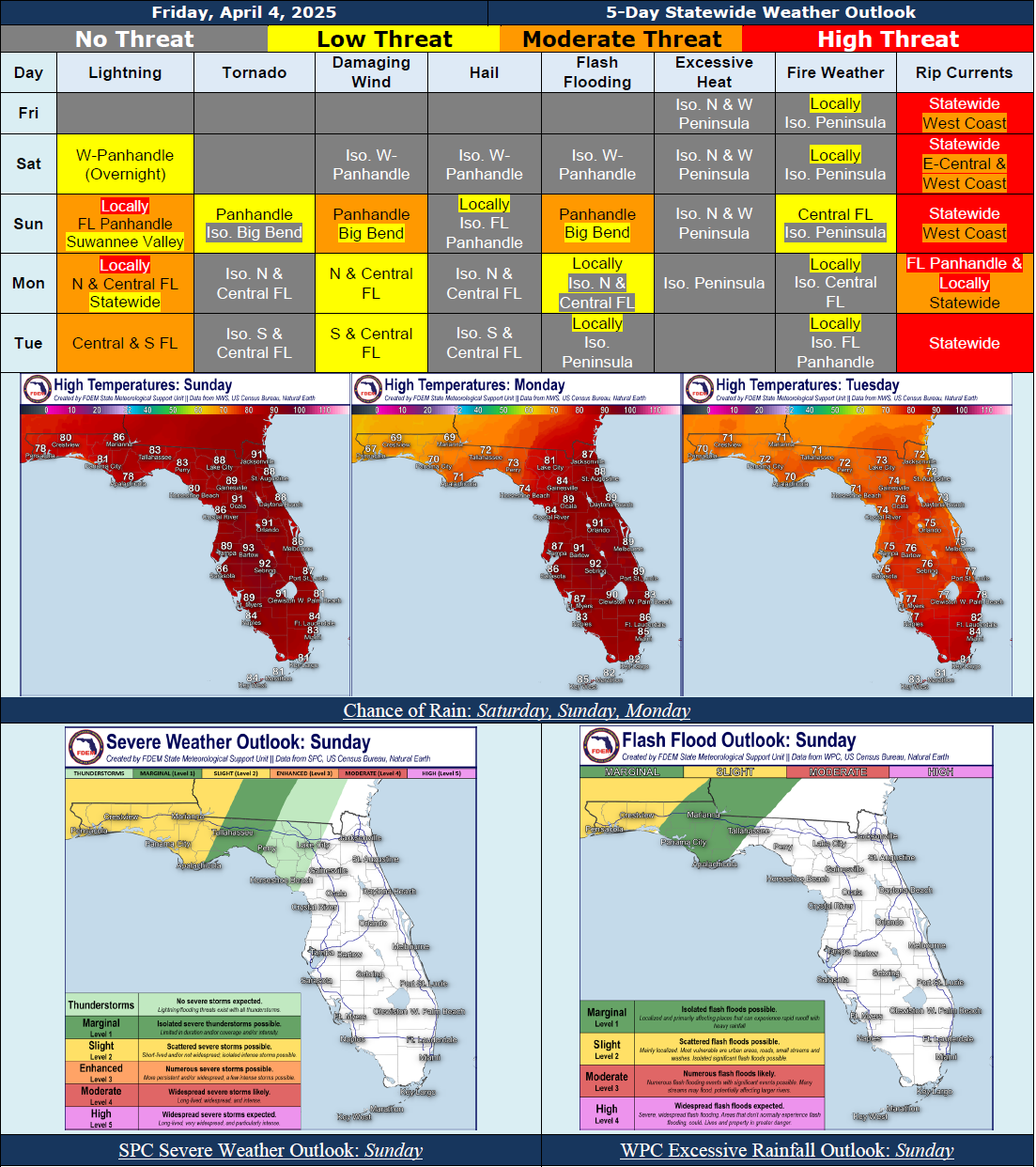
...Warm and Dry Conditions Persist Statewide Through Saturday and Along the Peninsula Sunday Under High Pressure Influences…Active Weather Pattern To Develop Along the Florida Panhandle Sunday, Spreading Eastward Into the Big Bend and Northern Peninsula Then Southward Through the Peninsula Early Next Week As a Cold Front Moves Through the State…Slight Risk (Level 2 of 5) for Severe Weather Along the Panhandle Sunday; Marginal Risk (Level 1 of 5) Extending Into the Big Bend; Damaging Wind Gusts and Isolated Tornadoes Possible…Slight Risk (Level 2 of 4) for Flash Flooding Along the Western Panhandle Sunday; Marginal Risk (Level 1 of 4) Extending Into the Big Bend Sunday; Marginal Risk Across the Northern Peninsula Monday; Instances of Flooding and Ponding of Water Possible…Potential for Locally Strong to Severe Thunderstorms and Localized Instances of Flooding May Continue Into Early Next Week…Cooler and Drier Conditions Expected Behind the Cold Front As High Pressure Shifts Eastward Over the Eastern U.S…Breezy Winds Near 5-15 MPH With Gusts Near 15-30 MPH Expected Outside of Thunderstorms Throughout Much of the Forecast Period…Elevated Water Levels and Localized Instances of Minor Coastal Flooding Expected At Times of High Tide Along the Florida Panhandle and West Coast Through the Weekend, At Least…Moderate to High Risk for Rip Currents Nearly Statewide Throughout the Forecast Period…
…Have A Wonderful Weekend!...