5 Day Statewide Weather Outlook for Fri 3/28 to Tue 4/1
Florida Division of Emergency Management sent this bulletin at 03/28/2025 04:33 PM EDT
This update is intended for government and emergency response officials, and is provided for informational and situational awareness purposes only. Forecast conditions are subject to change based on a variety of environmental factors. For additional information, or for any life safety concerns with an active weather event please contact your County Emergency Management or Public Safety Office or local National Weather Service forecast office.
You are subscribed to 5 Day Weather Outlook for Florida Division of Emergency Management. This information has recently been updated, and is now available.
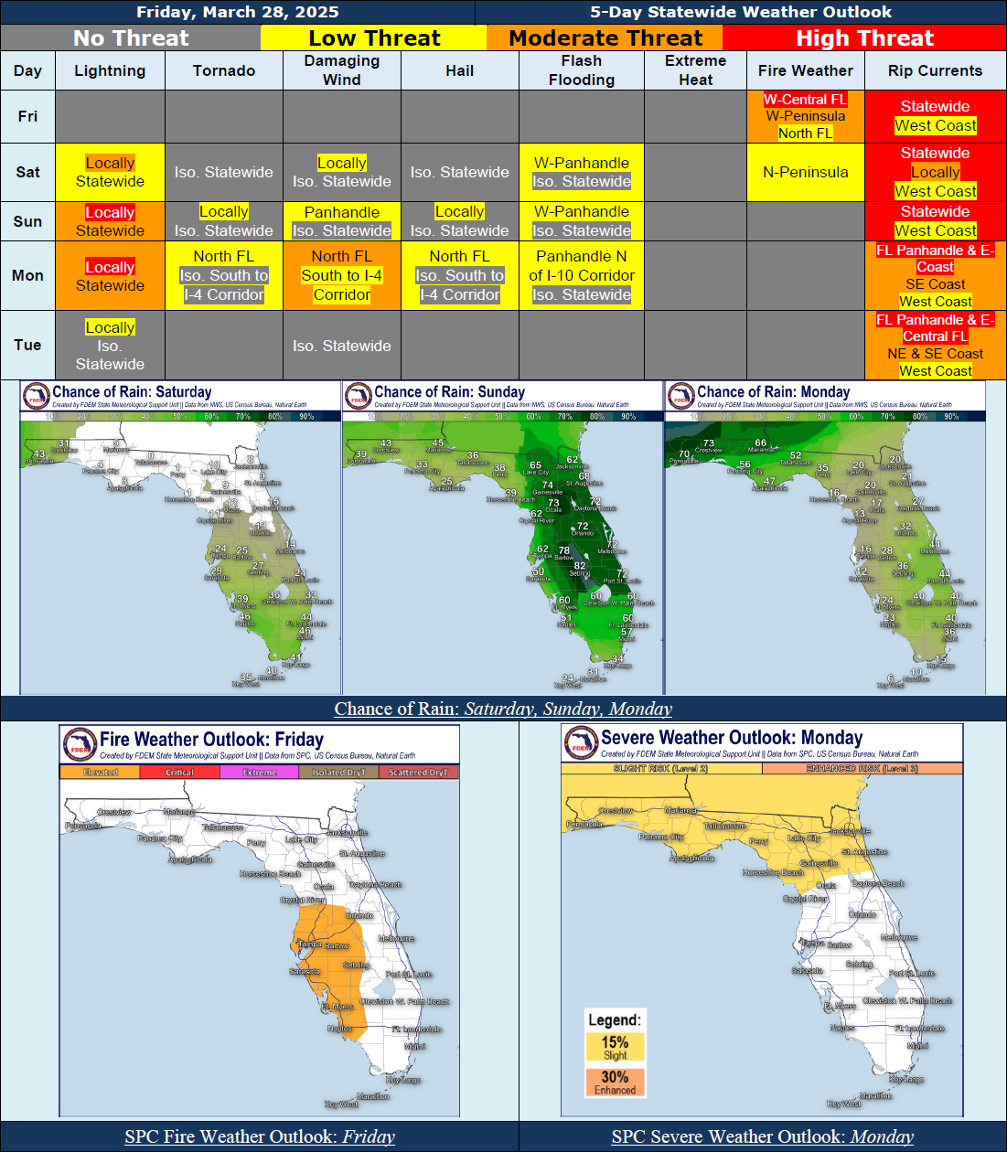
...Mostly Dry Conditions Today…Unsettled Weather Pattern Returns This Weekend, Continuing Into Early Next Week...Marginal Risk For Severe Weather Along the Panhandle Sunday With Activity Ahead of the Next Cold Front…15% Probability (Equivalent to A Slight Risk For Severe Weather) Across North Florida Monday As the Next Cold Front Moves Into the State; High There Is High Uncertainty IN the Forecast For This Activity and Updates Can Be Expected In the Coming Days...Localized Instances of Flooding and Ponding of Water May Be Possible At Times This Weekend and Early Next Week (Marginal Risk for Flash Flooding)…Above Normal Temperatures and 90-Degree Heat Indices Expected Despite Incoming Cold Front…Breezy Winds With Gusts Near 15-30 MPH to Persist Through the Weekend and Into Early Next Week…Sensitive to Elevated Wildfire Conditions Persist Today and Saturday; The Storm Prediction Center is Outlooking an Elevated Fire Weather Risk Across West-Central Florida Today; Red Flag Warnings In Effect Across West-Central Florida Through This Evening…Hazardous Beach and Boating Conditions Expected Through the Weekend, At Least Due to Breezy Winds and Ocean Swells…High Risk for Rip Currents Along the Florida Panhandle; Moderate to High Risk Along the East Coast…
…Have A Wonderful Weekend!...