5 Day Statewide Weather Outlook for Fri 3/21 to Tue 3/25
Florida Division of Emergency Management sent this bulletin at 03/21/2025 02:28 PM EDT
This update is intended for government and emergency response officials, and is provided for informational and situational awareness purposes only. Forecast conditions are subject to change based on a variety of environmental factors. For additional information, or for any life safety concerns with an active weather event please contact your County Emergency Management or Public Safety Office or local National Weather Service forecast office.
You are subscribed to 5 Day Weather Outlook for Florida Division of Emergency Management. This information has recently been updated, and is now available.
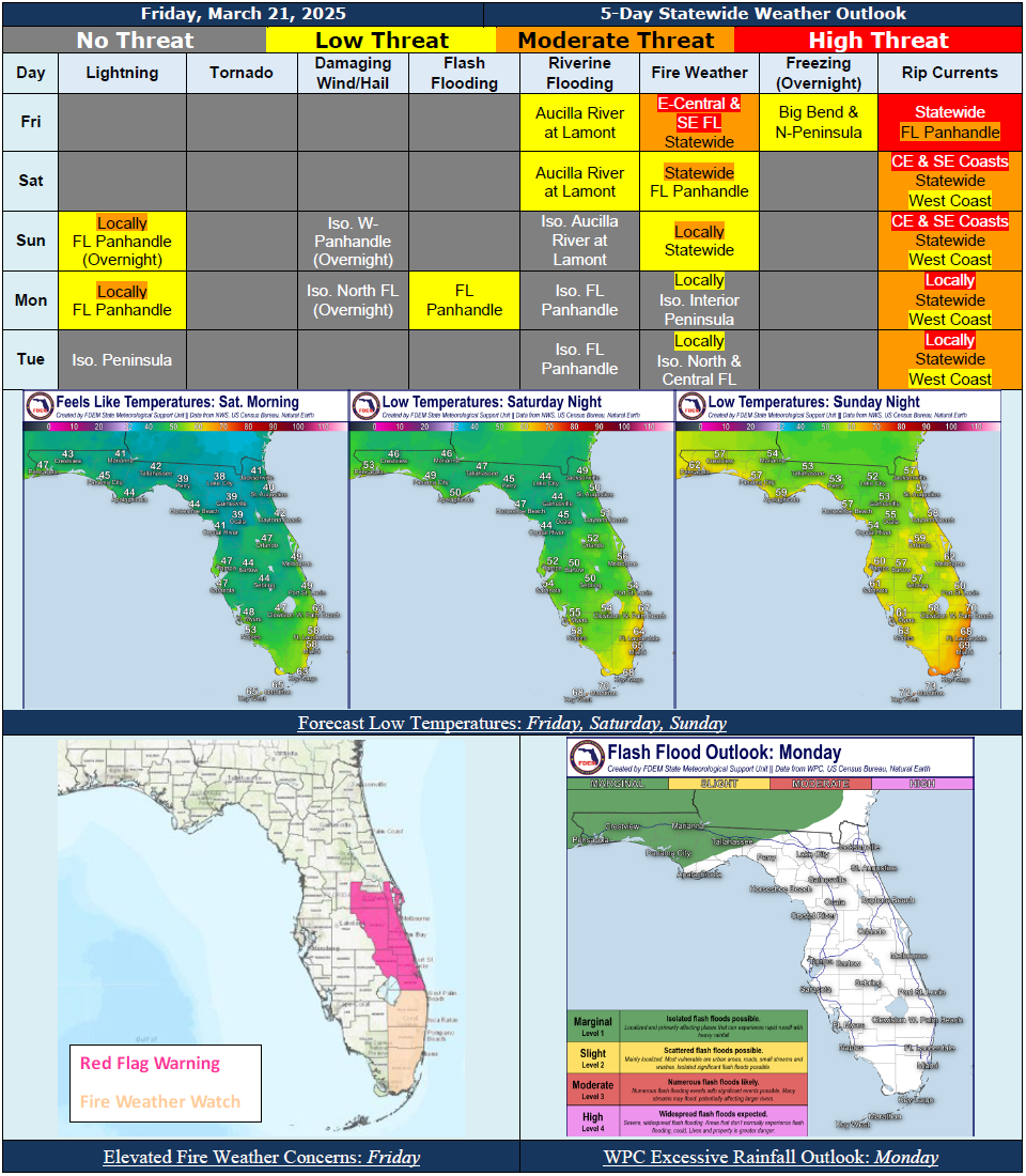
...Mostly Dry and Pleasant Conditions to Persist Statewide Throughout the Weekend…Rain Chances Return to Panhandle Sunday Night And Florida Panhandle Into the Suwannee Valley Early Next Week As the Next Frontal System Approaches and Moves Through the State…There is A Marginal Risk For Flash Flooding Across the Florida Panhandle Monday As Activity May Be Training In Nature…Mostly Dry Conditions Redevelop Statewide By Tuesday Night As High Pressure Moves Back In Behind the Frontal Boundary…Breezy Winds Near 5-10 MPH With Gusts to 15-20 MPH Expected Today; Winds Return to Near 5-10 MPH With Gusts Near 10-15 MPH Through The Rest of the Forecast Period…Dry Air Across the State Will Create Sensitive to Elevated Wildfire Conditions Statewide This Afternoon and Evening… Red Flag Warnings Issued For East-Central Florida As Critically Low Relative Humidity, Breezy Winds, Rapidly Drying Fuels, and Ongoing Drought Conditions Will Create High Fire Danger; Fire Weather Watches Extend Across Southeast Florida...Any Fires That Develop Will Likely Spread Rapidly; Outdoor Burning Is Not Recommended; Remember to Avoid Open Flames, Keep Vehicles Off Dry Grass and Properly Discard Cigarettes...Despite Weaker Winds This Weekend, Continued Dry Conditions Will Continue to Create Sensitive to Locally Elevated Wildfire Conditions Statewide…Locally Sensitive Wildfire Conditions Can Continue To Be Expected Across Portions of the Sunshine State Early Next Week…High Risk for Rip Currents Statewide Today; Moderate to High Risk Along the East Coast and Florida Panhandle Through the Weekend and Into Early Next Week…Hazardous Beach and Boating Conditions Linger With Breezy Winds and Ocean Swells Today; Relatively Calm Marine Conditions to Return This Weekend Into Early Next Week…Cool Temperatures Today to Gradually Warm Back Up Through the Forecast Period…Low Temperatures In the Middle 30s to Middle 40s Across North Florida Tonight May Allow For Areas of Frost to Develop Overnight Into Saturday Morning…
…Have A Wonderful Weekend!...