5 Day Statewide Weather Outlook for Fri 3/14 to Tue 3/18
Florida Division of Emergency Management sent this bulletin at 03/14/2025 03:40 PM EDT
This update is intended for government and emergency response officials, and is provided for informational and situational awareness purposes only. Forecast conditions are subject to change based on a variety of environmental factors. For additional information, or for any life safety concerns with an active weather event please contact your County Emergency Management or Public Safety Office or local National Weather Service forecast office.
You are subscribed to 5 Day Weather Outlook for Florida Division of Emergency Management. This information has recently been updated, and is now available.
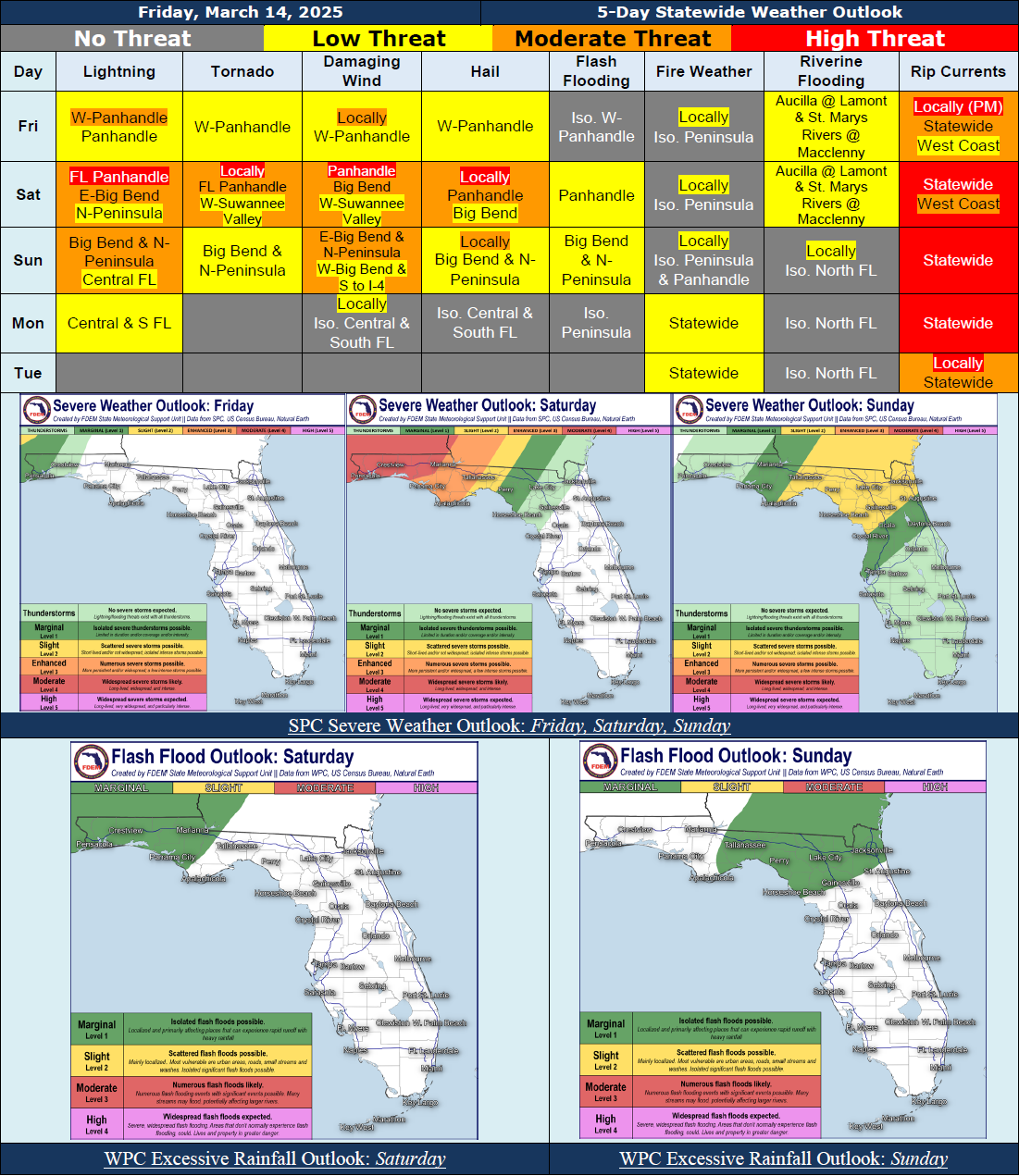
...Mostly Dry Conditions Statewide Today and Tonight With A Few Isolated Showers and Thunderstorms Along the Panhandle Overnight…Marginal Risk (Level 1 of 5) for Severe Weather Along the Western Panhandle; Gusty Winds, Hail, and Isolated Tornado Possible…Increasing Confidence for Significant Severe Weather Threat As A Line of Severe Thunderstorms Moves West to East Through the Florida Panhandle Late Saturday Into Early Sunday Morning Along and Ahead of a Cold Front (Enhanced to Moderate Risk for Severe Weather – Level 3-4 of 5); All Modes Of Severe Weather Possible, Several of Which May Be Significant (Including 70+ MPH Winds, Large 2+” Hail, and EF-2+ Tornadoes)…Long-Tracking Tornadoes Cannot Be Ruled Out…Make Sure to Have Multiple Ways to Receive Weather Alerts Overnight…The Line of Showers and Thunderstorms Will Push Further Eastward Into the Northern Peninsula and Southward Towards the I-4 Corridor Sunday Morning into the Afternoon Hours Before Breaking Apart Sunday Evening Into the Overnight Hours…Strong to Severe Thunderstorms Will Continue to Be Possible Across the Big Bend and Northern Peninsula Southward to the I-4 Corridor (Marginal to Slight Risk for Severe Weather – Level 1-2 of 5)…Locally Heavy Downpours May Result In Instances of Flooding and Ponding of Water Across North Florida This Weekend (Marginal Risk for Flash Flooding – Level 1 of 4)…Scattered Showers and Thunderstorms Will Persist Across The Peninsula Monday As the Cold Front Moves Offshore…Mostly Dry Conditions Return Monday Night and Tuesday…Breezy Winds Expected to Develop Statewide Ahead of the Cold Front This Weekend With Gusts Reaching In Excess of 20-35 MPH At Times, Primarily Along the Florida Panhandle…Hazardous Beach and Boating Conditions and A High Risk for Rip Currents Expected to Develop Statewide This Weekend, Lingering Into Early Next Week Minor Coastal Flooding May Be Possible Along Portions of the Florida Panhandle and West Coast…
…Have a Wonderful Weekend and Stay Safe!...