First Day Hikes: Safely Recreating at California’s State Parks
Story from: Justine Kardad, Partnership Division; Joseph Shanahan, Gold Fields District; Amber Sprock, Central Valley District; Tyson Butzke, Channel Coast District; Roberta Lyons, Anderson Marsh Interpretive Association; Teri Lopez, Northern Buttes District; and Rhiannon Sims, Santa Cruz District
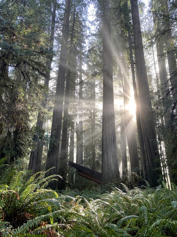
 The wind caves hike took participants through the scenic backcountry of Gaviota State Park. Participants encountered beautiful views of the Gaviota Coast and surrounding hills. Photo from Parker Grand, Channel Coast District.
It’s safe to say that the past two years have been filled with changes; however, what remains the same is the excitement that the First Day Hikes on New Year’s Day bring every year. Despite varied weather conditions on Saturday, January 1, there was still a large turnout for the guided hikes to California’s state parks. A total of 55 parks offered 83 hikes in the desert, along the coast, through snow, up mountains and through redwood forests.
-
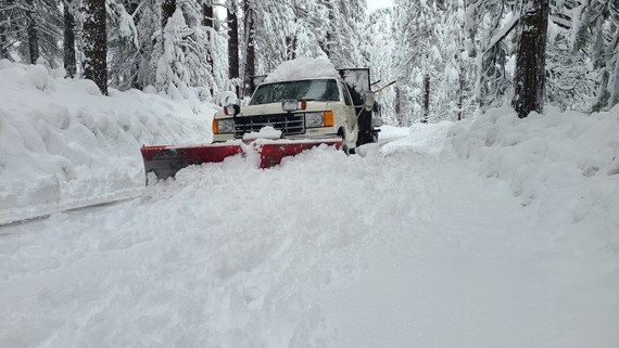
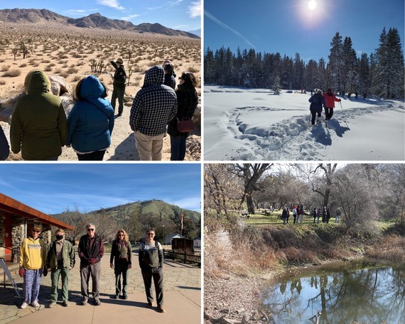
Auburn State Recreation Area (SRA): Participants braved freezing temperatures to travel an orienteering course. Hikers were given a compass and a list of controls, each with a distance and direction. At the end of the hike, all were proficient at reading maps, compasses and ended up guiding park staff. Along the hike, they saw several species of fungus, germinating buckeyes and the sheer limestone walls of Cave Valley climbing area.
-
Marshall Gold Discovery State Historic Park (SHP): The participant grand total for the park’s First Day Hike was three! One came for the Monument Hike and two for the Monroe Ridge Hike. The hikes culminated with very happy participants because of our great interpreters, Chloe Gautschi and Judy Huestis, and the individualized attention.
-
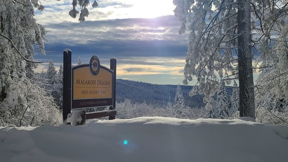
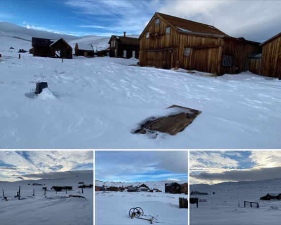
Calaveras Big Trees State Park (SP): The hike brought participants into the elements, with fresh powder on the park, and 30 people celebrated the new year by snowshoeing a portion of the iconic North Grove. Docent Nancy E. Muleady-Mecham, Ph.D., led the group of all ages on about a mile-long trek and shared how the forest community adapts to the winter. Most of the trail was well traveled, but the group enjoyed an opportunity to navigate through some deep snow. After blazing trail, the group turned back toward the Warming Hut to return snowshoes and enjoy the roaring fire.
-
Carpinteria State Beach (SB): The hike kicked-off with all hikers writing their new year’s resolutions on a poster. Most goals were health-oriented, like eating healthier and being more active. One child, however, wrote that their resolution was to drink juice straight from a coconut and that was the group favorite. Interpreter Heidi Ortloff discussed the Chumash tribe and how their Tomol building led to the name Carpinteria. They also stopped at the tar pits and hikers got to handle replica sabretooth teeth and a mastodon tooth. The tide was high, but fortunately there were about 60 harbor seals sunbathing on the small strip of beach and about 30 pelicans.
-
La Purísima Mission SHP: This First Day Hike was led by Interpretive Park Aide Randy Moore, and the weather was clear and chilly for the more than 40 hikers. Randy led the group along La Artemisia and Santa Rita Trails, finishing with a spectacular view of La Purísima Mission grounds, Lompoc Valley and Vandenberg Space Force Base. The hike traversed 1.7 miles of soft sand and included a couple of decent hill climbs through the burton mesa chaparral and scrub oak forest.
-
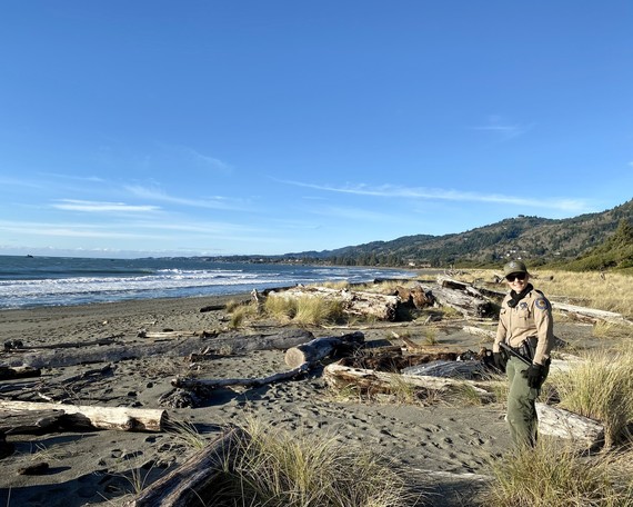
Gaviota SP: This First Day Hike was led by State Park Interpreter I Parker Grand on this sunny, crisp morning (30 degrees). A small group of participants (10-15) met at the Beach to Backcountry Trailhead for a hike to the Gaviota Wind Caves. The wind caves hike took participants through the scenic backcountry of the park. Participants encountered beautiful views of the Gaviota Coast and surrounding hills. The wind caves are a natural geological formation carved over time by the wind and salt air. As the day warmed up, more hikers arrived at the trailhead and embarked on their own trip up to the wind caves.
-
Anderson Marsh SHP: At McVicar Trail, the hike was broken up into two groups, depending on pace level. Everyone started out on the Cache Creek Trail, then either took the Anderson Flats Trail back to the main parking lot or took the Marsh Trail or the Ridge Trail, which totaled 3 miles. Former Anderson Marsh SHP ranger, Tom Nixon, attended and happily ran into Winifred (née Anderson) Lea and her family, who came to enjoy the hike. Winnie Lea is the great-granddaughter of John Still Anderson and Sarah Anderson, who purchased and moved to the ranch in 1885. The Anderson descendants lived in the original ranch house until the 1960s, when the ranch was sold.
-
Clear Lake SP: The park had nine visitors join in the First Day Hike. They enjoyed wandering along the trail and boardwalk for a mile as lead, Brad Barnwell, spoke on the birds of the area and other wildlife sightings they may have seen along the Kelsey Creek slough.
-
Natural Bridges SB: The hike had the highest attendance at a single park, with 95 hikers. On the Monarch Habitat hike, they came upon a herd of deer. A nesting pair of great horned owls were visible in the Monarch Grove. On the day of the walk, it was sunny and nice out, so butterfly clusters were very visible. Because many people wished to join the tide pool habitat walk, we decided to split the group, with an interpreter leading a multistop, more-involved walk, and two docents leading a walk just about the tide pool animals, going quickly out to the pools. There were good viewing conditions due to the extremely low tides.
-
The Forest of Nisene Marks SP: The hike had a diverse group of hikers with several docents, locals and first-time visitors. After days of rain, they were extremely lucky to have clear skies to welcome them into the forest. They had many banana slugs dotting their trail and the sound of a full creek was music to their ears. Interpreter I Ashley Wemp shared her knowledge about marine fossils, which populated the walls in the middle of the forest. She also shared her knowledge about banana slugs and some of the trains that long ago carried the logs out of the forest to market. Interpretive Park Aide Paul Karz conveyed themes of survival and renewal, sharing that redwoods as a species are over 240 million years old and that The Forest of Nisene Marks, logged over 100 years ago, has renewed itself to become a healthy second-growth forest today.
A huge thank you to park staff, docents, volunteers and partners who organized and guided the hikes. Your efforts are invaluable to making this event a success and a great way to start the new year!
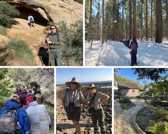 Top left: Hike at Gaviota State Park led by State Park Interpreter I Parker Grand to the Gaviota Wind Caves. Photo from Parker Grand, Channel Coast District. Top right: Hikers celebrated the new year at Calaveras Big Trees State Park by snowshoeing a portion of the iconic North Grove. Photo from Amber Sprock, Central Valley District. Bottom right: During the hike at the Monterey State Historic Park, hikers were able to enjoy the gardens. Photo from Richard Fletcher, Monterey District. Bottom middle: Two of the hike leaders Cryssie Moreno and Sara Jo Steffen from San Onofre State Beach enjoyed the warm weather while on the hike. Photo from Cryssie Moreno, Orange Coast District. Bottom left: During the hike at Silverwood Lake State Recreation Area, hikers enjoyed a family-friendly ramble from the Nature Center to the meadow. Interpreter II Teri Pope was the hike leader, and Ranger Mike Hagel and volunteers Casey Carter, Lindsay Woods and Marcos Cortes also came along. Photo from Lindsay Woods, volunteer for Inland Empire District.
 Top left: During Saddleback Butte State Park First Day Hikes, hikers were able to choose from three different hikes, including a strenuous 5-mile hike up the Butte. Photo from Jean Rhyne, Great Basin District. Top right: At Donner Memorial State Park, hikers participated in a snowshoe tour. Photo from Jeremy Lin, Sierra District. Bottom right: Clear Lake State Park’s First Day Hikers enjoyed wandering along the trail and boardwalk. Photo from Bob Schoenherr, volunteer at Northern Buttes District. Bottom left: Marshall Gold Discovery State Historic Park First Day Hikers (left to right): Visitor Cathi Gunn, Park Aide Chloe Gautschi, visitor Mike Bagnall, Park Aide Judy Huestis and visitor Tim Kendall. Photo from Susan Okey, Gold Fields District.
Santa Cruz District Cultural Resources Program Fully Staffed
Story and photo from: Mark Hylkema, Santa Cruz District
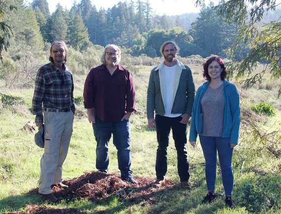 Santa Cruz District Cultural Resources Program team: Left to right: Mark Hylkema, Martin Rizzo, Michael Grone and Jenny Daly (Henry Cowell Redwoods State Park).
For the first time, the Santa Cruz District Cultural Resources Program is fully staffed, and we are pleased to report that our team is immediately engaged with numerous tasks, including from rebuilding Big Basin State Park; partnering with Native American communities; supporting academic research, collections scoping and inventory, archaeological investigations and historic preservation; and interacting with our other district programs.
Our team is composed of specialists with extensive professional experience and includes myself, Program Supervisor Mark Hylkema, M.A., R.P.A.; Museum Curator I Jenny Daly, M.A.; Historian II Martin Rizzo, Ph.D.; and Associate State Archaeologist Michael Grone, Ph.D.
Thanks to the determination of our District Superintendents Chris Spohrer and Jordan Burgess and their motivation to see the Cultural Program rise to its full potential, we now can address the many—and sometimes monumental—tasks involved with stewarding, stabilizing and interpreting the vast array of cultural resources within our charge.
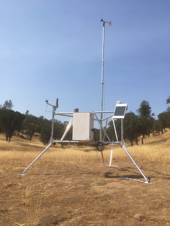
Henry W. Coe State Park Installs New Remote Automated Weather Station to Inform Park Visitors and Resource Management
Story and photos from Chris Weske, Diablo Range District
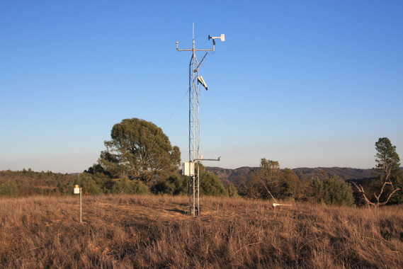 Cordoza Ridge Remote Automated Weather Station.
On Sept. 13, 2021, Henry W. Coe State Park’s second Remote Automated Weather Station (RAWS) began transmitting weather data. The new Orestimba Creek station, located at an elevation of 1,345 feet on the eastern side of the park, was funded jointly by California State Parks and the park’s cooperating association, the Pine Ridge Association. The station was installed by the California State University, San Jose, Wildfire Interdisciplinary Research Center, Fire Weather Laboratory.
The park’s first RAWS was installed in December 2011 on Cordoza Ridge, across Soda Springs Canyon from Manzanita Point. The Cordoza station was funded and installed by the California State University, San Jose, Fire Weather Laboratory. CAL FIRE assisted with some funding for the Cordoza station.
The data from these stations is available to the public on the Pine Ridge Association website, www.coepark.org, as well as on the websites of San Jose State Fire Weather Laboratory, the National Weather Service, and MesoWest. With the Cordoza station on a ridgetop at 2,331 feet and the Orestimba station in drainage at 1,345 feet, park visitors will be able to plan for the, at times, dramatic temperature differences they can encounter while spending time in the park. These stations will also be a part of the National Fire Danger Rating System, with data available through the Weather Information Management System. This information will enhance the ability to plan and conduct prescribed burns in the park and will also help deal with the threat of wildfires.
These weather stations are examples of multiple agencies and a nonprofit association working together for the public benefit—in this case, visitors to the park.
 Orestimba Creek Remote Automated Weather Station.
California State Parks Pink Bear Program Helps Raise Funds to Support Breast Cancer Research
Story from Mike Lynch, California State Park Rangers Association
Since 2018, California State Parks has helped raise money for breast cancer research every October, through the Pink Bear Program, which highlights National Breast Cancer Awareness month. As part of the program, California State Parks staff are officially authorized to wear pink bear patches and pins on uniforms for the month of October. The Pink Patch Project is a nationwide program where public agencies produce pink versions of their patches for National Breast Cancer Awareness Month to help further breast cancer prevention, treatment and research.
Supported by the California State Park Rangers Association, the Ranger Foundation, the California State Park Anniversary Committee, and the State Park Peace Officers Association of California, last year State Parks was able to raise $3,025 in from sales and donations, all of which will be donated to the Breast Cancer Research Foundation (BCRF).
A special thanks to Stellarvue, owned by retired ranger Vic Maris, for a $1,000 donation to the Pink Bear project. The California State Park Rangers Association and the California State Parks Anniversary Committee directly funded the cost of producing and mailing all pink bear patches and pins so that 100% of all sales are donated to BCRF.
Since 2018, the Pink Bear Program has raised $15,520 in donations to BCRF, and we are glad to say that the Pink Bear program will continue in 2022.
|
Hollister Hills State Vehicular Recreation Area Gets Mural Boost
Story from: Kaelin O’Hare, Diablo Range District
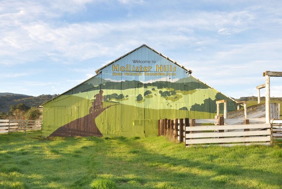 The newly completed mural located on a barn at Hollister Hills SVRA. Photo from Elise Fleishman, Diablo Range District.
For the past 30 years, a large mural has welcomed visitors to Hollister Hills State Vehicular Recreation Area. Located on the front of a barn, the original mural, painted in the early 1990s, served to greet visitors and reassure them that they had found the park.
In November last year, two members of the Hollister Hills Interpretation team, myself and Interpreter I Elise Fleishman, finished painting a brand-new mural in this same location. The old mural was faded and peeling and needed to be redone. The process started in June with the removal of the old mural via power washing, sanding and scraping. The barn was then primed, and a new design was transferred with a projector at night. When it was time to paint, two all-staff painting days helped complete the literally enormous project, which was approximately 30-feet tall and 60-feet wide. It was a “barn” good time.
The mural’s new design I created honors the old by highlighting the landscape and, additionally, celebrates the different user groups and natural history of Hollister Hills. Can you spot the all-terrain vehicle rider, horseback rider, hikers and truck in the mural?
Today, the barn stands fully painted, varnished and ready to greet and guide the public for years to come.
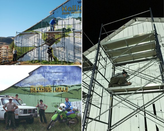 Top left: Volunteers Sarah Haviland-Moir and O’Shea O’Mary and Diablo Range District Superintendent Eddie Guaracha lend a hand, painting during an all-staff painting day. Right: Interpreter I Elise Fleishman works during the night to trace the new design onto the barn using a projector. Bottom left: Left to right: Photo taken in the early 1990s, Peace Officers Jared Ashton, Linda Davis, Mitzi Eastman and Morgan Zeitler pose in front of the original mural, not long after it was first painted. Photos from Elise Fleishman, Diablo Range District.
  Email photos to the WeeklyDigest@parks.ca.gov.

|