|
Dear Fourth District Residents,
A powerful storm is moving through San Bernardino County, bringing the region’s strongest storm since March of last year. The National Weather Service (NWS) said the heaviest rainfall is expected today, Thursday, February 13, with showers continuing into Friday. The heavy rainfall may lead to hazardous flooding in low-lying areas, rivers, and creeks. Burn areas, particularly near the Line Fire and Bridge Fire burn scars, are at increased risk of debris flows.
San Bernardino County emergency responders are working around the clock, monitoring the rainfall and the effect it is having on our roads and scorched watershed, and are poised to take action if the need arises.
San Bernardino County Fire stations have sandbags available to residents on a first come, first served basis. For more information or to find a location near you, please visit the San Bernardino County Fire website.
Please take the necessary precautions to protect your family, pets, and property during these weather conditions. Stay safe and thank you for your continued vigilance in keeping our communities safe.
- For your safety, please do not drive into flooded areas.
- Drive cautiously - heavy rain can cause flooding and low visibility.
- Secure outdoor items ahead of gusty winds.
- Keep an eye out for changing road conditions, especially in higher elevations.
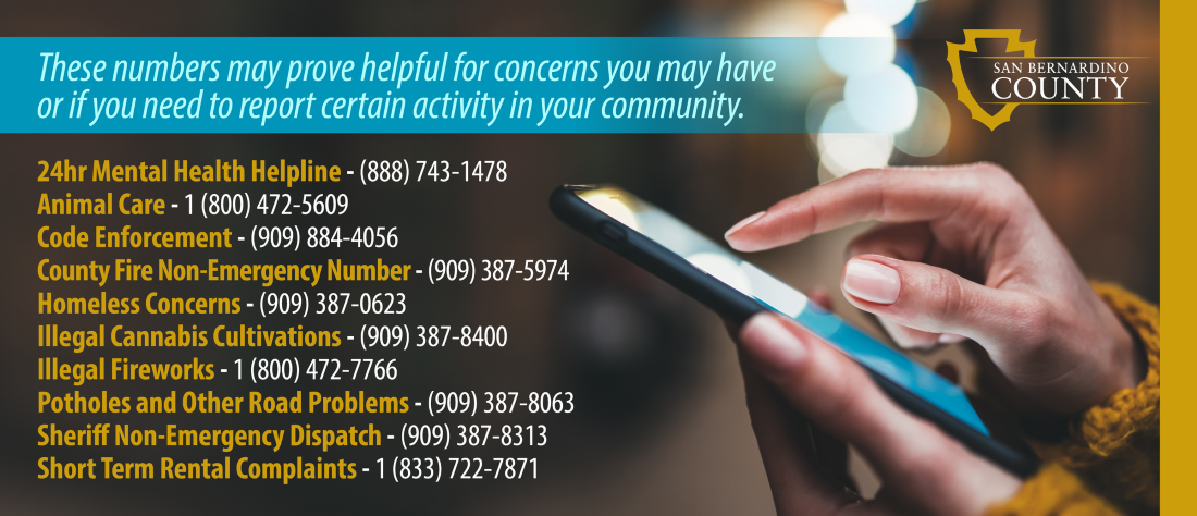
For more information or tips, please visit our resource page.
Stay Safe,
Supervisor Curt Hagman
This section focuses on family-friendly events that are happening in the Fourth District and Countywide.
|