|

July 2026
Join Placer County and the National Weather Service to learn about Fire Weather 101.
Hear from CAL FIRE Nevada-Yuba-Placer Unit / Placer Fire Department regarding an overview of the NEU Fire Plan.
The Fire Safe Alliance meeting is July 16 at 6 p.m. via Zoom.
Online only: Zoom registration

Wildfire season in Placer County is shaped as much by the weather as by the landscape, and few people understand that connection better than the forecasters who track it.
In this edition, we sat down with National Weather Service Sacramento Incident Meteorologist Katrina Hand for a conversation about the fire weather that defines our region—from Red Flag Warnings and north wind events to dry lightning and the outlook for the season ahead.
If you'd like to go deeper, the National Weather Service will present "Fire Weather 101" at the upcoming Fire Safe Alliance meeting on July 16 at 6 p.m., available via Zoom. We hope you'll join us.
1. What's the difference between a Fire Weather Watch and a Red Flag Warning, and what should Placer County residents actually do differently when one is issued?
HAND - These products are issued by the National Weather Service for events when critical fire weather conditions are expected, and fuel conditions are receptive to ignition and spread. To explain the difference between these products, we often use the metaphor of making a taco.
A Fire Weather Watch represents the individual taco ingredients; it is issued ahead of time to communicate that conditions are coming together and a taco is possible, meaning people should prepare for critical fire weather conditions.
A Red Flag Warning is the fully assembled taco; it is issued closer to the event when confidence is high that conditions are imminent or already occurring, meaning people must take action.
Avoiding burning, having an emergency plan, being conscious of creating sparks on dry fuels, reporting smoke, and listening to local authorities are some of the ways people can practice fire weather safety during these conditions.
2. Placer County stretches from the valley floor up into the Sierra. How does our terrain shape local fire weather, and are there particular wind patterns or "danger zones" residents should understand?
HAND - Terrain plays a large role in the weather and can make forecasting much more complex. One of the most common critical fire weather patterns for northern California is the “north wind” or “offshore wind” event.
This pattern is most common in the shoulder seasons, but we can observe it year-round as well. Under this pattern, Placer County may see strong north to east winds develop, along with very dry conditions and low humidity.
When fuels are receptive, this pattern can create a favorable burning environment where any fire start could spread rapidly. We can also see critical fire weather conditions ahead of cold fronts, or when we have stronger onshore flow from the southwest, especially over the ridge tops.
Thunderstorm winds can also produce strong, gusty and erratic outflow winds, which is another critical fire weather pattern that can impact Placer County.When canyons in the Sierra Nevada align with these winds, they can become channeled and enhanced, or produce eddying effects.
3. When an IMET deploys to a wildfire, what are you watching for hour to hour, and how do your forecasts change how firefighters are kept safe on the line?
HAND - Incident Meteorologists (IMETs) are specially trained “boots on the ground” fire weather forecasters that deploy to incidents such as wildfires to keep the firefighters safe and support the Incident Management Teams.
IMETs are constantly monitoring all things fire and weather when it comes to a wildfire, using tools such as satellite, radar, observations, and having eyes on the sky.
The forecasts that IMETs provide are used by the Incident Management Teams to make decisions in their operations, planning and firefighting tactics. IMETs monitor for changes in the forecast such as wind shifts, pyrocumulonimbus development, and thunderstorms, providing updates to the crews and team as needed.
4. Dry lightning has started some of California's most destructive fires. How do you forecast lightning risk, and what makes a "dry" thunderstorm so dangerous here?
HAND - Forecasting lightning can be challenging, especially in the summertime when we get into patterns where monsoonal moisture moves in from the south.
One of the most helpful tools for a Meteorologist is pattern recognition. Identifying patterns where we have seen lightning in the past can give us a general idea 7 days or so in advance if lightning may be a threat.
Closer to the event, high-resolution models, probabilistic guidance and observations are used to increase confidence on when and where lightning is expected. A dry thunderstorm is a thunderstorm that does not produce wetting rain.
This can be especially hazardous in the summertime when fuel conditions are very dry and receptive to ignition.
Dry thunderstorms can cause new ignitions and also produce strong and gusty outflow winds that can lead to rapid spread of fire.
Even wet thunderstorms can be a hazard for fire weather, because lightning can strike outside of the main precipitation core and lead to new fire starts.
5. With the season ahead of us, what does the current outlook look like for Placer County, and what's the one weather-related habit you wish every resident would adopt?
HAND - The NWS Climate Prediction Center probabilistic outlook is favoring above-normal temperatures, and equal chances for above- or below-normal precipitation for Placer County this summer.
The Northern California Geographic Area Coordination Center Predictive Services anticipates above-normal significant fire potential for July through September.
Residents should plan ahead and pay attention to weather forecasts and alerts from trusted sources.
I wish every resident would have a “Go-Bag” or emergency supplies kit prepared in case a fire starts nearby.
A few of the recommended items for a good kit would be flashlights, batteries, non-perishable food, water, important documents and a first aid kit.
For additional resources on building anemergency kit, visit www.readyplacer.org.
Placer County has been named a Fire Risk Reduction Community by the California Board of Forestry and Fire Protection, a state designation that recognizes that a community meets California’s high standards for wildfire prevention and planning.
The designation carries a direct benefit for residents. California now requires insurers to account for a Fire Risk Reduction Community designation when they set rates, meaning the reduced wildfire risk in the covered area must be reflected in premiums.
Homeowners and business owners are encouraged to call their insurance provider, mention the designation, and ask how it applies to their policy.
Discount amounts vary by insurer and by property, so homeowners should contact their provider to confirm whether the designation applies to their policy. The designation also strengthens the county’s position when applying for CAL FIRE wildfire prevention grants.
That funding supports work that lowers risk — thinningovergrown brush and small trees, building and maintaining fuel breaks along ridge lines and evacuation routes, clearing roadsides, chipping programs and wildfire planning.
Placement on the state’s list reflects a rigorous review of how the community plans for and reduces wildfire risk, and the county’s sustained investment in forest health and wildfire resilience — from landscape-scale restoration to defensible space close to home.
To learn more about the Placer County Regional Forest Health Division, please visit www.placer.ca.gov/forests.
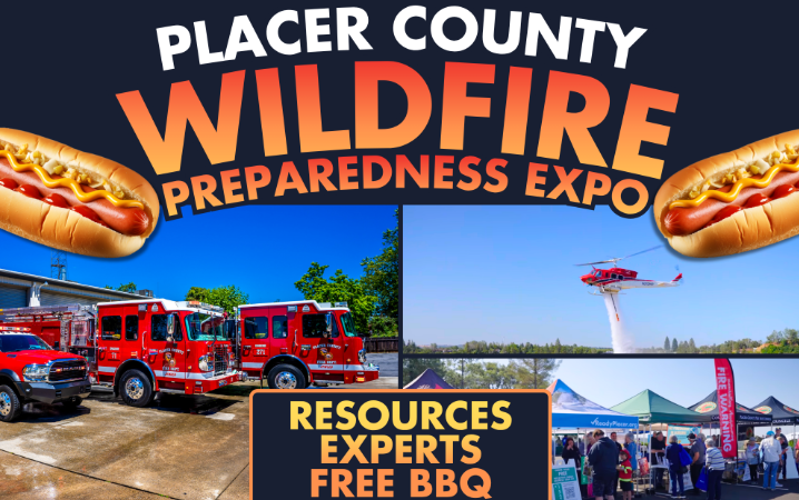
CAL FIRE NEU/Placer County Fire is hosting the Wildfire Preparedness Expo on July 11 from 8 a.m. to noon at Fire Station 10, 13760 Lincoln Way in Auburn.
Learn about home hardening tips and resources, local Fire Safe Councils, the Firewise USA® Community Program, and emergency preparedness and evacuations.
Observe fire rescue equipment displays and tour the fire station open house. Bring the kids and stay for the free BBQ.
Date/Time: July 11, from 8 a.m. – 12 p.m.
Location: CAL FIRE NEU/PCFD Fire Station 10, 13760 Lincoln Way, Auburn
Learn more: www.placer.ca.gov/wildfireexpo
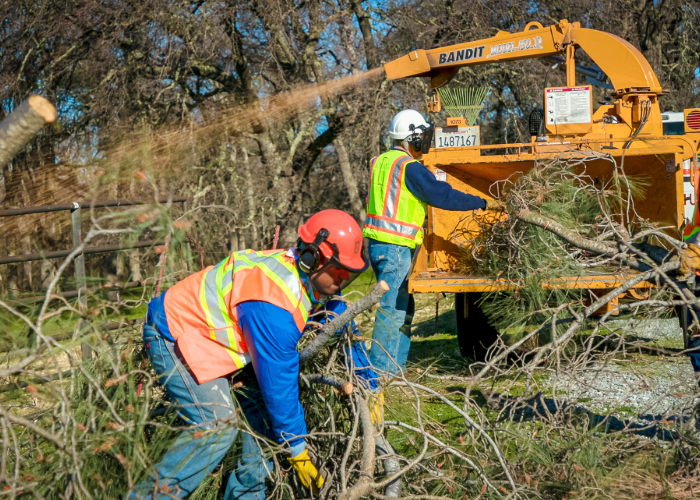
Placer Resource Conservation District offers the Placer County Chipper Program, which is a cost-share program funded by Placer County and CAL FIRE that provides low-cost residential chipping for county residents, incentives fuel reduction, and promotes defensible space adherence and fire prevention activities.
For $80 per hour, a crew will chip and broadcast piled vegetation. Cost-share fees may be waived for landowners who have a household income not exceeding the “very low limit” as defined by the State of California Department of Housing and Community Development.
Questions?: Please email chipper@placerrcd.org or call 530-390-6680
Learn more: www.placerrcd.org/programs/chipperprogram
Disclaimer: The Placer County Chipper Program only serves addresses within the Placer Resource Conservation District service area. It cannot serve addresses within the Tahoe Regional Planning Agency jurisdiction.
The TRPA jurisdiction includes, but is not limited to, the communities east of Alpine Meadows like Tahoe City, Kings Beach, Dollar Point, Tahoe Pines, Homewood and Meeks Bay.
To schedule chipper service within TRPA jurisdiction, please visit the North Tahoe Fire Protection District.
Learn more: www.ntfire.net/chipping-program

By Kelsey Stalker, Fire Adapted Communities Program Assistant at the Tahoe Resource Conservation District
It’s summer in Tahoe after a historically low snowpack winter. It’s not time to panic; it’s time to ask ourselves: what’s my home hardening strategy?
When preparing for wildfire, we need to remember that fire is a natural part of the ecosystem.
This is why Land Managers use prescribed fire during windows with safe conditions to do so. Prescribed fire transforms forest clutter into carbon-rich soil using strategy and control, creating healthy space and habitat in Tahoe’s forests.
However, the threat of wildfire significantly increases once we get to summer weather and drier conditions. When the risk is too high for prescribed fire, agencies focus their efforts on fighting wildfires and continuing mechanical fuel treatments when possible. With limiting resources to prevent and fight wildfires, it is up to residents to adapt to living with fire – starting at home.
Ember-Resistance is Key
Wildfire research has recognized embers as one of the major causes of loss of residential structures in Wildland Urban Interface (WUI) communities (Nazare et al., 2021).
Another study with the National Institute of Standards and Technology discovered that during fires in the WUI, most structures are bombarded by ember showers (Manzello et al., 2002).
These findings, and more, have shown how effective it is to make improvements (or retrofits) to homes to improve their ember resistance.
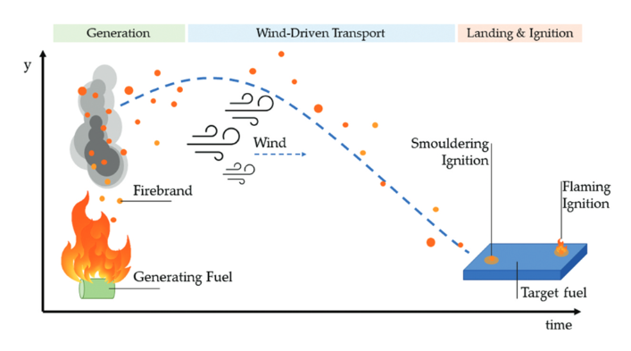 The figure above displays how firebrand (ember) behavior causes spot fires (Gellerman & Chien, 2023).
As seen above, embers are known to cause spot fires on the ground, as well.
Spot fires can turn into larger fires with enough fuel, oxygen, and heat. This is why we create fire defensible space and remove or reduce the fuel that could ignite other vegetation or structures.
These types of fuel are referred to as ladder fuels, defined as live and dead vegetation that bridge the gap between the surface and the canopy.
The presence of ladder fuels often turns low-severity surface fires into high-severity canopy fires, which can pose great risks to communities in the WUI (Menning and Stephens, 2007; Ottmar et al., 2007).
Applying the Science
Understanding the science behind wildfire risk can be overwhelming on its own. Add on evacuation planning and just living our lives, it can seem impossible to be fully prepared. The good news? There are simple steps proven to help reduce wildfire risk in WUI communities.
Home Hardening:
- Remove lattice and debris from below \and around decks
- Replace vent mesh with 1/8 inch mesh/screen
- Install ember-resistant materials in 0-5 foot zone, such as gravel
- Screen chimneys with spark arrestors
- Remove or replace wood fencing within 5 feet of the house
Defensible Space:
- Clean up pine needles and cones
- Remove debris beneath decks
- Move woodpiles 30 feet away from your structure
- Clear pine needles from roofs and gutters
- Ensure dead plant debris in the 0-5 foot zone is removed/cut back
Before wildfire gets to your neighborhood, take some time to think about your home hardening and defensible space strategy.
Walk around your home and look for ways embers could get in and accumulate. Notice which plants could be ladder fuels and where combustible pine needles and cones tend to pile up.
Once these risks are identified, take action to address them as soon as possible. Schedule a defensible space inspection with your fire district, talk to your neighbors, learn more about wildfire, and remember that being wildfire prepared requires a multi-faceted approach.
For more information on how to prepare for wildfire and events in the Tahoe region, visit www.tahoelivingwithfire.com.

Join Firewise Community Virtual Office Hours via Zoom on the first Thursday of every month, 9 to 10:30 a.m.
For more information regarding the Firewise Program, visit www.placer.ca.gov/Firewise or contact fireready@placer.ca.gov, or call 530-886-FIRE (3473).
Are you passionate about protecting your community from wildfire?
Placer County Fire Safe Councils are seeking new members! Fire Safe Councils are community-based groups that help reduce wildfire risk through education, outreach, and local action.
As a council member, you’ll collaborate with neighbors, local fire departments, and Placer County’s Office of Emergency Services to make our community safer and more resilient.
The following Fire Safe Councils have openings:
- Greater Auburn Area Fire Safe Council
- North Auburn Ophir Fire Safe Council
- Placer Sierra Fire Safe Council
Council members:
- Attend and participate in regular meetings
- Support community clean-up and defensible space projects
- Help engage the public through outreach and events
- Uphold transparency and ethical standards in local wildfire preparedness
How to apply
- Complete the application form.
- Submit your completed application to the Clerk of the Board of Supervisors for consideration.
Applications must be fully completed and sent to:
Clerk of the Board of Supervisors
175 Fulweiler Avenue, Room 101Auburn, CA 95603
BoardClerk@placer.ca.gov
Questions? Contact us: fireready@placer.ca.gov, 530-886-FIRE (3473)
By Ryan Ochoa
Congratulations to Serene Lakes Firewise Community residence that earned the extra recognition of IBHS Wildfire Prepared Home Designation! Read more
Placer West Fire Safe Council Meeting, July 1, 5:30 p.m. Information
Virtual Office Hours - Firewise USA Program, July 2, 9-10:30 a.m.Information
Wildfire Preparedness Expo, July 11, 8 a.m.-12 p.m. Information
Placer County Fire Safe Alliance Meeting, July 16, 6 p.m. Information
Greater Auburn Area Fire Safe Council Meeting, July 17, 9 a.m. Information
Foresthill / Iowa Hill Fire Safe Council Meeting, July 21, 5:30 p.m. Information
Placer Sierra Fire Safe Council Meeting, July 23, 6 p.m. Information
North Auburn Ophir Fire Safe Council Meeting, July 28, 4 p.m. Information
Placer West Fire Safe Council Meeting, August 5, 5:30 p.m. Information
Virtual Office Hours - Firewise USA Program, August 6, 9-10:30 a.m. Information
Foresthill / Iowa Hill Fire Safe Council Meeting, August 18, 5:30 p.m. Information
Greater Auburn Area Fire Safe Council Meeting, August 21, 9 a.m. Information
North Auburn Ophir Fire Safe Council Meeting, August 25, 4 p.m. Information
Placer Sierra Fire Safe Council Meeting, August 27, 6 p.m. Information
|