The Southern Marin Scoop
JANUARY 7-14: HIGH TIDES &
MANZANITA PARK-AND-RIDE CLOSURE
Please Share Widely:

Plan ahead! Over the next week or so, we can expect to see high tides and road flooding in Southern Marin. If you live near or drive through Manzanita at the gateway to Tam Valley - or know someone who does - please help us spread the word!
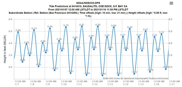
Based on tide predictions published by the National Oceanic and Atmospheric Administration (NOAA), tide levels January 9-14 are expected to be high enough to cause roadway flooding in parts of Marin, primarily coastal areas. Drivers are encouraged to consider using alternative routes and should allow extra time for trips, especially during peak commute times. Travelers should always avoid driving through ponded water, as even six inches of standing water can stall a low-clearance car.
| Day |
Time |
Tide Prediction |
| Friday, Jan. 8 |
6:59am |
6.19 |
| Saturday, Jan. 9 |
7:47am |
6.48 |
| Sunday, Jan. 10 |
8:35am |
6.70 |
| Monday, Jan. 11 |
9:24am |
6.81 |
| Tuesday, Jan. 12 |
10:12am |
6.80 |
| Wednesday, Jan. 13 |
11:00am |
6.66 |
| Thursday, Jan. 14 |
11:47am |
6.40 |
| Friday, Jan. 15 |
12:32pm |
6.01 |
In anticipation of flooding, Caltrans has scheduled a partial closure of the lower half of the Manzanita Park-and-Ride Lot, as well as off-road parking spaces along the shoulder of Highway 1, from January 7-14. This closure is a precautionary measure to eliminate the possibility of vehicles flooding and getting damaged by the water.
Often during anticipated flood events, Caltrans will display a real-time camera image of the Manzanita lot/signal so people can see what's happening in that area before deciding what route to take. To see the video, visit http://quickmap.dot.ca.gov/. Click the QuickMap "Options" menu and then check the box next to "Cameras." On the map, zoom into the Tam Valley area and click on the little blue video camera icon.
Additional Caltrans informational resources include their District 4 (Bay Area) website and Facebook and Twitter accounts. Follow/subscribe for updates!
Travelers can also check 511.org for the latest traffic and transit information. Marin County Department of Public Works (DPW) Twitter, Marin County Sheriff’s Office Twitter, the California Highway Patrol (CHP) traffic website and CHP Marin Twitter are excellent resources for travelers and residents looking for updates during storm events. Additionally, weather gauges showing rainfall and tide elevations can be viewed in real-time at Marin County’s OneRain webpage.
If you have a question or concern and would like to contact me, please send an email to me or one of my Aides using the links on my webpage: marincounty.org/depts/bs/district-3/home.
For information on the County of Marin's response to the COVID-19 pandemic, please visit coronavirus.marinhhs.org. You can also contact the COVID-19 Response Team with your questions and concerns at coronavirus.marinhhs.org/contact.
|