Update from Kate
TIME TO GET READY: HIGH TIDES EXPECTED NOV. 13-18
WITH BACKGROUND ON SEA LEVEL RISE WORK
IN AND AROUND MANZANITA AND THE CALTRANS PARK & RIDE
Please Share Widely:

It's that time of year again: we need to pay attention to the tides! Seasonal high tides start showing up in November and last into the winter, sometimes combining with rainfall and storm surge. Currently, high tides are anticipated this Friday, November 13 through Wednesday, November 18.
Southern Marin, with beautiful views of the bay and coastal marshland, is particularly susceptible to flooding that impacts our local roadways. One area of interest to many is along Route One/Shoreline Highway and the Manzanita Park & Ride under Highway 101, which floods regularly during high tides, limiting parking and at times stranding and swamping vehicles. Let's not get caught this year.
The area mentioned above is one where we are already seeing the impacts of climate change and sea level rise. Addressing sea level rise generally -- as well as specifically at Manzanita Park & Ride -- is something we have been working on diligently during my time as Supervisor. Flooding in this area is and has been a source of concern for the community, and I often receive questions from constituents about what we are doing to respond.
Please read on for a bit of local flooding history, accompanied by what you need to know now:
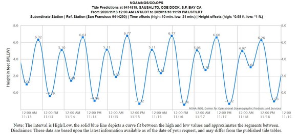 Above: Tide chart for Sausalito from November 13-18. Tides will be similar along the Mill Valley shoreline and in surrounding areas.
Do you live near or drive through Manzanita at the gateway to Tam Valley, or know someone who does? Help us spread the word!
Based on tide predictions published by the National Oceanic and Atmospheric Administration (NOAA), tide levels November 13-18 are expected to be high enough to cause roadway flooding in parts of Marin, primarily coastal areas. Drivers are encouraged to consider using alternative routes and should allow extra time for trips, especially during peak commute times. Travelers should always avoid driving through ponded water, as even six inches of standing water can stall a low-clearance car.
Often during anticipated flood events, Caltrans will display a real-time camera image of the Manzanita parking lot / signal so people can see what's happening in that area before deciding what route to take. To see the video, visit http://quickmap.dot.ca.gov/. Click the QuickMap "Options" menu and then check the box next to "Cameras." On the map, zoom into the Tam Valley area and click on the little blue video camera icon.
Travelers can also check 511.org for latest traffic and transit information. Marin County Department of Public Works (DPW) Twitter, Marin County Sheriff’s Office Twitter, the California Highway Patrol (CHP) traffic website and CHP Marin Twitter are excellent resources for travelers and residents looking for updates during storm events. Additionally, weather gauges showing rainfall and tide elevations can be viewed in real-time at Marin County’s OneRain webpage.
Also, flooding is anticipated December 11-17 and January 8-14, so be sure to mark those dates on your mobile device or home calendars so you remember to tune in to local forecasts and the resources above!
Sea level rise, and the flooding it brings to our communities, has been a significant focus for me ever since I became County Supervisor in 2011. In 2013, I launched a Southern Marin Pilot Project to examine how the climate change impacts of sea level rise and storm events affect the future of Southern Marin communities, infrastructure, ecosystems, and economy. That project was a first foray for many of us into cataloguing and mapping assets and assessing vulnerabilities to sea level rise. It was also a first step in engaging and educating the community about the impacts of sea level rise and what to do about it.
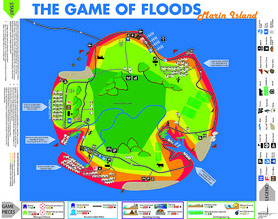
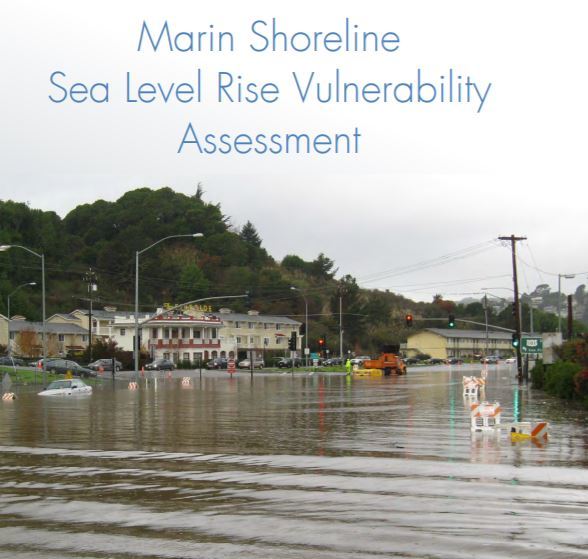
We have come a long way since then, creating the award winning Game of Floods, which teaches players about adaptation choices, and launching BayWAVE, which completed a Sea Level Rise Vulnerability Assessment for Marin’s bay shoreline in 2017 (see this helpful PPT overview) and is working with local cities and towns to plan implementation of adaptation strategies. We have continued the good work of C-SMART for adaptation planning on the Marin coast, linked analysis of watersheds and shorelines so we can get a complete picture of the movement of water and flooding, and launched Drawdown: Marin to dramatically reduce the greenhouse gas emissions that drive climate change. And, with the One Tam team, we developed the Evolving Shorelines Project at Bothin Marsh -- to name just a few of the County’s projects and initiatives.
|
 Through all of this science-based study and analysis, we have developed a keen sense of the complexities of adaptation options and the financial challenges to implementing adaptation projects. We are also keenly aware of the need for public engagement and awareness so that we can move forward together on solutions.
Yet, in spite of all of this good work, it sometimes feels like we have made little progress in conveying a sense of urgency about sea level rise in a way that galvanizes the kind of action we need to take if we are to adapt to our changing world. Our experience of frequent flooding in and around the Manzanita/Pohono area is an ongoing call to address immediate and short-term sea level rise impacts even if we cannot yet solve for the long term. Sometimes it takes an emergency to focus attention, broaden awareness, and create the financial support necessary for taking action. Given how rapidly ice is melting and ocean temperatures are rising, we may have an emergency on our hands sooner than we think.
Please consider subscribing to all of the above websites to receive updates when new information is posted, including community events. We need your help spreading the word about this important work!
The Manzanita Park & Ride area is a topic of continuing conversation, particularly during winter storms and flood events. I've shared information in my e-newsletters over the years, and it seems like an opportune time to offer this background information again, as well as updates on the progress to-date.
A Bit of Background
Reality Check: Shoreline Highway - A State Highway
Route One/Shoreline Highway is owned and managed by the California Department of Transportation (Caltrans). With miles of our own roads to maintain, the County of Marin is unable to spend our roadway funds on the State highway system. However, we serve as a liaison to convey issues to Caltrans staff. My office works closely with our County Public Works staff who have ongoing communication with their counterparts at Caltrans, referring questions and problems to the proper person for assistance and resolution.
But just because we don’t own the roadway doesn’t mean we don’t do anything to improve its maintenance and functionality. In fact, we do quite a bit of wrangling with other agencies and organizations.
Ongoing Flooding: Marin County Flood Control District Has A Role
On our local tax bills, those of us living in Southern Marin in Flood Zone 3 fund an agency called the Marin County Flood Control District on which I serve along with the other Marin County Supervisors. Zone 3 was formed in 1956 to address creek and tidal flooding adjacent to Richardson's Bay and is overseen by a 7-member Advisory Board.
Zone 3, known as Richardson's Bay, covers over 13 square miles, including the City of Mill Valley and numerous unincorporated communities including Marin City, Alto-Sutton Manor, Almonte, Tamalpais Valley, Homestead Valley, and portions of Strawberry Point.
With Flood Control Zones established throughout the County of Marin, we use proceeds from this pool of money to fund local flood control projects. There are established Flood Control Zone Advisory Boards for each one of the zones that help advise the District on how this funding should be spent. Flood Control District staff at the County of Marin help design, build, and manage flood control facilities (like pump stations and flood gates) and projects at various locations.
Marin County Flood Control Work in Manzanita
In late 2016, Marin County Flood Control District staff took the lead in constructing a temporary sand bag wall along the west side of the Richardson Bay Bridge, next to the Caltrans yard (the western side drainage) to reduce direct tidal flooding along Shoreline Highway. In 2017, District staff rebuilt the wall in time for the first round of King Tide flooding in November and December.
In late 2017, Caltrans installed over $1M of system improvements to drainage facilities in the Manzanita area to reduce flooding, including a new tide gate on the drainage inlet from Shoreline Highway, as well as two new tide gates along the east side of the Richardson Bay Bridge (the eastern side drainage channels). Both of these drainage systems regularly overtopped during the King Tides resulting in roadway flooding even under sunny day conditions.
The Road Ahead Toward Long-Term Solutions
We are working collaboratively across public agencies to identify measures we can take now and in the near term to alleviate flooding at these known “hot spots” where frequent flooding occurs. The reality is that the longer term fixes are complex, capital-intensive infrastructure projects. These kinds of projects take years to design, present for public input, fund, obtain state and local agency permits, and then build.
We don’t yet have all the answers for Manzanita but we’re taking all the short and medium term steps we can to better understand the local context and how these smaller projects work and work together. It’s by taking these important incremental steps that we both learn how best to address local flooding and also build strong institutional relationships. We are building relationships with Caltrans, elected leaders in local agencies, the business community, and local residents so we will be ready to pursue the more complex, longer term solutions we need.
Key Updates
There are 3 key studies you should know about that affect the Manzanita and Bothin Marsh areas. We’ve had great success bringing agencies together and garnering funding to look at options here:
-
Underway: The One Tam project (a multijurisdictional collaboration by many public agencies) called Evolving Shorelines, covers Bothin Marsh, the bay shoreline, the Mill Valley-Sausalito Multi-Use Pathway (MUP), and adjacent areas of habitat and recreation. Project consultants have developed three alternative designs for improvements in this area -- you can watch a presentation on the design options, take a survey to share your thoughts about the designs, and find additional information on the Marin County Parks Evolving Shorelines website. I hope you will get to know this exciting project and give us your feedback.
-
Underway: A Caltrans SB One Grant awarded to the County of Marin’s Watershed team is looking at the roadways in the Manzanita area and examining options, given current flooding challenges and the expectation of eventual inundation due to steadily rising seas. The Resilient CA website includes additional information about the project as well as staff contact information.
-
Completed: The Richardson’s Bay Shoreline Study, led by the County of Marin’s Civil Engineer Roger Leventhal, examined a number of options for managing flooding at the shoreline of Richardson’s Bay. You may also be interested in reading up on a variety of demonstration projects for sea level rise resiliency along the eastern shoreline of Marin County, including three in Richardson's Bay.
According to the California King Tides Project, annual King Tides, which are extreme high tides, could become the new normal tides as sea level rise continues. King Tides occur when the earth, moon, and sun are aligned to exert the maximum upward gravitational pull on the tides, thereby increasing overall water elevations. Please consider participating in the California King Tides Project by taking and sharing photos of shoreline changes during King Tide events.
 Above: A photo submitted to the California King Tides Project. This was taken near Bothin Marsh.
|