 Evacuation Orders Downgraded
Effective Immediately
The following Evacuation warnings have been lifted in El Dorado County:
Fallen Leaf B -
- North Fallen Leaf Lake
- Cascade Lake
- Tahoe Mountain residents, extending west to the border of Desolation Wilderness and south of Highway 89.
- Spring Creek residents from Cathedral Road extending west to the middle of Fallen Leaf Lake.
Pioneer -
- North of Elks Club along Highway 50 and the west side Pioneer Trail, excluding the residences west of the airport.
- All residences accessed from Hekpa Drive, Jicarilla Drive, Susquehana Drive, Washoan and Glen Eagles Road.
- Neighborhoods of Golden Bear, Cold Creek Trail, High Meadows, and Marshall Trail.
REMINDER: There is still a temporary Emergency Closure in effect for the Eldorado National Forest through the end of September. This closure includes all National Forest Service lands, roads (including Mormon Emigrant Trail) and trails within the Eldorado National Forest. See Forest Order 03-21-14 for more information. To request access to private lands and recreational residences accessible via closed Forest Service roads, please contact your local Forest Service District Office.
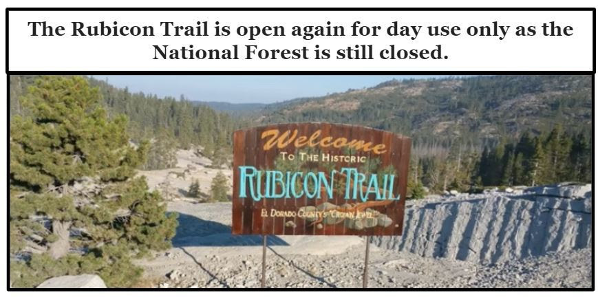
The Lake Tahoe Basin Management Unit closure order 19-21-05 remains in effect for the following backcountry areas: Desolation Wilderness, Meiss Country, Barker Pass and McKinney/Rubicon through September 19, 2021.
Repopulation consists of complex coordination between fire, law enforcement, public works, and utilities to ensure the safety of residents and fire responders alike.
The public is reminded to stay vigilant on current fire conditions. Please continue to adhere to road closures and any evacuation orders and warnings. A reminder to drive slowly and yield to emergency personnel in the area. There will be smoke in the respective areas as firefighters continue firefighting operations. If at any time you feel unsafe, please call 911. For tips on returning home after wildfire visit: Returning Home Checklist - Ready for Wildfire.
For more specific information and resources from your local utility company visit the links below:
- PG&E https://tinyurl.com/PGECaldor
- Sacramento Municipal Utility District https://tinyurl.com/SMUDCaldor
- El Dorado Irrigation District https://tinyurl.com/EIDCaldor
- Grizzly Flats CSD: https://tinyurl.com/GrizzlyCaldor
- Liberty Utilities: https://tinyurl.com/LibertyCaldor
- ATT: https://tinyurl.com/ATTCaldor
- Comcast: https://tinyurl.com/ComcastCaldor
Please go to: www.tinyurl.com/EDSOEVAC for an online evacuation map.
All previous evacuation orders and warnings remain in effect.
For additional information regarding the Caldor Fire, visit https://linktr.ee/imt6
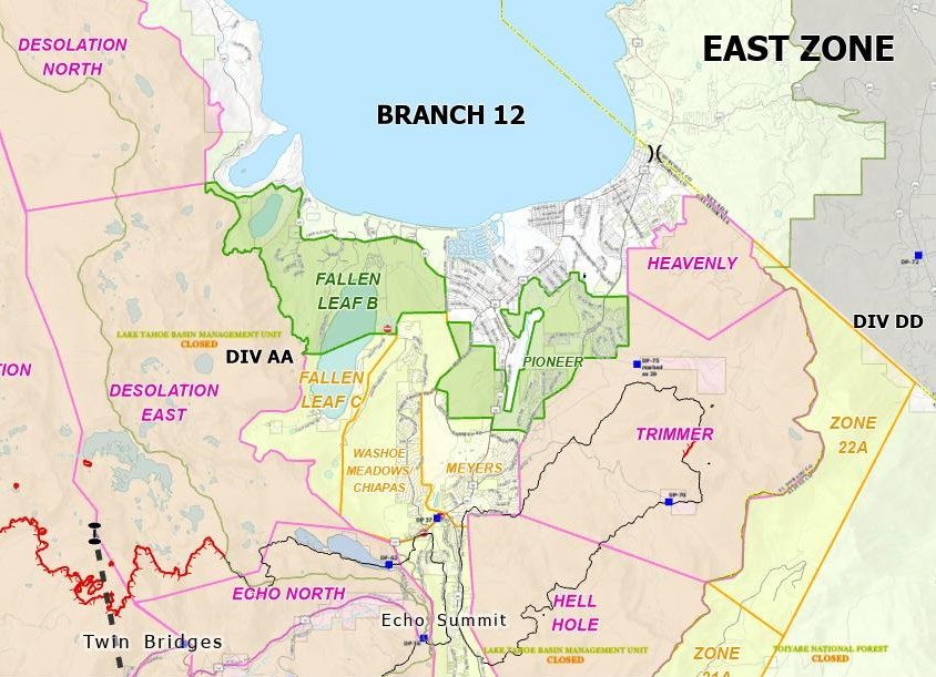 Red area indicates evacuation orders.
Yellow area indicates evacuation orders downgraded to warning.
Green area indicates evacuation orders lifted.
Caldor Fire Recovery
 El Dorado County is committed to helping all residents impacted by the Caldor Fire. As part of this commitment, the county is providing Caldor Fire Recovery resources to help local residents. Important information regarding debris removal, tree removal, returning home, right of entry, utilities, health and safety, is available in addition to rebuilding, property tax relief, property tax payments, insurance, animal care, housing and shelter. El Dorado County has created a Local Assistance Center (LAC) to help residents with county administrative assistance. Read the latest Caldor Fire Information and review Frequently Asked Questions. Please follow all lawful orders and use caution when approaching fire impacted areas.
Read more about Caldor Fire Recovery
Eldorado National Forest Emergency Closure Continues through September 30th as USDA Forest Service Reopens Other Forests in California
The USDA Forest Service Pacific Southwest Region will end the regional closure order affecting most National Forests in California at 11:59 pm -- Wednesday, Sept. 15 -- two days prior to the original end date of Sept. 17. This change does not apply to the emergency closure order for the Eldorado National Forest which remains in effect through September 30, 2021.
Forest-wide closures will also remain in place and will be extended until midnight on September 22nd on the Los Padres, Angeles, San Bernardino, and Cleveland National Forests in Southern California due to local weather and fire factors, as well as a temporary strain on firefighting resources supporting large fires in other areas of the state.
In addition to the four National Forests that will remain closed in Southern California, some National Forest System lands throughout the state will be closed under local closure orders in areas of ongoing wildfires to ensure public safety. The Eldorado National Forest emergency closure is due to ongoing hazards associated with the Caldor Fire. Fire restrictions also remain in place across all National Forests in California to prevent new fire starts. Please refer to the local National Forest that you plan to visit to obtain specific information on closures and restrictions.
“We are constantly evaluating weather and fire conditions in California, as well as regional and national firefighting resources available to us so that we can ensure the safety of the public and our firefighters,” said Regional Forester Jennifer Eberlien. “Some factors are more favorable now, which is why I decided to end the regional closure order. I want to thank the public and our partners for their patience and understanding during these challenging times.”
Factors leading to this decision include:
- Anticipated increase of firefighting resource availability to California due to fire danger lessening in other areas of the country.
- Regional weather systems and related climate zones becoming more variable as the seasons change, leading to less uniform conditions across California. Where weather and fire danger remain high, tailored fire restrictions and closures remain in place locally and may be added where necessary.
- Peak summer visitation has tapered off significantly since the Labor Day holiday weekend. The public is a critical partner in mitigating risk and recreating responsibly on our National Forests.
- We recognize the important role of National Forests to peoples’ livelihood and quality of life.
Favorable fire conditions remain throughout many parts of the state, and the public’s role in recreating responsibly has never been more important. We remind visitors to practice self-sufficiency during visits to National Forests, be aware of fire conditions in the area you are visiting and follow guidelines to prevent human-caused fire starts. Best practices include:
- Heed local information regarding trails and campgrounds, especially fire restrictions and closures. Generally, camp stoves with a shutoff valve will be allowed.
- Be proactive in your thinking about preventing fire starts. Smoking, parking in grass, flammable material, and other activities could cause fire ignition under dry conditions.
- COVID-19 remains a concern. Maintain at least six feet distance from others.
- Do not gather in groups and please follow the latest guidance from officials.
- Communicate with others as you pass. Alert trail users of your presence and step aside to let others pass.
- Pack out your trash and leave with everything you bring in and use.
- All services may not be available, so please plan accordingly.
More than 7,404 wildfires have burned over 2.25 million acres across all jurisdictions in California. The nation remains at Preparedness Level 5 (PL5); the Northern California Geographic Area is at PL5, and the Southern California Geographic Area has moved up to PL4.
The Humboldt-Toiyabe National Forest is largely in California but is in the Intermountain Region (R4) and is not impacted by the previous closure order.
The Forest Service thanks our partners and the public for their cooperation and understanding. Citizens with specific questions within their area should consult their local forest website or social media pages for more information.
|


