|
The Sunshine Mile Overlay
On Tuesday, Mayor and Council received an update on the development of the Sunshine Mile Overlay. The Overlay will come back to Mayor and Council later this summer to consider adoption.
The Overlay was developed to help the Broadway corridor maintain it’s small, local businesses and attract a mix of uses and users desired by adjacent neighborhoods. The details of the Overlay are a little wonky and, probably for that reason, there’s some confusing information out there about what it does and does not do.
The Ward 3 team want to do our best to break it down. We put together these FAQs in an effort to do so. We invite you to read the responses to the answers you are a little shaky on and skip those that you already know well.
1.What is an Overlay?
An overlay is a zoning tool that can direct development towards alignment with the vision of the overlay district. Overlays are used throughout the U.S. and can either incentivize or regulate certain types of development through zoning.
2.Why do we need an Overlay along Broadway?
Because of the road widening, a number of smaller businesses along Broadway will lose portions of their lots, affecting access to parking. Still other structures will be demolished completely and will leave remnant lots behind that would be challenging to redevelop using the existing zoning. In each case, more flexible zoning than what is available currently will allow creative solutions to address parking needs and stimulate multi-modal travel. In so doing, the Overlay will help to reactivate the street and allow small businesses to thrive.
As part of the Overlay process, adjacent residents identified a number of goals that are woven into the proposed Overlay. In sum, the Overlay aims to incentivize affordable housing, protect historic architecture, encourage creative infill, develop a robust multi-modal corridor, and ensure ongoing neighborhood participation in future Overlay developments.
3. Why is this Overlay focused on incentivizing rather than requiring certain types of development?
The Sunshine Mile Overlay creates a voluntary zoning tool to encourage the land use practices that neighbors desire. State law prohibits actions by cities to require certain land uses. As a consequence, the Overlay needs to be attractive to would-be developers.
In 2006, the Arizona Legislature passed Proposition 207 requiring local governments to compensate a private property owner if the value of a person's property is reduced by the enactment of a land use law, including downzoning.
In 2015, the Arizona Legislature passed a law, signed by Governor Ducey, that prohibits municipalities from requiring affordable housing be incorporated into residential developments.
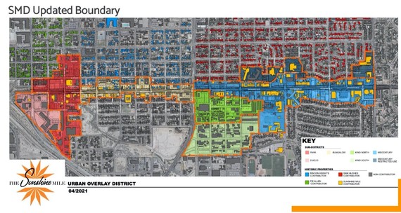
4. Where exactly will the Overlay be?
 5. What will the Overlay Do?
The Overlay was drafted to encourage meeting the goals mentioned under #2 above. Whether the Overlay is effective at delivering on these goals, will depend on developers opting in to use the Overlay as opposed to the existing underlying zoning. That means, they will likely need to find some flexibility to remain either cost neutral or experiences some cost savings.
Affordable Housing - Specifically, developments may utilize a density bonus (not height) and parking reduction when including at least 15% affordable units at 80% AMI (or the equivalent of a two-person household earning $40,000 annually). This gets a little complicate, but the main take-away is that the Overlay gives benefits in density to achieve greater affordability.
Specifically, the density bonus is either a 25% increase for rental units or 15% increase for ownership.
Rental projects can achieve a 35% density bonus if the project provides the 25% affordable units and is located within 650 feet of a mobility hub or transit stop. In addition, there is a 62% parking reduction incentive for the affordable units in a project.
Any project that provides 10 or more residential units is eligible to participate.
The affordable units must be integrated into the market-rate units. Rental units must remain affordable for 50 years and ownership units must remain affordable for 30 years.
Mobility – Like affordable housing, the inclusion of a “mobility hub” can allow projects to utilize a density bonus and in some subdistricts that can be a height bonus. These micro-mobility hubs will cater to bus stops, trolley stops, bike share stations, bike repair and parking, car share and other options.
Walkability and Public Space – The Overlay requires ample sidewalks, shade covering a minimum of 50% of pedestrian areas, and encourages the activation of alleyways in order to provide additional pedestrian circulation. Projects are required to provide open space such as public plazas in order to create gathering places. These spaces must include seating, shade and other elements. All landscaping must consist of desert-adapted plants.
Historic Preservation - Projects are not eligible for the Overlay if they demolish historic structures or would cause a historic structure to be delisted. The Tucson-Pima County Historical Commission’s Plans Review Subcommittee (PRS) will review all projects that are proposing alterations or additions to an existing eligible or contributing historic structure using the Overlay.
What types of developments are intended in each subdistrict?
Euclid/Park Subdistrict - This Subdistrict has two subareas.
The Park Subarea includes a number of properties with higher-intensity underlying zoning (i.e. R-3, C-1 and C-2). The Park Subarea is intended to be a transition between the neighborhood and the Euclid Subdistrict and includes the Lost Barrio. The Park Subarea is primarily envisioned to be a residential area where higher-density housing options are encouraged to support retail and services along the Sunshine Mile.
The Euclid Subarea – This subarea is predominantly industrial-zoned. Euclid Subarea provides opportunities for Mixed-Use Development featuring light industrial and/or commercial spaces with residential components that are not currently permitted within the underlying industrial zoning. Light industrial uses, especially in the form of artisan, craftwork and “makerspaces,” are encouraged. High-density residential uses are also appropriate and will provide the population necessary to support commercial development along the Sunshine Mile and Park Avenue.
Bungalow Subdistrict - Characterized by its small, historic buildings that should be celebrated through their preservation and Adaptive Reuse into local businesses and neighborhood uses, this subdistrict has already seen focused neighborhood engagement on re-envisioning the use of historic properties that were moved by Rio Nuevo and will now be adaptively reused.
Kino Subdistrict – This Subdistrict has two subareas.
The Kino North Subarea encourages infill on vacant lots and adaption of current uses. This Subarea is a intended to support Transit-Oriented Development, including mobility hubs and high-density residential and commercial development. Light industrial uses, such as artisan, craftwork and “makerspaces,” are encouraged along with high-density residential uses to provide the concentration of people to support the commercial uses along the Sunshine Mile.
The Kino South Subarea, located in the Arroyo Chico Neighborhood, includes many existing industrial properties that present creative Adaptive Reuse opportunities. While promoting the industrial uses permitted in the underlying zoning, complementary uses, including retail, bars and restaurants, will be allowed to create a more dynamic mix of street-level activity. This mix of uses will also complement the higher residential density in the Kino North Subarea.
Mid-century Subdistrict – The primary objective in this district is to preserve the historic character and structures. Adaptive Reuse of its unique mid-century buildings—which often feature narrow storefronts with smaller footprints that lend themselves to local businesses and incubator spaces—is strongly encouraged.
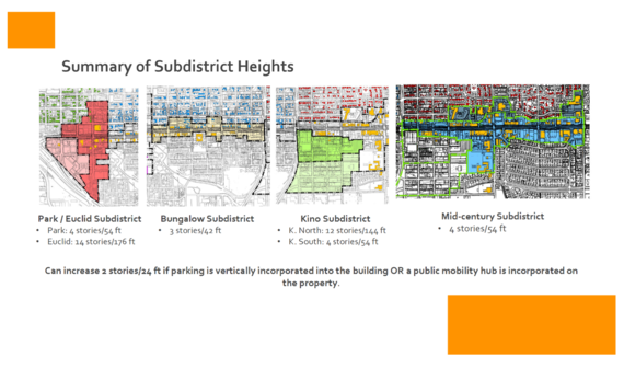
What heights will be permitted and where?
Great question. Check out this handy graphic.
 Still have questions? You can take a look at the full materials reviewed by Mayor and Council earlier this week here.
|