|
Having trouble viewing this email? https://content.govdelivery.com/accounts/AZDOT/bulletins/17a540a
|
|
 
Rain and wind gusts should turn overnight to light
snow in high country
|
|
|
|
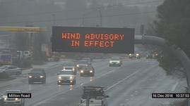 PHOENIX – A winter storm packing rain, wind and, later, the
possibility of light snow and ice in the high country is all the more reason
for Arizonans to drive with care and adjust their speed to conditions.
While much of the state is expected to see rain Friday, the
forecast for many areas also calls for sustained winds of between 30 and 40 mph
and even stronger gusts. Beginning Friday night, a cold front will lower snow
levels to around 5,000 feet and drop temperatures, meaning drivers in Arizona’s
high country should be prepared for the possibility of light snow accumulating
as well as ice on the road.
The Arizona Department of Transportation’s nearly 200 snowplows
and 400 certified snowplow drivers are ready to deal with snow and ice, and
ADOT’s website offers tips for driving in the rain, in
wind that reduces visibility and around
snow and ice.
Here are some of them:
- Slow
down and be aware of the risk of skidding or hydroplaning.
- Maintain
a safe distance between your vehicle and the one in front of you. This
helps prevent sudden braking, which can cause you to slide on wet or icy
pavement.
- Before
you drive, inspect your windshield wipers, and replace them if necessary.
- Turn on
your headlights while driving in bad weather.
-
If
you’re planning to drive in the high country, consult ADOT’s Know Snow
winter-driving tips at azdot.gov/KnowSnow. These
start with wearing warm clothing, having a fully charged cellphone and
making sure your tank is at least half full at all times.
For the most current information about highway conditions and restrictions
statewide, visit ADOT’s Travel Information Site at az511.gov, follow us on Twitter (@ArizonaDOT) or call 511.
|
|
|
|
|