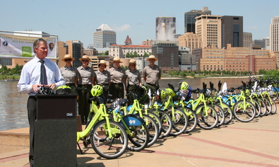
St. Paul Mayor Christopher Coleman speaks at the launch event for Nice Ride Minnesota along the Mississippi River. Image courtesy of the National Park Service.
Partnership improves access to Minneapolis-St. Paul urban riverfront
The Mississippi National River and Recreation Area (MNRRA) covers a 72-mile and 54,000-acre corridor through the Minneapolis - St. Paul metropolitan area and includes natural, historical, recreational, cultural, scenic, scientific, and economic resources of national significance. Unlike traditional units managed by the National Park Service (NPS), the MNRRA is not a major land owner and therefore does not have control over all of the park’s land use. Instead, the MNRRA works with dozens of partners: local, state, and federal governments, non-profit organizations, businesses, educational institutions, and individuals.
In 2010, the MNRRA developed an Alternative Transportation Plan (ATP) to improve transportation access for the region’s urban and suburban residents, and for out-of-town visitors. The MNRRA began working with the Public Lands Team in 2011 to define and create a seamless Alternative Transportation System (ATS) that serves its visitors and achieves goals of the MNRRA’s ATP, as well as goals of the NPS Director’s Call to Action and America’s Great Outdoors (AGO).
A challenge for the MNRRA is that no single transportation system serves visitors or connects area residents to the river and its major destinations. The absence of a seamless and recognizable transportation system creates visitor confusion, neighborhood disconnection, and challenges with the park’s identity and safe navigation. The MNRRA determined that one way to address this challenge was through the installation of a bike share system along the river to serve as the link between existing transportation facilities, river access, and surrounding urban neighborhoods.
With assistance from the Volpe Center, MNRRA partnered with Nice Ride Minnesota in June 2012 to install 30 new bike share stations to supplement already existing stations along the river in Minneapolis and St. Paul. These stations have increased non-motorized access to the river, built identity for the park (every station includes the NPS arrowhead and information on the innovative Ranger on Call Program), and improved accessibility and local economies in station areas.
In September 2012, the MNRRA applied to the Paul S. Sarbanes Transit in Parks Program to install 17 additional Nice Ride bike share stations along the Mississippi River in Northern Minneapolis. These stations will provide connections to underserved communities along seven miles of the river. This project is a partnership effort between NPS, Nice Ride Minnesota, Blue Cross Blue Shield Minnesota (who funds the bikes for the stations), the City of Minneapolis, the Minneapolis Park and Recreation Board, and the Minneapolis Riverfront Corporation.
Reports on alternative transportation in the National Park Service published
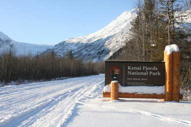
Kenai Fjords National Park
In February 2012, the Public Lands Team completed a report on the feasibility of over-the-snow transportation services at Kenai Fjords National Park. Year-round access would better enable the park to accomplish its mission objectives related to visitor experience, education, and research. Herman Leirer Road within the park, however, is inaccessible to cars November through April because of snow and ice conditions.
An over-the -snow service would carry passengers in a vehicle with treads instead of wheels up the snow-covered road. Through a site visit, interviews, and independent analysis, the study team examined existing conditions, comparable services, vehicle options, market demand, owner-operator models, and business models. The final report presents an analysis of indirect costs to the park, business model options that seek to limit NPS liability, ideas for partnerships with the local business community, and recommendations regarding vehicles, schedules, and potential markets.
You can view the Kenai Fjords National Park Over-the-Snow Transportation Feasibility Study here.
Project contact: Lindsey Morse
Fire Island National Seashore
Additionally, the Public Lands Team recently published a report on alternative transportation at Fire Island National Seashore. The transportation challenge addressed by the Public Lands Team's report is to balance the many kinds of vehicle use on the island with the seashore's resource protection mission and the desire of residents and visitors to preserve the island's "roadless" nature.
The existing conditions section characterizes the diverse transportation systems currently in use on Fire Island, many of which have evolved to function in line with the island's roadless character. The opportunities section focuses on vehicle use reduction and enhanced use of water transportation, as well as ideas aimed at general improvement of the efficiency and function of the whole transportation system on and around Fire Island.
You can view the Fire Island National Seashore alternative transportation study here.
Project contact: Frances Fisher
Updates to our website
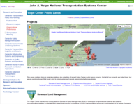
Our website is regularly updated with new features and information about Public Lands Team projects. We invite you to explore our new interactive map to see some of the places where we have done work!
|
Volpe attends Transportation Scholars orientation
Alex Linthicum of the Transportation Planning Division participated in the joint orientation session of the 2012 National Park Transportation Scholars and 2012 Public Lands Transportation Scholars in Lakewood, Colorado, from June 3-6. During the meeting, Mr. Linthicum presented an overview of the Volpe Center and the technical resources it may provide the scholars during their tenure. Mr. Linthicum also assisted the NPS Transportation Branch with providing an overview of the Alternative Transportation Program. The trip included a site visit to Arapaho National Forest where Mr. Linthicum provided the scholars with an introduction to an upcoming Volpe work effort at the forest.
Federal alternative transportation grants coordinated on Cape Cod
On March 13, Anna Biton and Frances Fisher of the Transportation Planning Division participated in meetings regarding the coordination of recent awards to Cape Cod National Seashore and Monomoy National Wildlife Refuge, granted through the Paul S. Sarbanes Transit in Parks (TRIP) program.
Ms. Fisher participated in the morning meeting, discussing coordination and next steps for multiple recent and current TRIP projects. The Volpe Center worked on many of these projects and was involved in scoping some of the new ones. Ms. Biton participated in the afternoon working session focusing specifically on the award to implement a transit shuttle service at the Monomoy National Wildlife Refuge. The Volpe Center completed an Alternative Transportation Planning Study for Monomoy in 2012 that informed the application for this grant. 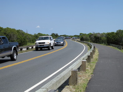
Work continues on the business plan for alternative transportation at Assateague Island
This Public Lands Team report will analyze and evaluate potential expansion of the existing alternative transportation system in and around Assateague Island National Seashore. When published, it will present a business plan for implementation of transit and nonmotorized transportation services. This work is being carried out in conjunction with other previously completed transportation studies.
Volpe Center enters Phase II of the study for Mount Baker-Snoqualmie National Forest
Phase I of the Mount Baker-Snoqualmie National Forest (MBSNF) Alternative Transportation Feasibility Study was recently presented to the U.S. Forest Service. The report is intended to assess transportation issues, and evaluate solutions for those issues, on and along the four major highway corridors through the MBSNF. The Forest Service has selected the Public Lands Team to conduct Phase II, with assistance from Western Federal Lands Highway Division and West Virginia University. Phase II of the study is expected to be completed in 2013. The study received a planning grant from the Paul S. Sarbanes Transit in Parks Program and resulted from a 2007 Interagency Transportation Assistance Group visit and report, in which the Public Lands Team participated. 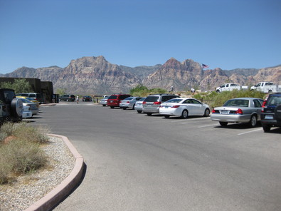
Study for the Bureau of Land Management recently completed
Red Rock Canyon National Conservation Area is a popular Bureau of Land Management (BLM) natural area located near Las Vegas, Nevada. Red Rock Canyon experiences heavy congestion on its Scenic Drive and associated parking areas, due to high volumes of visitors hiking, climbing, and sightseeing along the Drive. The Volpe Center completed a Transportation Feasibility Study examining four transportation alternatives that combine parking expansion, transit service, and management strategies to address parking congestion.
The BLM chose to advance one alternative into an Environmental Assessment (forthcoming) to move towards implementation. The selected alternative adds seasonal transit service to Red Rock Canyon, including opening the one-way loop to two-way transit serving several of the most popular parking lots. It also includes limited parking expansion and a shuttle dedicated to hikers and climbers.
|