 A Message from the Director
What does the future
hold for Baltimore? What is our collective vision, and what do we need
to do to get from where we are today, to the brighter future we all hope
for? These are the things we think about every day in the Department of Planning.
Planners want to make
the world a better place, and the people of the Department of Planning have one
central mission: to make Baltimore the most livable, dynamic, sustainable and
attractive city it can be, now and in the future.
To help the City of
Baltimore achieve its full potential, the Department of Planning focuses on
empowering communities, guiding development, promoting quality urban design,
recognizing and adapting to change, preserving and promoting our historic
heritage, all while seeking to make Baltimore greener, and more
sustainable.
To accomplish these
goals, we work hand-in-hand with the Mayor, the City Council, our fellow City
agencies, community organizations, the business community, foundations, state
and federal partners, and the citizens of Baltimore themselves. This
annual report features a range of activities and projects we worked on in 2011,
some of which have continued into 2012.
Progress is being
made, despite our local and national economic struggles. I hope this
report gives you some useful information about the direction we’re
heading. I also hope it inspires you to get more involved in helping to
make our collective vision a reality.
Best regards,
Thomas J. Stosur,
Director of Planning
|

In preparation for the
National Bicentennial Celebration of the “The Star-Spangled Banner”,
the Department of Planning and the Commission for Historical and Architectural
Preservation CHAP Restored
Baltimore’s Battle Monument.
After almost 200 years
of exposure to the elements, the “Lady Baltimore” sculpture on top of the
monument is extremely fragile and must be relocated to a stable interior
environment. The original “Lady Baltimore” will be moved to the Walters Art
Museum and a reproduction will be installed, replacing the fragile original.
The four “Griffon” sculptures will be reconstructed on site, so that the
crucial missing features will be restored.
On September 12 and
13, 1814, Baltimore achieved an incredible victory over the forces of the
British. The Battle Monument, begun in September 12, 1815, and completed in
1825, is the first significant war memorial to be built in the United States.
It commemorates the sacrifices of those who died in defending the city from the
British attack in September of 1814, the same attack which was the occasion for
the writing of the National Anthem. It is also the first monument in the United
States to honor the common soldier. As the emblem of Baltimore City, the
restored Battle Monument will be a source of civic pride during the National
celebration! Read More about the Battle Monument.
From Planning to
Implementation: Progress in Park Heights
Several years ago the
Planning Department worked with community stakeholders to develop the Park
Heights Master Plan. The Master Plan has resulted in millions of dollars
of investment by a wide range of partners.
Recreation and Parks
is putting the finishing touches on renovations of a multi-purpose field at
Reisterstown Road and Woodland Avenue. As part of this project three
buildings were demolished, including the infamous Night Owl Lounge. The
practice field was renovated and re-graded for games, old play equipment was removed
(new equipment was installed a few years ago across the street), new fitness
equipment and game tables were installed, and the basketball court was
converted to parking.
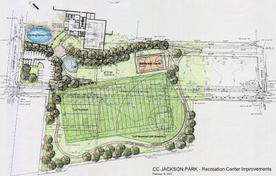
Baltimore Housing is
completing site assembly along the 4900 block of Denmore Avenue for the future
development of a new 7-acre park. The Cal Ripken, Sr. Foundation has partnered
with the Department of Recreation and Parks to develop the first phase of this
park.
The design process is still at the early stages; but so far
the design includes a multi-purpose field (baseball/football), basketball
court, playground, splash pad, walking path, and parking lot. In
addition, design is beginning for renovation and expansion of the adjacent CC
Jackson Recreation Center.
Park Heights
Renaissance, Inc. (PHR) and Comprehensive Housing Assistance, Inc. (CHAI) have
partnered to secure HUD 202 funding to build 60 units of senior housing at the
former site of “The Ranch” at Pall Mall Road and Pimlico Road.
Groundbreaking is expected by the end of the year.
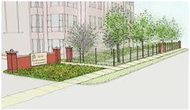
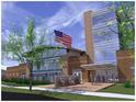
Photo Note: The image above is a
perspective site drawing of the future Renaissance Gardens, a 60-unit
senior living community being developed as a result of the Park Heights Master
Plan. It also inspired the title of our annual report and appears in the
header above.
The
GRACE Master Plan
The Greater Rosemont and Coppin Heights
Community (GRACE) Area Master Plan
kicked off in 2011. Centered around the Coppin State University campus
and a major portion of west Baltimore, the plan will focus on stabilizing
residential areas, improving transportation and green spaces and creating
connections between anchor institutions, like Coppin and Baltimore City
Community College (BCCC), and with the surrounding communities.
|
Mount Vernon Master Plan
Planning for the
historic Mount Vernon area is
now underway. With a diverse range of residents including students,
seniors, families and empty-nesters, Mount Vernon is a vibrant, centrally
located mixed-use neighborhood, that also serves as a cultural hub for the
city. This broad based community planning effort brings together
residents, businesses and institutions to address long term goals and short
term development issues. Transportation, parking and open space are key
issues to be addressed.
Seton Hill Master Plan
The Seton Hill Master Plan
was completed in 2011, and recently adopted by the Planning Commission.
The Seton Hill Master Plan makes recommendations for land use, zoning, open
space and transportation in this small historic community, on the northwest
corner of downtown. Priorities include open space improvements and
programming, preservation of historic homes, and the clarification of traffic
patterns within the neighborhood to support this residential neighborhood just
north of Downtown’s Westside.
|
Belair Road TAP Study
The study of Belair
Road began in 2007/2008 as a community driven effort between the City &
County to develop a corridor study for revitalization. In spite of these
efforts, the impetus behind the Belair Road TAP came when the Planning
Department was awarded a 2010 EDA grant to complete a study with the help of an
Urban Land Institute Technical Assistance Panel.
 The study consisted
of a two-day workshop, input from expert panelists, and a final report
completed in November. This report will serve as a catalyst to help bring new
development opportunities to Belair Road.
|
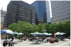
Downtown Open Space and Strategic Plan
Based on the 2010 Census, downtown Baltimore‘s
Census Tract 401 was the City’s fastest growing neighborhood, with a population
increase of approximately
131%, mostly within the 18-34 age groups. In 2011, the Department of
Planning teamed up with the Downtown Partnership on the creation of a Downtown Open Space Plan
and a Downtown Strategic Plan
in an effort to keep this trend going. In fact, the Department received
an award from the Downtown Partnership for its work in support of our thriving
downtown.
Celebrating President Street Station, A Civil
War Landmark
In 2011 the Mayor, in
partnership with CHAP, the Baltimore National Heritage
Area and the Friends of President Street Station, rededicated this
significant national treasure. Timed to coincide with the 150th anniversary of
the Civil War, the exhibits were updated and the structure was rehabilitated.
In April of 2011, the Eastern National Bookstore
opened a popular museum store in the museum.
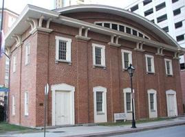
In addition, due to
its deep history and links to Abraham Lincoln, Frederick Douglass, the
Underground Railroad, and the first bloodshed of the Civil War, our U.S.
Senators Barbara A. Mikulski and Ben Cardin (both D-MD) introduced legislation that
authorizes the U.S. Department of Interior to evaluate the suitability and
feasibility of establishing President Street Station as a unit of the National
Park Service (NPS).
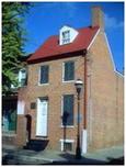
Ashburton becomes Baltimore’s 32nd Historic
District
Ashburton captures the essence of architectural
styles and suburban house types of the 1920s. English Tudor, Colonial
Revival, Italian Renaissance Revival, French Revival and other stylistic
details decorate these houses. This well-cared for early 20th century
suburban neighborhood has been the home of many prominent Baltimore African
American leaders. Ashburton’s significant design and strong community
association helped shape 20th century suburban development in Baltimore.
As a designated local historic district, all future exterior improvements and
new development will be reviewed by CHAP for compatibility with Ashburton’s
historic character. Qualified renovation projects will be eligible for
Baltimore City Historic Tax Credits.
Baltimore by the Numbers: 2010
Census Data Analysis
The results of the
U.S. Census are important to Baltimore because they are used to designate
political boundaries, help understand community needs, and direct the
allocation of state and federal funds. Many neighborhood organizations,
foundations and universities analyze this data to help identify where and how
to invest limited resources.
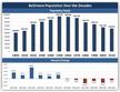
To better understand the Census and its
results, the Department of Planning is engaging in a thorough analysis of
Census and other data sources to assess changes in Baltimore and its
neighborhoods.
These analyses will be disseminated to the
general public through a series of policy briefs, called “Baltimore by the
Numbers”. These reports can then be used by citizens, nonprofit
organizations and civic leaders to inform and guide our efforts to make Baltimore
a better, safer and stronger place to live and work.
|
Upon completion of the Healthy Food Assessment
in summer 2011, the BFPI (Baltimore Food Policy Initiative), housed within the
Department of Planning, launched the Get Fresh Public Markets
to improve the availability of healthy prepared foods in Baltimore City’s 6
public markets. As a result, BFPI developed 14 menus with healthy food labels,
conducted 2 consumer focus groups, and surveyed 75 residents for a community
food assessment as it relates to Lexington Market.

In partnership with Johns Hopkins Center for a Livable Future
(CLF), BFPI recently created a Baltimore City food desert map.
In Baltimore City, 20% of the population lives in what is considered a “food
desert,” and nearly 1 in 4 of Baltimore’s school aged children live in a food
desert.
BFPI is developing a citywide food desert retail strategy to support
community-based partnerships to attract, retain, and enhance healthy food
retail in Baltimore City.
|

BFPI and Maryland Hunger Solutions collaborated
to increase the number of Baltimore City farmers markets accepting SNAP
(formerly known as food stamps) from 3 to 7 markets. The SNAP sales at
Baltimore City farmers markets increased 45% from 2010 to 2011, with 4
additional farmers markets now accepting SNAP. In coordination with Baltimore
Office of Promotion and the Arts, Baltimore City’s largest farmers market, the
Baltimore Farmers’ Market & Bazaar, will begin accepting SNAP benefits in
2012.
|
This fruit and vegetable campaign created by
kids for kids included 2,000 elementary students creating 250 ads displayed in
16 interior bus panels, 10 metro station posters, 5 light rail station posters,
and 7 Metro kiosks. The students’ ads are now a part of the citywide healthy
eating campaign. In addition, the campaign developed 5 public service announcements.
The Edgar Allan Poe House
While the national and
international media continue to cover the Poe House and its events, a consultant team
was hired by the City to develop a business strategy to keep the Poe House
open, without depending on annual City funding.
The Edgar Allan Poe Birthday Celebration in
January continues to be a success story, as are the fundraising events designed
to raise funds for the Poe House, including: the Annual Cask of Amontillado
Wine Tasting Event; Forevermore Gaia Print Sales; Pennies for Poe, sponsored by
writer Rafael Alvarez; Poe Night at the University of Baltimore; the Lebanese
Taverna Halloween Fundraiser; and the Bedlam Ensemble production of "The
Delirium of Edgar Allan Poe" in New York City.
In 2011, the Poe House
was chosen to help promote the new John Cusack film "The Raven", through a Hollywood-style
news conference at the Poe Grave, featuring the director and one of the stars
of the film. As a result of this collaboration, the movie company
sponsored a private Baltimore screening of the movie 2 days prior to the
national release. The event was attended by 240 friends of the Poe House,
at the Landmark Theater in Harbor East.
Overall, it was a great year for the Poe House –
as more and more people are visiting by walking from downtown destinations and
using the Charm City Circulator.
|
 “Raven” print generously donated by the artist
“Gaia” to sell for the benefit of the National Historic landmark Edgar Allan
Poe House and Museum.
|
Our Mission...
To
provide the highest level of service and leadership in urban and
strategic planning, historical and architectural preservation, zoning,
design, development, and capital budgeting, to promote the sustained
economic, social, and community development of the City of Baltimore.
TransForm
Baltimore: the Zoning Code Rewrite
As called for in the Comprehensive Master Plan,
the City of Baltimore Department of Planning kicked off TransForm Baltimore:
The Zoning Code Rewrite in 2008. The goal of this ambitious multi-year
effort is to review, rewrite and replace the existing code (circa 1971) with
modern tools that will support and guide City investment, enhance and protect
neighborhood character, strengthen retail districts, and promote job growth.
Throughout the entire
process, TransForm Baltimore has involved an extensive community outreach
campaign that has gathered input from citizens, businesses, the development
community, professional organizations and others committed to the future of the
City of Baltimore. Through the use of community forums, community
planning, surveys, working committees and focus groups, the Department has gathered
input from a wide array of interested stakeholders, and will continue to do so
throughout 2012 as the new code is introduced, and ultimately adopted and
implemented.
We are planning to introduce City Council
legislation during 2012, and that will mark the first step in the legislative,
adoption and implementation phase of this important and long overdue
initiative. For more information, please go to www.rewritebaltimore.org.
Historic District Permit Activity Breaks All
Records
Despite the current
economic climate, 638 CHAP Notice to Proceed permits were issued in locally
designated historic districts city-wide during 2011. This number is a strong
indicator of the desirability of Baltimore’s local historic districts and
continuing investment in historic properties, as well as dynamic and
historically-compatible new construction projects.
Union Wharf: New construction currently underway in the Fells Point Historic District
Historic Tax Credits Boost the Local Economy
Since the program’s
inception in 1996, the Historic Restorations and
Rehabilitations Tax Credit program has generated over $500 million
in investment in the City’s historic properties. A new and exciting trend over
the past year has been the use of historic tax credits in rehabbing entire
blocks or groupings of homes to stabilize neighborhoods in transition.
Groups like Habitat
for Humanity of the Chesapeake, Telesis Baltimore, The Reinvestment Fund (TRF),
Druid Heights CDC, and Yankee Development, LLC, have been rehabbing groups of
properties in historic districts including Patterson Park/Highlandtown, East
Monument, Broadway East/South Clifton Park, Old East Baltimore, Old Goucher,
Reservoir Hill, and North Central.
Through their
organizations’ unique approaches, they have worked to bring homeowners to
formerly vacant blocks. Some have taken advantage of City programs like Vacants
to Value, but all have followed CHAP guidelines and have qualified the
properties for the historic tax credit. In 2011, CHAP approved over 70 tax
credit applications from these groups and certified the completion of 36 of
those projects.
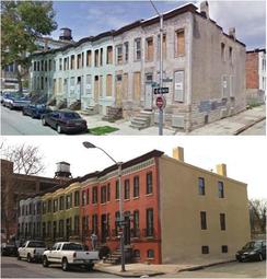
Before & After: Historic Rehabs in Oliver
Maryland Proton
Treatment Center (MPTC)
The Maryland Proton Treatment
Center (MPTC), part of the University of Maryland BioPark Planned
Unit Development (PUD) will provide cutting edge proton therapy for patients
with cancerous tumors. MPTC will treat approximately 2,000 patients
annually with the potential to improve medical outcomes, reduce side effects
and promote the understanding of the use of advanced technologies in cancer
therapy.
 The project totals approximately 108,500 square
feet of space within this three story building. It has been carefully
designed to meet its special healthcare needs while fitting in to the overall
character of the BioPark.
|
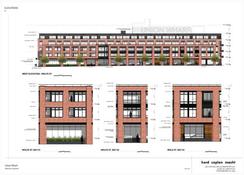
Under Armour (Formerly Tide Point) PUD
Located in Locust
Point, a neighborhood rich in character and history, is the former Procter
& Gamble soap factory, circa 1929. In 2009, this former industrial
complex was transformed into the Tide Point Planned Unit Development (PUD), a
25-acre site with approval for over 549,590 square feet of office, retail and
up to 140 dwelling units. Tide Point includes open space leading to and along
the water, as part of Baltimore’s public promenade.

Under Armour purchased the Tide Point Campus
and by electing to remain on-site, created a revised master plan to meet the
company’s projected space needs for the next ten years. There are currently
1,100 employees at Under Armour, and they are growing at a current rate of 300
additional employees per year. Under Armour will expand into the water side
portion of the PUD, adding levels above the existing buildings as well as
replacing the Tide building with a new, larger facility and parking
garage.
Under the revised PUD, the allowable retail
square footage will increase from 25,500 to 50,000 sq ft, and the allowable
office square footage will increase from 528,078 to 925,000 square feet.
As a result, Under Armour can grow on-site, providing an important employment
anchor for the City.
|
In Case of Emergency: All Hazard Planning
The City faces many
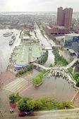
different natural hazards that impact our health and welfare. Flooding, heat
waves, high winds, and snow have the most prominent impact on the City.
 In 2011, the Planning
Department secured a grant to create a robust mitigation plan to lessen the
impacts of natural disasters on life and property. This included the adoption
of Digital Flood Insurance Rate Maps that identify areas that are vulnerable to
flooding. The maps will assist the
City to target mitigation measures that minimize damage, and allow for a quick
recovery.
|
 The All-Hazard Mitigation
Plan, the Climate Action Plan and the new Tidal Floodplain Maps, and their
common elements (i.e. public outreach, identification of mitigation/adaptation
measures) are being looked at together. This will allow the City to take
a comprehensive approach in dealing with natural hazards, before they happen.
|
Capital Improvement Planning
By City Charter, the
Planning Commission must submit a recommended six-year Capital Improvement
Plan (CIP) to the Board of Estimates each year. In 2011, the Planning
Commission recommended capital funding for 157 Projects with an estimated cost
of $402,427,000.
Among the projects
recommended for funding were:
- Waverly
Elem/Middle School - $3.6 million
- Library
Facilities Modernization - $1.0 million
- Recreation
Facility Expansion & Modernization - $1.6 million
- Boston
Street Reconstruction - $3.0 million
- Sewer
System Rehabilitation - $134.0 million
-
Uplands
Redevelopment - $2.2 million
The Baltimore City Council is now considering the capital budget for FY 2013, which starts on July 1, 2012.
 |
|
Architectural Rendering of
Future Waverly Elementary-Middle School |
Housing Market Typology
Baltimore’s housing market typology
was developed to assist the City in its efforts to strategically match
available public resources to neighborhood housing market conditions.
 The typology is a critical
tool for Baltimore Housing’s Vacants to Value
program to address city-wide vacant housing challenges. In 2011, the Planning
Department, with Housing, convened a work group to update the 2008 typology in
collaboration with other city agencies and community stakeholders.
|
Regional Sustainable Communities Grant
The City has partnered
with the Baltimore Metropolitan Council (BMC) as one of the recipients of the 2011 Sustainable Communities Grants, totaling
$3.2 million. The Department of Planning, represented by Director Stosur, with
staff from the Research and Strategic Planning Division, will participate in a
Consortium that will develop and implement the Regional Plan for Sustainable
Development (RPSD).
The Baltimore Region’s planning effort will analyze trends
in population, jobs, work force development, housing and transportation, and
create a plan that enhances equity and opportunity for disadvantaged residents,
while promoting long-term sustainability for all jurisdictions in the Baltimore
Region. Planning will provide staff and technical support to help
incorporate HUD’s livability principles into the framework of the plan.
2011 City Landmarks
Since 1971, Landmark
designated buildings and sites provide treasured links to the past and some of
the finest architecture in Baltimore. CHAP coordinates the designation process,
which seeks to protect these valuable assets. The following Landmarks were
officially designated by the Mayor and City Council in 2011 (Click here to Read More):
- Franklin-Delphey
Hotel
- Grace
Turnbull House
- Grand
Masonic Temple
- Hansa
Haus
- Mayfair
Theater
-
St.
Peter the Apostle Church Complex
- Waverly Town Hall
 The push for the
designation of more Baltimore City Landmarks continues in 2012. This year, CHAP
is working with the Downtown Partnership of Baltimore, Inc. to designate
landmarks from a list of over two dozen historically and architecturally
significant buildings in downtown Baltimore.
|
A Climate Action Plan for Baltimore
The Baltimore City
Department of Planning’s Office of Sustainability with the Department of
General Service’s Energy Office will be developing a Climate Action Plan (CAP)
in 2012. The goal is for it to be adopted this coming November.
Baltimore’s Climate Action Plan (CAP) will set short-term (2020), and long-term
(2030) goals for reducing our green house gas emissions as well as responding
to anticipated changes in our climate.
The CAP will signify a huge step toward Baltimore’s
Sustainability Plan goal of reducing green house gas emissions and addressing
the physical impacts of climate change related to flooding and extreme heat
events through adaptation, and we are excited that this process is underway.
For more information on Baltimore’s climate action plan and related
initiatives, click here.
MD Sustainable Communities Designation
Planning is currently
leading an interagency effort to identify areas for neighborhood revitalization
and redevelopment, to be designated under Maryland’s Sustainable Communities
program.
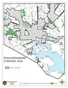
By July 1, 2012, the
city will submit an area-wide framework for sustainability and livability,
through a collaborative, inter-agency effort. The Sustainable Communities
program affords designated areas access to state funding and incentives,
including Historic Tax Credits, Neighborhood Business Works, and enhanced Job
Creation Tax Credits.
Updating Baltimore's Comprehensive Economic
Development Strategy
This fall, Planning
will join the Mayor’s Office of Employment Development (MOED) and BDC to update
Baltimore’s Comprehensive Economic Development Strategy (CEDS).
The CEDS document and
planning process is a prerequisite for consideration of Federal Economic
Development Administration (EDA) funding and can be used as a city-wide
blueprint for future economic development and job creation opportunities.
A significant responsibility of the CEDS team, made up of city, community and
business representatives, will be to articulate the economic challenges and potential
of Baltimore City, and to prioritize city-wide economic development projects
and strategies.
|