|
Follow Us:
|


|
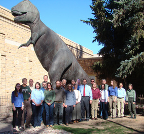
Staff of the Wyoming State Geological Survey, Laramie, Wyo.
Many of the Earth’s minerals are used for industrial purposes, but consumers
may not realize they also benefit from these minerals in a number of their
everyday products. Bentonite and trona are two such resources, with Wyoming being
home to some of the largest deposits in the world and leading the nation in
their production.
Bentonite is an important mineral to the energy industry because of its
use in drilling mud for oil and natural gas wells. Consumers use bentonite when
they buy kitty litter and cosmetics. Read more...
Wyoming’s Medicine Bow
Mountains abound with geologic features and a landscape that serves as the
perfect backdrop for interpretation and road signage. The WSGS plans to
create two new signs along the Snowy Range Byway thanks to grant funding
received from the Wyoming Office of Travel and Tourism.
One of the signs will depict the geology and geologic history behind
the Medicine Bow Mountains, with a billion years difference in the ages of the
rock units across the mountain range. The second sign will illustrate the
effects of glaciation in the Rockies and how the Snowy Range was formed, along
with visuals and text describing the near vertical quartzite rock walls, created
from the sand of an ancient sea. This
signage project, slated for completion in summer 2015, is in collaboration with
the Medicine Bow-Routt National Forest
and Brush Creek-Hayden Ranger District. Read more...
New mineral investigations. WSGS received funding from the Wyoming
Legislature to study several mineral resources, including rare earth elements
(a continuation of a recent study), zeolites, lithium, and iron. These studies
will include final reports provided to the state Legislature in 2016.
Wyoming Oil and Gas
Development Map. The WSGS maintains an interactive map on its website for identifying areas in
Wyoming where oil and natural gas projects are slated for development, and
viewed through Google Earth.
Karst research project. Geologists are studying karst and gypsite occurrences
(including sink holes) in the Laramie Basin, with a report slated for 2015.
Fort Union study. Geologists are researching the Fort Union
Formation for potential mineable coal deposits as well as oil and gas resources.
Powder River Basin
groundwater monitoring study. WSGS continues to compile Bureau of Land Management
data for evaluating the effects of coalbed natural gas production on the
groundwater resources in the Powder River Basin.
StateMap. A
project with funding from the USGS, geologists of the WSGS are conducting fieldwork
for developing and publishing its annual maps on geology in the state – maps
illustrating rocks and deposits found on the surface as well as bedrock geology
for specific regional areas. These maps also support the agency’s larger
projects related to the research divisions of the WSGS. The
next round of StateMap projects under development include preliminary geologic
maps of the Rawlins Peak SW and Shamrock Hills 7.5’ quadrangles (Carbon County)
and a preliminary surficial geology map of the Afton 30’ x 60’ quadrangle
(Lincoln and Sublette counties).
National Coal Resource Data System (NCRDS). WSGS geologists are in the process of gathering stratigraphic data from coal exploration and petroleum wells in Wyoming basins as part of a cooperative national database project among states with coal resources. Coal mining companies are also assisting by providing their stratigraphic data related to active mining operations on state lands.
|
|
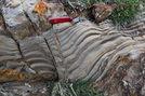
The WSGS has published a
new field guide, “Self-guided
Walking Tour of the Paleoproterozoic Stromatolites in the Medicine Bow
Mountains, Wyoming."
"Our guided tour
will take people to some of the best examples of ancient stromatolites in the
world, found right here in southeastern Wyoming," said co-author Don Boyd,
professor emeritus with the University of Wyoming's Department of Geology and
Geophysics.
The WSGS website features
a new stromatolites Web page containing the
downloadable report, an interactive Google Earth map of the tour stop locations
(with photos), and a video with additional photos of each stromatolite outcrop
addressed in the guide.
|
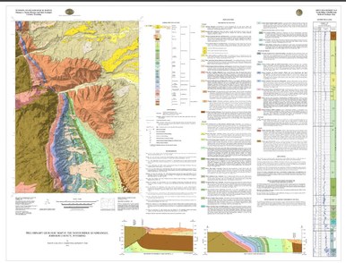
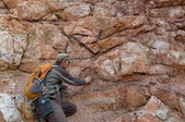
The WSGS has published three new geologic maps under its STATEMAP program.
These maps are vital for land management efforts and for the
exploration of Wyoming’s energy resources and minerals. Geologists’ field
research included gaining estimates of rock ages, which is important for
establishing the history of geological events. Read more...
|