| Follow Us: |
 
|
 |
|
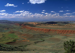
Red Canyon, Lander, Wyo. Photo courtesy of BLM.
|
By Chamois Andersen
Scientists and policymakers have frequently cited the phrase “public understanding of science.” In natural resource management, this is often associated with the public having knowledge of the science used to support management plans or policy initiatives, but more precisely, it relates to the creation of a more scientifically “literate” and better informed society…Read more.
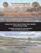
The WSGS completed its latest groundwater study on the Snake and Salt River basins in northwest Wyoming, as commissioned by the Wyoming Water Development Office.
Hydrogeologists rated aquifers in the Snake and Salt River basins as fair to very good in terms of the potential to meet expected groundwater resource demands in the next 20 years and well beyond.
The “Snake/Salt River Basin Water Plan, Available Groundwater Determination (2011-2014)” – 424 pages with color graphics and foldouts – is available on the WSGS website (click here).
|

National Highway Geology Symposium
The WSGS played a major role in the 65th annual Highway Geology Symposium, sponsored by WYDOT and held on July 7-10 at the Hilton Garden Inn/UW Conference Center in Laramie. The conference kick-off included a talk by WSGS hazards geologist Martin Larsen on Wyoming geology and current research by the agency. The focus of the meeting was an all-day field trip to the Snowy Range. The trip included eight stops around geological and geotechnical points of interest, as well as historical and cultural resources. Julie Francis of WYDOT provided the cultural talks, and WSGS geologist Seth Wittke and Larsen gave the talks on the geology of the Snowy Range and Laramie Basin.
Kids Camp at Vedauwoo
WSGS geologists this month provided elementary kids with a tour of the geologic wonders of Vedauwoo Recreation Area for the Summer Odyssey science camp, sponsored by UW’s Lab School. More than 50 campers participated in the half-day event, with activities facilitated by geologists on the 1.4 billion year old Sherman Granite, by Chris Carroll, the effects of erosion on the rock formations, by Karl Taboga, and the geologic timeline, by Martin Larsen.
|
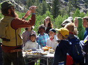
WSGS geologist Martin Larsen describes to kids how the geology of Earth's past has been organized into various units according to events which took place in each period, such as the creation of the rock formations found at Vedauwoo or the extinction of the dinosaurs.
|
|
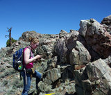
Geologist Elizabeth Cola conducts research for the bedrock geology map for McIntosh Meadows, Fremont and Natrona counties, Wyo.
|
|
 |
Statemap, a project under the U.S. Geological Survey, this summer has placed WSGS geologists once again in the field conducting research for developing and publishing the agency’s annual map series on Wyoming geology – maps illustrating the condition of rocks and deposits found on the surface of the land as well as bedrock geology for specific regional areas. The WSGS maps available to purchase this fall are:
1:24,000 scale Bedrock Geology of the McIntosh Meadows Quadrangle, Fremont and Natrona counties, Wyoming.
1:24,000 scale Bedrock Geology Map of the Northridge Quadrangle, Johnson County, Wyoming.
1:24,000 scale Surficial Geology Map of the Chicken Spring Area, Sweetwater County, Wyoming.
|