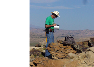
 WSGS geologist Wayne Sutherland investigating the titaniferous black sandstone horizon in the Mesaverde Formation at Cottonwood Creek in the Bighorn Basin. Photo by Judy Sutherland.
The Wyoming State
Geological Survey (WSGS) has received funding from the state Legislature to
study several mineral resources, including rare earth
elements (a continuation of a recent study), zeolites, lithium, and
iron. "We are pleased to receive this funding to study these minerals and to assist the state and industry in determining whether they are viable for exploration," Director Tom Drean said.
Rare Earth
Elements Investigation
The WSGS will take to the field again to continue its
efforts to sample and map locations of the state’s rare earth elements (REE),
with geologists also measuring and
recording REE abundances for potential exploration. This project is a
continuation of a recently completed study supported by the Legislature through
Abandon Mine Reclamation funds. The original study was published in 2013 (WSGS Report of Investigation, No. 65.)...Read more.
Zeolites Investigation
Zeolite is the name
of a group of more than three dozen naturally-occurring minerals used for a
wide variety of applications, from cat litter, to uses in the agricultural
industry.
The WSGS will investigate
Wyoming’s known and potential zeolite occurrences and deposits over the next
two years. Geologists will collect samples and analyze them using several
techniques...Read more.
|
Lithium Investigation
World demand for lithium
is expected to continue to rise in the coming decades. The soft silver-white
metal is used in batteries for cell phones and electric vehicles, ceramics and
glass making as well as high strength to weight metal alloys. Currently, Chile,
Australia, China, and Argentina produce most of the world’s lithium from hard
rock mines or groundwater brines.
WSGS geologists will evaluate the state’s lithium
deposits by analyzing lithium concentrations in selected rock formations, natural hot water springs, and
groundwater brines associated with existing oil and gas wells. The two-year
study will include a final report provided to the Legislature in 2016.
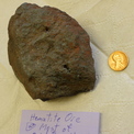
Iron
Investigation
The Wyoming Legislature has also allocated funds for the WSGS
to conduct an investigation of Wyoming’s iron resources. This will be the first
comprehensive study of iron by the agency. Recent interest
—
along with exploration drilling and claim staking in the state — has been driven by what
many perceive as new domestic needs for iron in the manufacturing
industry and particularly in creating heavy cement...Read more.
|
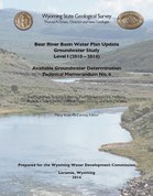
The WSGS, in
partnership with the U.S. Geological Survey, has completed its next groundwater
study for the state’s updated river basin plans, as commissioned by the Wyoming
Water Development Office.
The Bear
River Basin report has been expanded from previous technical reports and
provides a current assessment of the groundwater resources of the basin. The
report covers the Bear River drainage as well as tributary areas in Idaho and
Utah...Read more.
|
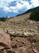
Landslides in Wyoming are common during
spring and early summer when a freeze-thaw process occurs causing soil
instability and fractures. Moisture can freeze in rock fractures and slightly
expand and widen those fractures. When the ice melts, additional water then
flows through the fracture, and then freezing and expanding again opens up the
fracture even more. Repeated freeze and thaw cycles can weaken the rock along
those fractures, which can then lead to rock falls and landslides. The added weight
of water on potentially unstable slopes can also cause slippage and landslides.
WSGS
has mapped more than 30,000 landslides in Wyoming, and maintains a database and
statewide map of these locations on its website.
|
Geologic Map of
Wyoming
The WSGS is soon to publish a statewide map based on its popular
selling geologic map of Wyoming. The map features different colors of the types and locations of
bedrock throughout the state.
The original map was authored by J.D. Love and Ann Coe
Christiansen and published in 1985 by the USGS. The revised version includes a new
layout and legend and is based on an updated GIS dataset that has been combined
with hill shading, slight color changes, and new base map information.
The Geologic
Map of Wyoming will be available in June as a printed 1:500,000 scale map, or
as a downloadable pdf from the WSGS website.
Gemstones Field
Guide
Due to popular demand, the WSGS is reprinting Gemstones and Other Unique Minerals and
Rocks of Wyoming, A Field Guide for Collectors. Copies will be available to
purchase in June for $25 via the WSGS online store or at headquarters on the UW campus.
New Summary
Reports
WSGS geologists have complied information on the locations and
production of Wyoming’s bentonite and trona resources. Summary Reports on each
one will be available as pdf downloads on the agency’s website in June.
WSGS Building
Renovation
The WSGS is undergoing a building renovation at its office location on the
campus of the University of Wyoming. The remodel includes new flooring, ceiling
tiles, and lighting. It also includes a new front counter for serving members
of the public who come in to purchase maps and other products.
Due to the construction, the sales desk and office be closed from Thursday,
April 17 until Monday, May 9.
|