|
Follow Us:
|


|
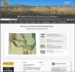
The WSGS website includes new content and multi-media platforms.
The Wyoming State Geological Survey (WSGS) has launched a brand
new interactive website for the agency,
along with improved navigation and a variety of downloads
on Wyoming’s geologic resources.
Main tabs include Energy, Hazards, Minerals, Water, Wyoming
Geology, Products, and Public Information. Each section contains basic
information as well as photos and graphics, with additional links to the more
technical science and applied research by the agency.
Highlights:
-
The Energy
pages include the latest production numbers for coal, oil and gas and
uranium.
-
The Hazards
pages include landslides and earthquake maps and infographics.
-
The Minerals
section covers mineral resources as well as "Wyoming Gemstones" with links to "Nephrite
Jade" and "Diamonds," some of the more popular pages of the agency.
-
The Water
section includes a state map with links to pdf downloads of the WSGS water
basin plans as well as information on Wyoming’s groundwater resources.
-
The Wyoming
Geology pages include the geologic history of Wyoming with a clickable time
scale in color.
-
The Geologic
Mapping section includes other tabs linking to downloadable bedrock and
surficial geology maps of all different sizes.
-
The Public
Information section includes all agency news and outreach programs,
including copies of our quarterly e-newsletter Geo-Notes as well as the Cultural Geology Guide...a statewide video project in progress.
Other products can be found on the WSGS Online Catalog, a clearinghouse of reports and maps published
by the agency. A new search feature is now included on the site for easy access
to items by topic.
Check out the new WSGS website at www.wsgs.wyo.gov. To sign up for WSGS news
releases or Geo-Notes, click here.
The WSGS will complete its
series of groundwater studies across the state with a final report on the
rivers of northeast Wyoming, slated for release in 2018.
WSGS hydrogeologists study
the distribution, flow and quality of Wyoming’s water underground. This
information is then complied, mapped and published by the agency.
The
WSGS has produced five major technical
reports
covering Wyoming’s major river basins in the state, including the Snake/Salt
River Basin, Bear River Basin, Wind/Bighorn Basin, Greater Green River Basin
and Platte River Basin. The final groundwater study will include the Powder,
Tongue, Belle Fourche, Cheyenne, Niobrara and Little Missouri rivers.
These
projects are funded by the Wyoming Water Development Office and include
groundwater data, maps and analyses. The scientific information compiled for
these studies are then incorporated into the state’s major water plans. Such
collaboration between state agencies is important for managing the future use
of Wyoming's water resources.
The
WSGS studies cover the geologic conditions of the water basins, water quality,
and the natural storage of water in the underground aquifers. Locally, water
from snowmelt infiltrates through the ground to recharge the underlying
aquifers that residents use for their groundwater supplies.
Groundwater
is especially important in the arid West where surface water is not as ample as
in other parts of the country. Both groundwater and surface water provide
freshwater for a wide variety of uses, from the water we drink to water used by
livestock and wildlife.
Wyoming
is an important headwaters state that supplies this finite resource to some of
the nation’s largest rivers. The state’s mountain snowpack is an important
source of natural water flows that ultimately discharge into the Colorado,
Missouri and Colombia Rivers as well as the Great Salt Lake Basin.
Check
out the new WSGS Summary Report on Wyoming’s
Groundwater Resource, a four-page synopsis with maps and
information.
|
|
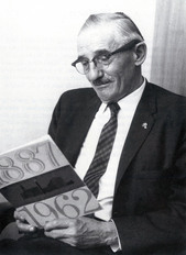
“Wyoming is a geologic
showplace, a panorama of windswept basin floors and imposing mountains.”
~
Samual Howell Knight “Doc”
(To view a video of one Dr. Knight’s final lectures on Wyoming geology, click here. Courtesy of the UW Dept. of Geology and Geophysics.)
Known as “Mr. Geology of Wyoming,” Dr. Sam Knight was a
professor and head of the geology department at the University of Wyoming until
he retired in 1963. Knight
taught more than 10,000 students throughout his career and was known to them as
“Doc.”
In 1925, Knight
established the UW Science Camp, a geological camp in the Medicine Bow
Mountains west of Laramie that attracted students from all over the country.
The camp was named after him in 1966. Knight
continued teaching as professor emeritus until 1966. During his 60 years at UW, he expanded the
geology department and helped make it a nationally recognized program.
Knight
was famous for his 3-D drawings, and his ability to draw a perfect circle—
freehand— on the classroom blackboard. His “chalk talks” became well known with
his use of colored chalk to draw block drawings that vividly depicted
and expounded on the physical evolution of Wyoming he discussed during his
classes. The following text details a “chalk talk” by Knight, an excerpt by
Brainerd Mears (1990).
Knight lectured on how Paleozoic and Mesozoic seas advanced
and retreated across the continental platform, depositing sediments. As the
Cretaceous seas withdrew, “broad-backed anticlines arose and wide synclines
subsided” to initiate the Cenozoic structural framework of Wyoming’s mountains
and basins.
The rising mountains were eroded, exposing the Precambrian
basement complex in their cores. Concurrently, the basins were filled with
debris from the mountains, greatly supplemented by “vast clouds of volcanic ash
drifting in from remote sources.”
Subsequent cycles of erosion, transportation, and deposition
modified the late Tertiary landscape. Near the conclusion of his presentation
Knight said, “ice sculpted the final scene” as Pleistocene glaciers flowing
down pre-existing stream valleys in the mountains scoured great U-shaped
troughs and deposited hummocky horseshoe-shaped moraines on the adjacent
plains.
Generalized
Geologic Map of Wyoming (pdf download)
|
WSGS is soon to release a plate showing
a series of stratigraphic cross sections of the Fort Union and Lance formations
in the Great Divide Basin. As part of the WSGS energy assessments, geologists
Ranie Lynds and Chris Carroll have been gathering data and creating a
stratigraphic model to gain a better understanding of the clastic depositional setting
around the Late Cretaceous and Early Paleocene time interval. This project is
intended as original research that uses subsurface data to design a
stratigraphic architecture for potential coal, oil, and natural gas resource
development in the northeast part of the Greater Green River Basin.
|
Are you on social media? If not, you can still see our
weekly Geo-Note posts online at www.facebook.com
/Wyoming.Geological.Survey.
Each Friday we provide a new post on something geologically fascinating. This
includes geology tidbits on Wyoming as well as for other locations around the
nation and the globe.
Included in each week’s post is an eye-catching visual such
as a photo or infographic. The most popular Geo-Note
to go “viral” was a post about the Geologic Time Scale. We featured a colored
infographic showing the various stages of geologic time along with the associated
animals and fossil records. This post went to more than 3,000 viewers. Our
weekly Geo-Note post is a great way for
our agency to reach a broad audience interested in geology.
|
|
 |
 |
|
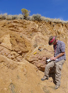
Geologist Jacob Carnes taking field notes for a WSGS minerals investigation. |
Click here for full project descriptions...
- STATEMAP
- Mineral Investigations (iron, rare earth elements, zeolites,
lithium)
- Phosphate study
- Saline waters report
- National Coal Resource Data System
- Wyoming oil and gas online map
- Unconventional oil and gas research
- Karst
- Water atlas
- Geologic hazards report
|