|
Follow Us:
|


|
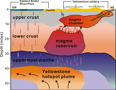 This cross-section illustration cutting southwest-northeast under Yelowstone depicts the view revealed by seismic imaging. Graphic by Hsin-Hua Huang, University of Utah.
 University of Utah scientists discovered a new magma reservoir
underneath Yellowstone. The reservoir of partly molten rock is 12 to 28 miles beneath the Yellowstone supervolcano, and it is 4.4 times larger than the shallower, known magma chamber.
The discovery of an additional magma reservoir does not increase the risk of an eruption, says scientists. But they now have a better picture of Yellowstone’s volcanic system using new techniques and imaging.
This plumbing system supplies hot and partly
molten rock from the Yellowstone hotspot to the supervolcano. The magma
chamber, which lies on top of the reservoir, actually draws magma from
the reservoir and is responsible for fueling the geysers of Yellowstone.
This includes the Norris Geyser Basin, the hottest, oldest, and most
dynamic of Yellowstone's thermal areas.
This new science will provide
experts with a better understanding of these complex crustal systems. It
will also help them to better understand Yellowstone's past eruptions
(spanning 2 million years), some of the largest on earth! This research
was published in the journal Science.
|
 In
Wyoming, beauty in nature abounds. But with that wild beauty can come natural hazards.
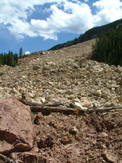
The major geologic hazards in the state are earthquakes and landslides. In 2014, there were 49 earthquakes with magnitudes greater than 2.5 in Wyoming; 20 had magnitudes greater than 3.0, with 17 of those events in Yellowstone.
While earthquakes and landslides can pose a risk to people, property and infrastructure, Wyoming
is fortunate to have such a rural population, minimizing this risk. However, it is important to have an understanding of the types of
hazards we do have and where they have historically occurred, to be prepared. This is especially true for landslides during
spring.
Landslides are most common during
spring and early summer when a freeze-thaw process can cause soils to become unstable and rocks to fracture. Repeated freeze and thaw cycles can weaken the
rock along those fractures, which can cause rock falls and landslides. To learn more about the types of landslides
we have, log on to the WSGS Landslides page.
Check out the new WSGS Summary
Report on Wyoming’s Geologic Hazards,
with detailed information landslides as well as the state's historic earthquakes and Yellowstone.
|
WSGS oil and gas
geologists are in the process of developing the next generation of the Oil and Gas Map of
Wyoming. This map is one of the most popular products published by the agency,
and in high demand by members of industry, researchers, policy makers and the
general public.
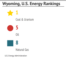
Wyoming is a leading
producer of oil and gas in the nation. The state ranks fifth in natural gas and
eighth in oil. Nearly all of the state’s oil and gas is shipped via pipeline to
market. Pipeline sizes, operators and locations are all illustrated on the map, along with other oil and gas data.
Geologists use geographic information system (GIS) technology to
create various layers of information, from oil and gas geology to extractive activities. Other features on the
map include:
-
Boundaries
of producing and abandoned oil and gas fields in Wyoming
-
Producing
(or produced) formations
-
Dominate
age of reservoir rocks
-
Field
designations
-
Refinery
and gas plant locations and capacities
-
Basin
locations
-
Extent
of oil shale-bearing rocks
-
Railroads
The current version of the Oil and Gas Map of Wyoming is available as a free pdf
download or for $50 in a large printed format via the WSGS catalog.
The agency also plans to create an online
version of the oil and gas map, which will include additional spatial data not easily displayed on the
paper version. The online map will be interactive with various layers of
information to select for viewing.
For information, or if you have suggestions on
the next generation of the Oil and Gas Map of Wyoming, please email Rachel Toner (rachel.toner@wyo.gov) or Ranie Lynds (ranie.lynds@wyo.gov).
|
While groundwater is an important freshwater resource, not all groundwaters are suitable for domestic, livestock or
agricultural uses. Much of Wyoming’s groundwater contains concentrations of salts
that exceed 10,000 parts per million (ppm). For comparison, seawater has a salt
concentration of 35,000 ppm.
A new
WSGS study focuses on these saline waters, which naturally occur in numerous deep rock
formations in the state. Saline groundwaters can be utilized for energy and industrial
development. The WSGS is compiling water data to determine the locations of
saline groundwater within each river basin.
A final report will detail saline waters and the formations that
contain these waters. A series of maps will complement the study with locations of the
areas within each basin where saline waters occur. This information will be
particularly useful to energy resource and industrial developers that can use lower
quality groundwater in their operations and better conserve Wyoming’s
fresh groundwater resources. This report will be available this
fall.
The Meade Peak Shale Member of the Phosphoria Formation hosts many of the high-grade phosphate rock beds in Wyoming. WSGS photo by Brett Worman.
Phosphate rock is used to produce phosphorus fertilizer, an
important and necessary component of industrial-scale agriculture. Demand for
phosphate rock is projected to increase as the earth’s population grows.
The
United Nations Food and Agriculture Organization estimates that global fertilizer
consumption will increase 25 percent by 2050. Wyoming is well situated to add
to the global production of phosphates, as many of the state’s high-grade
occurrences are located in the overthrust belt, relatively close to existing
processing infrastructure in Rock Springs, Wyoming, as well as in southeastern
Idaho and northeastern Utah.
Phosphates typically occur as the
mineral apatite, and can be found in sedimentary, igneous and metamorphic
rocks. In Wyoming, the most important
phosphate occurrences are hosted in the marine shales of the Permian Phosphoria
Formation. Some igneous and metamorphic rocks rich in iron, titanium and/or the
rare earth elements may also host significant phosphate occurrences. Relatively
minor concentrations of phosphates occur in the lacustrine sediments of the
Wilkins Peak Member of the Green River Formation.
This
project seeks to highlight potentially economic phosphate occurrences
throughout Wyoming. A compilation of historical data from
phosphate deposits across the state will be supplemented with data from samples
to be collected by WSGS geologists in spring and summer 2015. X-ray diffraction and whole-rock geochemical
analysis of these samples will be used to determine the amount and type of
phosphates present. Results of this investigation will be published by the agency in November
of 2015.
The
WSGS is providing important data on the state’s coal resources to a central
clearinghouse for the nation.
The National Coal Resource Data System (NCRDS)
provides information on the location, quantity and physical and chemical
characteristics of U.S. coal and coal-related deposits, a national database
administered by the U.S. Geological Survey (USGS).
The
WSGS has participated in this program for more than 30 years, along with other geological surveys in states with coal resources.
The mission of NCRDS is to collect
stratigraphic and coal quality information about each state's coal resources
and to upload the information into a national database for strategic
information purposes. This database provides a central source of information
used to determine the amount of coal remaining (in-place), as well as data
on the types of coal, characteristics related to coal quality, and depth and
thickness data.
The
WSGS has entered more than 26,000 points of stratigraphic information into
the database, to date. Over 22,000 of those points are from coalbed methane wells
in the Powder River Basin. WSGS coal geologists are currently working
on an additional 6,000 points of information in the Great Divide Basin
area of the Greater Green River Basin. These geologists are focused on the uraniferous coals of the Eocene Wasatch Formation and the
mineable subbituminous coals of the Paleocene Fort Union Formation.
The National
Coal Database System is available on the USGS website. The
Wyoming portion of this national database will be available soon via the WSGS
coal website.
|

The
WSGS received a grant from the Wyoming Cultural Trust Fund to create a cultural
geology guide, designed for road travelers and online users.
The Origin of Landscape: A Guide to Wyoming's Cultural
Geology will cover
a niche area in tourism, intelligent travel. Users
will be able to see and virtually explore the nexus between geological
phenomena, landscape and cultural beginnings.
This
program will include an interpretive guide
(with mobile tags) along with its online counterpart, a website featuring
stories, interactive maps, photos and videos of experts in the field.
This program is for residents and
tourists who want to learn more about the landscape they are traveling through, and for anyone who wants to learn more about Wyoming's the culture and geology.
The WSGS, Wyoming Department of
Transportation and Wyoming Office of Travel and Tourism have partnered for this
intelligent travel program. The guide will be available at the state’s Visitors
Centers this fall, along with the launch of the online program via the WSGS.
|
|