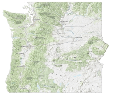
Public lands in Washington and Oregon. (Source:
Atkins Global)
The Pacific Northwest is home to a vast network of public
lands served by complex, multimodal transportation systems. Federal Land
Management Agencies (FLMAs) in Oregon and Washington often have similar
partners, geographic and social planning contexts, and interrelated transportation
networks. These connections offer the potential for mutual benefits through
collaborative transportation planning among FLMAs and with state and local partners.
To achieve greater coordination, the Federal Highway Administration Office of
Federal Lands Highway (FLH), the Bureau of Land Management (BLM), National Park
Service, U.S. Army Corps of Engineers (USACE), U.S. Fish and Wildlife Service,
U.S. Forest Service (USFS), and state and local transportation agencies in Oregon
and Washington are working together to develop a Collaborative Long-Range
Transportation Plan (LRTP) for federal lands in the Pacific Northwest.
This Collaborative LRTP is the first effort for long-range
planning that covers multiple states and includes multiple FLMAs. It will help FLH
and FLMAs meet planning requirements from the Moving Ahead for Progress in the
21st Century Act (MAP-21). MAP-21 requires FLMAs to conduct
transportation planning that is consistent with metropolitan and statewide
planning processes. MAP-21 also encourages multi-agency collaboration to
establish common transportation planning goals and coordinated strategies to
reach those goals.
The Collaborative LRTP, which builds on the success of the
recently completed Alaska Federal
Lands LRTP, will engage the involved agencies in setting joint transportation
priorities, collecting data common to multiple agencies, and identifying common
strategies to meet transportation needs for the Pacific Northwest’s federal
lands. As part of the Collaborative LRTP, the BLM, USFS, and USACE will also create
agency-specific templates to use in developing future LRTPs in other regions.
Volpe is helping FLH in this effort by facilitating project
meetings and supporting the creation of the project’s work products. These
products include a multi-agency LRTP for the Pacific Northwest region;
agency-specific drop-down plans; templates for BLM, USACE, and USFS regional
LRTPs; and data collection and coordination to support federal lands long-range
transportation planning. Volpe worked with FLH to organize a kick-off meeting
for project participants in Vancouver, WA, in December 2013, facilitates
monthly team meetings by webinar, and will participate in the upcoming
multi-agency meeting in Bend, OR, in May. The project participants expect to develop final
Collaborative LRTP work products by 2015.
Project contact: Haley
Peckett
Climate
science and recent weather events have pointed to flooding as the most
immediate and severe climate threat facing transportation in the Northeast. As
part of its first Long-Range Transportation Plan, the Northeast Region Office
(NERO) of the National Park Service (NPS) identified “adapting park
transportation resources to increase resilience to climate change” as a key
objective. To help NPS increase the resilience of its transportation system, Volpe
is supporting NERO in identifying and responding to flood-threatened
transportation facilities.
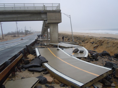
Damage to a multi-use path at Sandy Hook from Hurricane
Sandy. (Source: NPS)
Working with
NERO and park units, Volpe is assessing current asset vulnerability using
geospatial data and Federal Emergency Management Agency (FEMA) flood zones. The
resulting base layer of vulnerability will be of immediate use to regional transportation
staff as an additional factor for consideration in their ongoing planning and
programming processes. Volpe is also researching techniques and data for
modeling future flood vulnerability in the Northeast Region and gathering
strategies from peer agencies for managing flood-vulnerable assets. These
products will help NERO assess future vulnerabilities that may increase as a
result of climate change, and build resiliency into Northeast Region
transportation systems.
To make the
region’s response to flood vulnerabilities more effective, Volpe is also
helping NERO better define its evolving transportation planning and programming
processes. The final report will provide information on current and future
flood vulnerability at a high level, a compendium of strategies that can be
applied under various circumstances, and suggestions on how to systematically
incorporate flood resiliency into NERO’s standard practices. The report will
also highlight areas in need of further study.
Project contact:
Kevin McCoy
In April, Volpe delivered the final report for an
alternative transportation feasibility study at Mount Baker-Snoqualmie National
Forest (MBSNF) in Washington State. MBSNF, located northeast of Seattle, is one
of the most visited National Forests in the country and faces heavy parking lot
congestion due to popular summer and winter recreational opportunities. Forest
Service staff also seek to provide better alternative transportation access to
MBSNF sites for the growing, diverse populations of Seattle and the Puget Sound
region. To address these concerns, Volpe
has worked closely with MBSNF staff and the Western Federal Lands Highway
Division since 2011 to study alternatives to manage parking congestion and
expand alternative transportation access at the Forest. Volpe’s final report
focuses on improvements to traveler information as well as transit opportunities
in the Interstate 90 corridor in King County, Washington.
A robust traveler information system allows visitors to make
informed decisions based on traffic and road conditions, facility closures,
weather conditions, parking, and alternative transportation options. While
sources of traveler information related to the Forest are abundant, the project
team identified several gaps in the system. The final report recommends a set
of strategies to address these gaps and improve traveler information. Volpe
also developed a new way for MBSNF to show when roads and trails are opened or
closed using web-based interactive maps.
In addition to traveler information strategies, Volpe’s report
provides three preferred alternatives for transit service in the I-90 corridor.
The preferred alternatives will help MBSNF manage visitation at some of its
most popular sites. They are also designed to work with existing transit
service to form a regional transit system that serves many unique recreational
destinations along I-90, including those outside MBSNF.
As an alternative to traditional transit, Volpe also
investigated the concept of a shared-use vehicle program. This type of program
involves multiple non-profit organizations working together to acquire and
share a van or bus for excursions to the Forest and elsewhere. MBSNF hopes to
promote this concept as a way to increase access for underserved populations
who may be more likely to visit the Forest as part of an organized outing.
Project contact: Benjamin
Cotton
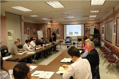
Stakeholders discuss safety on the B-W Parkway this
April in Landover, Maryland. (Source: Volpe)
Built as an alternative to U.S. Route 1, the
Baltimore-Washington (B-W) Parkway opened in 1954 as a limited-access scenic
highway owned and operated by the National Park Service (NPS). Today, the B-W
Parkway serves as both a scenic gateway to the nation’s capital and a major
commuter corridor. Increased commercial development accessed by the Parkway has
resulted in significant daily traffic volumes and associated congestion and
safety issues. The Parkway averages multiple accidents every day, and an
average of seven traffic fatalities occurred annually on the Parkway over the
past five years. For this reason, the NPS National Capital Region (NCR) has
identified the B-W Parkway as a top priority for safety improvements.
Volpe is supporting NCR to develop the B-W Parkway Traffic
Safety Plan, which will identify opportunities to improve safety on the B-W
Parkway. This plan will incorporate the “4Es”—Enforcement, Education, Emergency
Services, and Engineering—as strategies for traffic safety. The goal for the
plan is to develop a list of actionable items and projects to reduce fatalities
and serious injuries.
In February and April, Volpe assisted NCR at two outreach
sessions for stakeholders from NPS, the Federal Highway Administration, the
National Highway Traffic Safety Administration, the U.S. Fish and Wildlife
Service, regional governments, the Maryland State Highway Administration, local
employers, and organizations involved in traffic safety advocacy, enforcement,
and policy. The most recent activity was an in-person workshop this April in
Landover, Maryland, which was attended by over 25 stakeholders. Breakout
sessions during the meeting resulted in a number of innovative ideas that the
team will summarize for the Plan. The
B-W Parkway Traffic Safety Plan is expected to be finalized in late summer
2014.
Project Contacts: Susan
Smichenko and Ryan Yowell
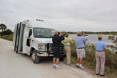
Merritt Island National Wildlife Refuge, located in
Titusville, Florida, serves as a regional destination for approximately 1
million visitors annually. Home to over 500 species of wildlife and 1,000 species
of plants, the Refuge is unique for its proximity to the Kennedy Space Center
and Canaveral National Seashore. A major birding destination, the Refuge
experiences seasonal congestion at high-use visitor sites, most notably Black
Point Wildlife Drive. Refuge staff also recognize the opportunity to expand
access to new user groups and serve visitors in a more sustainable manner
through transit service.
To help address these concerns, Volpe is supporting the
Refuge and its partners to develop a transit planning study. The study will
identify transit service options using the Refuge’s current 14-passenger bus
and evaluate the potential for enhanced transit access to the Refuge over the
next 20 years. As of April 2014, the Refuge and Volpe have met with local and
regional stakeholders and drafted a short-term transit plan, and are currently
crafting scenarios for long-term transit. Funded by a grant from the Paul S.
Sarbanes Transit in Parks program, the final report is expected in the summer
of 2014.
Project contacts: Haley
Peckett and Ryan Yowell
The Bureau of Land Management (BLM) owns and manages 247
million acres of land across the western U.S., which contain over 400,000 route
miles of motorized and non-motorized travel routes. Many of these routes intersect
with critical regional transportation networks and provide access for diverse
users on BLM lands. These routes also have the potential to impact sensitive
species. However, most of these routes have not yet been inventoried. The BLM
uses Travel and Transportation Management Plans (TTMPs) for each of its field offices
to inventory, document, and map existing and planned transportation facilities
and routes and identify future needs. As of 2012, however, the BLM had only
completed 131 TTMPs (out of 633 total) due to staff and funding limitations. The
BLM has a need for a prioritized plan to complete these TTMPs and connect them
to the BLM’s larger transportation program mission.
To help the BLM complete its TTMPs, Volpe recently supported
the BLM to develop its 2020 Travel and Transportation Management Vision. The
Vision provides the BLM with a strategy for completing all of its TTMPs by
providing the status of each state office’s plans and setting a goal to
complete 75 percent of all TTMPs by 2020. The BLM’s strategies for completing
TTMPs include setting targets for each state and improving coordination among
BLM divisions. One chapter of the Vision lists state-by-state partners and
critical issues, like sage grouse and energy development. The BLM hopes to use
the Vision document to communicate its need and priorities for transportation
planning to its staff and partners across and the country.
Project contact: Haley
Peckett
In March, Volpe facilitated a Transportation Assistance
Group (TAG) meeting at the Great Dismal Swamp National Wildlife Refuge (NWR). The refuge is nestled between historic
Williamsburg, Virginia and the Outer Banks of North Carolina. It offers many
natural and historic resources, as well as activities such as hiking, biking,
fishing, bird watching, and hunting. The Great Dismal Swamp is also the only
National Wildlife Refuge designated as an important landmark on the National
Underground Railroad Network to Freedom. Although the refuge lies between the
growing cities of Chesapeake and Suffolk, Virginia, the majority of the 60,000+
annual visitors are from outside of the local area. The difficulty of access to
the refuge has been identified as a potential barrier to higher local
visitation rates. The Chesapeake side of the refuge is particularly isolated
due to the Dismal Swamp Canal, which is part of the Intracoastal Waterway
operated by the U.S. Army Corps of Engineers.
The goals of the TAG are to identify transportation issues
affecting the Great Dismal Swamp NWR and opportunities to enhance access to and
within the refuge. TAG participants included Volpe, FWS staff, FHWA Eastern
Federal Lands staff, the US Army Corps of Engineers, and representatives from
the Cities of Suffolk and Chesapeake. Together, the group developed a number of
promising ideas for enhancing alternative transportation access to the refuge,
such as bicycle access improvements, communications strategies for the local
population, and opportunities to partner with the Cities of Suffolk and
Chesapeake. Volpe is currently drafting a report that will summarize the
recommendations from the TAG meeting and provide information about resources
for implementation.
Project contact: Heather
Richardson
|