|
The streams of the Salt River Watershed, including the North Fork Salt, South Fork Salt, Elk Fork, Indian Creek, Lick Creek, and several others drain into Mark Twain Lake which is located in Monroe and Ralls counties in northeast Missouri. The watershed of Mark Twain Lake includes the headwater creeks and streams in parts of 11 counties in Northeast Missouri, including Schuyler, Adair, Macon, Knox, Shelby, Randolph, Monroe, Boone, Callaway, Audrain, and Ralls counties.
Clarence Cannon Dam was authorized by the Flood Control Act of October 1962 and construction of the dam was completed in 1984. The purpose of the project was to provide for multiple uses, including hydroelectric power, flood control, recreation, fish and wildlife conservation, water supply, and control of water levels for navigation downstream on the Mississippi River. At normal pool, the lake provides 18,600 acres of surface water and 285 miles of shoreline. The dam, which is 1,940 feet long, is capable of producing up to 58,000 kilowatts of power, enough energy to power a town of 20,000 people.
Recreational opportunities at Mark Twain Lake include camping, picnicking, hiking, equestrian trails, hunting, a shooting range, swimming, boating and fishing. There is approximately 55,000 acres of land and water available for public use at the lake. The U.S. Army Corps of Engineers manages Mark Twain Lake and its surrounding public property. The M.W. Boudreaux Memorial Visitor Center, located adjacent to Clarence Cannon Dam, opened in 2010, and has area visitor information, exhibits, nature trails, and a Northeast Missouri Vietnam Memorial. To learn more about the Army Corps recreational areas and programs at the lake, visit http://www.mvs.usace.army.mil/Missions/Recreation/MarkTwainLake.aspx.
Mark Twain State Park and State Historic Site are also located at Mark Twain Lake at Florida, MO. The state park provides camping, boat access, a swimming beach, a group camp, and park programs throughout the year. To find out more about recreational areas and activities at Mark Twain State Park, visit http://mostateparks.com/park/mark-twain-state-park. At the Mark Twain State Historic Site, you can see the two bedroom cabin where Samuel Clemens (Mark Twain) was born, a handwritten manuscript of the Adventures of Tom Sawyer, and items and furnishings from Twain’s residence. More information about the state historic site can be found at http://mostateparks.com/park/mark-twain-birthplace-state-historic-site.
Two marinas, Blackjack Marina and Indian Creek Marina, are located on Mark Twain Lake and provide boat slips and rentals.
In addition to energy supply, recreation and tourism, Mark Twain Lake is also an important water supply source for northeast Missouri. Clarence Cannon Wholesale Water Commission (CCWWC) was established in 1983 and production and sale of water began in 1992. The water treatment plant is located on the North Fork Salt River Arm of the lake near Florida, MO and is capable of treating 10 million gallons of water per day. CCWWC provides clean drinking water to 14 counties in northeast Missouri, which includes fifteen cities and nine rural water districts that are members of the CCWWC.
 Mark Twain Lake at Buzzard's Roost Picnic Area at Mark Twain State Park.
In late April and early May of this year, students at Truman State University organized a stream restoration project for Bear Creek, a stream that flows through campus and is a tributary to the North Fork of the Salt River. The students planted a rain garden and 300 trees within the stream’s riparian zone. The goals of the project include improving the aesthetic beauty of the stream, slowing and absorbing storm water flows after rain events, attracting wildlife and pollinators, and improving water quality and aquatic life in the stream. The students also requested that the area next to the stream be a “no-mow” and “no-spray” zone, which will help a buffer of taller vegetation grow and reduce erosion along the banks.
The project was sponsored by campus student groups including Beta Beta Beta, ECO, PLANTS, Beta Omega Beta, and Student Senate. Trees for the project were provided by the Missouri Department of Conservation. The campus advisor for the project is Clayton Dillavou, a visiting scientist who helped with selection and growth of plant seedlings. The students hope that their project can serve as a local demonstration of a stream improvement project that will be visible to students, parents, and visitors to campus.
The students and faculty are also interested in monitoring the water quality, stream flow, and aquatic life in the stream to measure improvement in the stream after the project, and the Missouri Department of Natural Resources has assisted in providing guidance for their monitoring plan. More information about rain gardens and the benefits of stream riparian buffers can be found at the Watershed Committee of the Ozarks website at http://watershedcommittee.org/our-publications/. If you are interested in planting a rain garden or improving a stream in your community or at your school, contact your regional watershed coordinator, Mary Culler at 660-385-8000 or Mary.Culler@dnr.mo.gov.
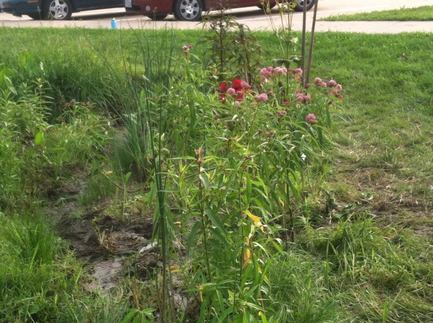 This rain garden was planted by students at Truman State University during the spring of 2014 to slow and absorb storm water runoff. The garden also attracts pollinators like Monarch butterflies. The rain garden is built in a low area that drains to Bear Creek, a tributary of the North Fork Salt River.
On May 20, 2014, staff from the Missouri Department of Natural Resources’ Northeast Regional Office in Macon hosted the Salt River Watershed Festival at the Si Colburn Camp at Mark Twain State Park. Fourth, fifth, or sixth grade classes from Middle Grove Elementary, Monroe City, Paris, Perry Christian, and Van-Far Elementary attended the festival. There were approximately 160 students and ten teachers/chaperones that attended the event. Students rotated through 10 different learning stations, which included interactive activities related to fish of the Salt River basin, aquatic macroinvertebrates, Missouri Stream Team water quality monitoring, boating safety, treating safe drinking water, asbestos, recycling, environmental emergency response, and native plants. The students also walked through a watershed journey activity where the students were raindrops that picked up various pollutants and carried them downstream from tributaries of the Salt River to the Mississippi River, and then into the Gulf of Mexico. In addition to staff from the Missouri DNR office in Macon, staff from the Missouri DNR Environmental Emergency Response Unit from Jefferson City, the Missouri Department of Conservation, and the Army Corps of Engineers taught learning stations. The Salt River Master Gardeners volunteer group also taught the station about native plants and provided free plants to the students. Staff from Mark Twain State Park provided set-up and assistance for hosting the event at the park’s Si Colburn Camp.
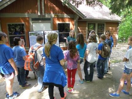 4th, 5th, and 6th grade students from schools within the Salt River Basin stop at an education station to learn about water quality monitoring and the Missouri Stream Team Program.
by Pat Guinan, MU-Extension State Climatologist
The National Weather Service (NWS) maintains a national network of weather stations that has been operational for well over a century. Specifically, the NWS Cooperative Observer Program was established in 1890 and today consists of more than 8,000 volunteers who report daily weather observations, mostly air temperature and precipitation. It’s because of this program, the United States has one of the best monitoring networks in the world. One of the premises of the cooperative program was to define the climate of our country, as well as discern long-term trends. There are nearly 200 active cooperative observers in Missouri and one of the most notable and recent climatic trends experienced in our state involves precipitation, and a lot of it!
The figure below shows annual average statewide precipitation in Missouri over the past 119 years, or since 1895. A 5-year trend line reveals several wet periods that have dominated since the early 1980s. The wet pattern has also been accompanied by an increasing trend of heavy precipitation events. The historic data provides context, and it’s interesting to note Missouri has not experienced an extended multi-year dry period in more than 50 years. The 5-year period 1952-56 is considered the mother of all droughts in our instrumental record, and incredible hardship was incurred during this time, as well as the Dust Bowl years in the 1930s. Tree ring analyses conducted in Missouri for millennia indicate periods of multi-year severe droughts. Predicting when this current wet period will end is difficult to say, but I am confident in predicting that extended dry periods will return, and it’s important to ask ourselves, are we ready for them?
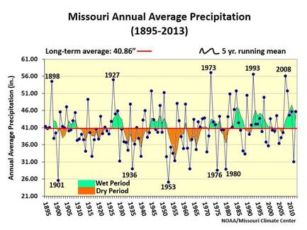 This graph shows the 119 years of precipitation for the state of Missouri. Note the multi-year wet periods that have occurred since the early 1980's and the multi-year dry periods that occurred in the 1930's and 1950's.
by Kelly Srigley Werner, USFWS Missouri State Private Lands Coordinator
In the Midwest, soil conservation is important for agriculture and Missouri is exploring ways to keep soil on the field through cover crops in winter. In Iowa a technique that is showing promise during the growing season could also help Missouri.
The STRIPs project (Science-based Trials of Rowcrops Integrated with Prairie strips) has been introduced by Iowa State University in partnership with scientists, landowners, extension specialists and educators, to find ways to insure agricultural lands are sustainable and provide good conservation services.
The STRIPS practice involves planting diverse prairie grasses and flowers in strips along a contour in the most vulnerable areas of a crop field (i.e., those areas that could be erosive). It has been shown that converting just 10% of a crop field helps reduce the amount of soil leaving the land by 90%. In addition, this practice reduces the amount of nitrogen leaving the field by 85%. Similar to buffer strips around a field, this practice is also beneficial to pollinators like the monarch butterfly and other beneficial insects and prairie dependent song birds, but more importantly, the practice is affordable for landowners.
How? Prairie strips have deep roots (some up to 20 feet) that hold soil in place. Planting a diverse mix of species provides nectar sources for bees, butterflies and other beneficial pollinators and provides bugging areas for declining grassland birds and some nesting opportunities.
What’s the big deal about Monarchs? The Monarch population is declining precipitously. This species is the only migrating butterfly and loss of habitat, specifically, milkweeds and nectar plants in the Midwest are contributing to the decline. By working to incorporate small areas of a farm field into prairie strips we can provide much needed habitat for pollinator species and help save the monarch together.
For more information about Prairie Strips please visit this website: http://www.nrem.iastate.edu/research/STRIPs/
If you think you would like to work on incorporating STRIPs on your land, contact Mary Culler at 660-385-8000 or Mary.Culler@dnr.mo.gov or your local county conservation service center. Funding may be available for cost-share or incentives for this practice.
Your local Soil and Water Conservation District offers cost-share on many different practices that prevent or control soil erosion and nutrient runoff as well as protecting water quality. Here are a few practices that could be very beneficial to your farm both economically and environmentally. Cost-share helps pay a portion (up to 75%!) of the landowner’s costs to help landowners implement practices that they want to do on their land.
N386 – Field Border
This conservation practice reduces soil loss and improves water quality by preventing excess sediment and nutrients from entering streams.
·Applies around the perimeter of fields
·Can support or connect other buffer practices within and between fields
·Eligible for a $600 per acre incentive payment for acres converted from cropland to permanent vegetative cover
·Landowners can receive cost-share assistance up to 75% of the state average cost for critical area seeding
·Field borders can be hayed or mowed
·Limited grazing is allowed as incidental use when crop field residue is being grazed
·There is a 10 year maintenance agreement for this practice
N393 – Filter Strip
This conservation practice establishes permanent grass filter strips below crop, hay and grazing land to prevent sediments, chemicals and nutrients from entering sensitive areas or water bodies.
·Applies to areas situated below cropland, hay land or grazing land
·Eligible for a $1,000 per acre incentive payment for acreage converted from cropland to permanent vegetative cover
·Landowners can receive cost-share assistance up to 75% of the state average cost for exclusion fence and critical area seeding
·There is a 5 year maintenance agreement for this practice
If you have any questions about these or other conservation practices, contact your local Soil and Water Conservation District office.
by Bob Broz and Joe Koenen, MU Extension
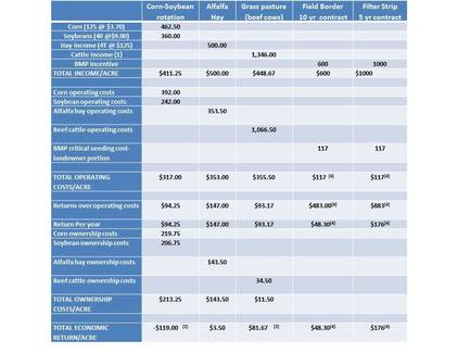
Economic Comparison of Annual Crops vs. Grass
Farmers and landowners have to decide which crops not only make the most sense from an economic standpoint but also in conserving their land and water resources. These decisions are difficult due to changing prices and costs as well as other factors. So let’s look at a comparison of several practices common in North Missouri.
For a larger version of this table, please contact Mary Culler at Mary.Culler@dnr.mo.gov.
Based on these figures (2015 Missouri Farm Financial Outlook) and looking at the total economic return/acre per year, crop ground has a negative return of -$119.00/acre and is the lowest total economic return, followed by $3.50/acre for alfalfa hay, followed by $48.30/acre for field border. Cow-calves and filter strips were the highest total economic return/acre, at $81.67/acre for cow-calf operations and $176/acre for filter strips. The bottom line is: look at your specifics for your farm to determine your situation but don’t assume that crops return more than any other land use, especially under the new Farm Bill.
{1} cattle income includes ½ steer and heifer x 84% plus portion of cull cow income. {2} based on ½ acre each for a corn soybean rotation.
{3} based on a cow unit and 3 acres per cow.{4} These acres can be mowed or hayed. Operating costs/return does not include cost or income from mowing or haying field border or filter strip, so these values will vary depending on the management of these acres.
** Other assumptions are hay or grass is already established and figures based on current prices and conditions which can and will change. Cost-share may be available to reimburse a portion of the cost to seed down ground. Also assumes highly erodible ground (waterways, close to creek) yields equal to other land which is not realistic.
CRP can improve your bottom line, reduce soil loss, and improve water quality
by Casey Bergthold, Northeast Missouri’s Quail Forever Farm Bill Wildlife Biologist
It seems strange to think of the Conservation Reserve Program (CRP) as an old program. Though it has its roots in the Soil Bank Program of the 1950’s, it was really established in 1985. Still, a lot can change in 30 years. The original goals of the CRP program were to assist landowners in conserving soil and water resources by providing annual payments for temporarily retiring these acres from production. With the addition of wildlife conservation, these are still the goals of the program; however, there are many new options that can make today’s CRP a better fit for many operations.
There is still a competitive, General CRP signup where landowner’s offers are ranked and the best offers are accepted and seeded down for the contract period, and General CRP is still what most people think of when they think of CRP. However, the newer Continuous CRP program may be a better fit depending on your farm size and location, management approach, and interests.
In Continuous CRP, landowners can sign-up lands that are a high priority for enrollment at any time. Acres are allocated periodically. If acres are available and your land meets the basic requirements, you can participate.
What incentives and payments would I receive?
This depends, but annual CRP rental payments in Northeast Missouri average between $120 and $160/acre. Cost-share for establishment on many Continuous CRP contracts is as high as 90% with one-time signup incentives of $100 - $150/acre and, provided funding is available, the Missouri Department of Conservation is offering up to an additional $150/acre one-time signup incentive payment in Monroe and Shelby and other priority counties.
Do I Qualify?
Provided that you fall under income limits and are in compliance with your current conservation plan, the answer is YES. Every farm has cropped areas that are High Priority and qualify for Continuous CRP.
What are High Priority areas?
High Priority areas include, but are not limited to: field edges, Highly Erodible Land, and even whole geographies, where wildlife species of concern are declining.
What would I seed?
This depends on the practice that you select, but seedings are typically warm season grasses and wildflowers. Some seedings, designed to benefit pollinating insects, are entirely composed of wildflowers. Some practices include tree or shrub plantings and some can have up to 20% of the enrolled acreage in wildlife food plots.
Are there other benefits of having land in CRP?
In addition to reducing soil loss and improving water quality, CRP can make your farm more profitable. A 2007 University of Missouri Study found that in less productive areas, like the first 30 feet of a field bordering timber, CRP often increased farm profits by providing income on areas that typically lose money. New CRP seedings can also benefit pollinating insects, many of which are declining rapidly. CRP also provides valuable habitat for grassland birds, rabbits, and other small animals. Without CRP very few grassland areas would remain in a landscape once dominated by prairie.
I am interested, but have more questions. Where can I find answers?
If you would like more information, contact your local USDA Farm Service Agency (FSA) office, a Missouri Department of Conservation Private Lands Conservationist, or call Casey Bergthold, Northeast Missouri’s Quail Forever Farm Bill Wildlife Biologist at (573) 823-0675.
Using cover crops to improve soil health is a practice that has been gaining the interest of both producers and agency staff over the last few years. Local, state, and federal natural resources agencies and universities are working to help educate landowners about how to implement cover crops into their farm management and to provide cost-share opportunities for landowners to try cover crops. Some of the benefits of using cover crops include improving soil health, reducing runoff of water, sediment and nutrients, and improving infiltration of water into the soil. But what about the financial benefits of using cover crops in a farming system? A new on-line tool, the Cover Crop Economics Decision Support Tool, is now available through the USDA Natural Resources Conservation Service.
This tool is a user-friendly economic assessment tool to assess the costs and benefits of incorporating cover crops into a crop rotation. The tool assesses both the short term and long term expected costs and benefits. The analysis depends on user supplied values, but if a user is unsure of exact values to input, the user can run various “what if” scenarios based on different potential ranges of input values. Default scenarios are available to use as a starting point that is based upon information/values for some typical Midwest rotations. Variables included in the model include costs (cost of cover crop establishment and management, yield decrease), short term benefits (direct nutrient credit, pesticide input reduction, yield increase, erosion reduction, grazing, baling, and seed production), and long term benefits (overall soil fertility improvement, water storage benefit). The results are presented showing the immediate short term net cost/benefits and the long run net benefits for up to 50 years of using continued cover crops.
The decision tool can be accessed at the NRCS MO Soil Health Website at http://www.nrcs.usda.gov/wps/portal/nrcs/main/mo/soils/health.
The Missouri Department of Natural Resources Northeast Regional Office in Macon recently obtained an Eviroscape Watershed/Nonpoint Source Model that is available to loan out to educators in our region. The model shows part of a watershed and the various point and non-point sources of pollution in a typical watershed, such as wastewater treatment plants, factories, urban, residential, and agricultural areas. Cocoa mix and other colored drink mixes are used to simulate pollutants, and then water can be sprayed over various parts of the model to show how pollutants are carried downstream during and after a precipitation event. The model also includes “Best Management Practices” that can be used to illustrate practices that reduce the runoff of pollutants in a watershed. More information about this Enviroscape model can be found at http://www.enviroscapes.com/nonpoint-source.html . If you are interested in borrowing this model from the Macon DNR office, please contact Mary Culler at Mary.Culler@dnr.mo.gov or at 660-385-8000.
 This EnviroScape Model is available at the DNR Northeast Regional Office in Macon to borrow for educational programs.
There are two new on-line tools through the Missouri Department of Natural Resources that have recently gone on-line.
One of the new on-line tools is GeoSTRAT – the Geosciences Technical Resource Assessment Tool. This tool provides an interactive map that can be used to find the locations of springs, mines, sinkholes, groundwater depth, cave density, and many more geologic features. Over the last 160 years, the Missouri Geological Society has been working to gather and map geologic data, and that data is now available to you on the web.
GeoSTRAT can be used for data assessments in various disciplines such as hazards assessment, environmental consulting and engineering, local and regional planning, insurance assessment and others. To access GeoSTRAT, go to http://dnr.mo.gov/geology/geostrat.htm . Data also can be downloaded in formats compatible with a variety of free and commercial mapping software.
The other on-line tool now available is the Hazardous Substance Site Locator. This site provides a map that allows users to search for hazardous substance investigations and cleanups within a specific community or area. The map currently contains Superfund, Federal Facilities, Resource Conservation and Recovery Act (RCRA) Corrective Action, and Brownfields/Voluntary Cleanup Program sites in the following categories: active sites, long term stewardship sites, environmental notice sites, and completed sites.
You can click on a point or area to review a site information summary and there are links to department documents for the site. Downloadable data layers are also available that environmental professionals, local governments, and utilities can use to incorporate review of environmental activity and use limitations into permitting, planning and development activities.
To access the Hazardous Substance Site Locator, go to https://dnr.mo.gov/molts/tour/.
The U.S. Department of Agriculture’s Natural Resources Conservation Service (NRCS) announced a cut-off date of December 19 to apply for funds through the Environmental Quality Incentives Program (EQIP). Funding is available for general EQIP, as well as On-Farm Energy, Seasonal High Tunnel, and Organic initiatives.
EQIP helps producers of agricultural products improve water quality, build healthier soil, improve grazing and forest lands, conserve energy, enhance organic operations, and achieve other environmental benefits.
NRCS accepts applications for EQIP on a continuous basis, but producers must file applications by December 19 for the next round of funding. Applications filed after December 19 will be considered in the next ranking period if funds are available.
EQIP offers farmers, ranchers, and forestland managers options to conserve natural resources while boosting production. EQIP provides financial assistance for a variety of conservation activities, such as cover crops, rotational grazing systems, field buffers and animal waste management systems.
Farmers and ranchers can submit applications at local NRCS offices. To find the USDA service center nearest you, look in the telephone directory under, “U.S. Government, Department of Agriculture” or go to this website: http://offices.sc.egov.usda.gov/locator/app?agency=nrcs.
NRCS employees in county offices can provide more information about how to apply for benefits offered by NRCS.
A Project WET workshop was held last June at the Brookfield High School, and the workshop was attended by 12 educators from northern Missouri. Another Project WET workshop was held in July in Callaway County, and was attended by 9 educators from northern and central Missouri. I am now taking suggestions for locations for Project WET workshops in 2015, so if you are a teacher, or work with educating youth or adults in any way, and you are interested in attending a Project WET workshop in 2015, please let me know. Or, if you are a school or organization that would like to host a workshop at your facility, please let me know. Project WET workshops are six hours in length, so they typically run from 9 am to 4 pm, although alternative times can be arranged. I can be reached at Mary Culler at 660-385-8000 or Mary.Culler@dnr.mo.gov.
Project WET is an interdisciplinary series of hands-on activities for grades K-12 that teach students about water, water resources, and water management. Project WET guides contain over 60 activities that are designed to implement the GLE’s and CLE’s that educators are required to teach, but in a fun educational way. The activities are interdisciplinary and the guide is supplemental, so educators can use the guide as it fits into their own curriculum and plans.
The primary sponsor of Project WET in Missouri is Missouri State University, and other state sponsors include the City of Springfield, Greene County, and the Watershed Committee of the Ozarks. There is a $25 course fee for the workshop that is paid to Missouri State University. Attendees of the workshop will receive the newly revised Project WET curriculum and activity guide, and access to the Project WET web portal. More information about Project WET can be found at http://www.projectwet.org/ and http://projectwet.missouristate.edu/.
EPA has recently announced the request for proposals for the EPA’s Five Star Grants and Urban Waters Grant Program and the Environmental Education Grants Program.
Information about the Five Star Grants and Urban Waters Grant Program can be found at http://www.nfwf.org/fivestar/Pages/home.aspx. The grants range from $20,000 to $50,000, and the average grant is $30,000. Five Star Grants require partnership from at least five different groups. Urban Waters Grants are for urban areas with population of at least 50,000 people. The deadline for proposals for the Five Star Grants and Urban Waters Grant Program is February 3, 2015.
Information about the Environmental Education Grants Program can be found at http://www2.epa.gov/education/environmental-education-ee-grants. The purpose of the Environmental Education Model Grants Program is to support model, replicable projects that increase public awareness and knowledge about environmental issues and provide the skills that participants in its funded projects need to make informed environmental decisions and take responsible actions toward the environment. EPA anticipates awarding three grants through this program, with each grant not to exceed $192,200. This program requires at least a 25% non-federal match of the total project cost. The deadline for proposals for the Environmental Education Model Grants are due by February 2, 2015.
The overall goal of the Our Missouri Waters effort is to identify issues in a watershed, engage local communities to help identify priorities and solutions to water issues, and better target and prioritize funding and resources within a watershed. There is a great video about the purpose of the Our Missouri Waters effort on the website at http://dnr.mo.gov/omwi.htm. If you have not heard about Our Missouri Waters or want to find out more, check out this video!
Are you interested in providing input about the department’s watershed effort? Do you have an idea for a water quality project in the watershed? Does your community or school need financial assistance for a project? Are you interested in water education? Do you want to form a Stream Team or join an existing Stream Team? Do you have ideas that could benefit the communities and resources of this watershed? Do you have questions about the Salt River watershed or about the Our Missouri Waters effort? If you have any ideas, comments, questions or suggestions, please contact your Northeast Regional Watershed Coordinator, Mary Culler at 660-385-8000 or at Mary.Culler@dnr.mo.gov.
This newsletter, along with our previous newsletters will be posted on the Our Missouri Waters website at http://dnr.mo.gov/omwi.htm.
Also, check out the Northeast Region’s Our Missouri Waters Facebook page at https://www.facebook.com/pages/Our-Missouri-Waters-Northeast-Region/193351607414507 and “Like” this page to receive updates for the Northeast Region.
 Celebrating 40 years of taking care of Missouri's natural resources. To learn more visit dnr.mo.gov. |