|
A
Project WET (Water Education for Teachers) workshop was held at the Linn County
Area Career and Technical Center in Brookfield on June 4, 2014. Project WET is an interdisciplinary series of
hands-on activities for grades K-12 that teach students about water, water
resources, and water management. The
goal of Project WET is to facilitate and promote awareness, appreciation,
knowledge and stewardship of water resources through the development and
dissemination of classroom-ready teaching aids and through the establishment of
state and internationally sponsored Project WET programs. At the June 4th
workshop in Brookfield, twelve educators from the area attended and completed
the 6 hour workshop required to receive the Project WET activity guide. These teachers participated in several
Project WET activities throughout the day and are now certified Project WET
educators. The workshop was taught by Missouri Department of Conservation
Education Consultant, Adam Brandsgaard, and Missouri DNR Northeast Region
watershed coordinator Mary Culler.
The
primary sponsor of Project WET in Missouri is Missouri State University, and
other state sponsors include the City of Springfield, Greene County, and the
Watershed Committee of the Ozarks. Trained Project WET workshop facilitators
are located throughout the state, and Our Missouri Water coordinators have been
trained as facilitators or are in the process of being trained as Project WET
facilitators. The next Project WET workshop in the Northeast Region will be
held on July 23, 2014 at the Prairie Fork Conservation Area near Williamsburg
in Callaway County. Please contact Mary Culler at 660-385-8000 or at Mary.Culler@dnr.mo.gov by July 22 to register for this workshop.
There is a $25 course fee for the workshop that should be paid to Missouri
State University. If you are interested
in attending a future Project WET workshop or your school would like to host a
workshop, please contact Mary Culler at 660-385-8000 or Mary.Culler@dnr.mo.gov. More information about Project WET can be
found at http://www.projectwet.org/ and http://projectwet.missouristate.edu/.
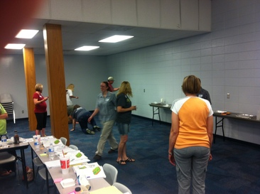 Teachers participate in a Project WET activity at the June 4th workshop in Brookfield.
The University of Missouri Bradford
Research Farm, MU Soil Health Lab, and USDA are hosting Advanced Soil Health
Trainings around the state from July 21 to August 22. Topics included in these workshops will include:
developing cover crop mixes and adjusting rotations to utilize cover crops,
integration of livestock and cover crops, rotational grazing effects on soil
health, cost to benefit ratios of management practices to improve soil health,
improving crop nutrient availability through improvement of soil health,
farming to improve organic matter and soil water retention, and soil health
testing benefits and procedures. The schedule of trainings is listed below:
July 21 – Albany, MO
July 22 – Marshall, MO
August 7 – Adrian, MO
August 8 – Lamar, MO
August 18 – Edina, MO
August 19 – Vandalia, MO
August 21 – West Plains, MO
August 22 – Owensville, MO
For more information or to get the registration form, go to http://aes.missouri.edu/bradford/events/soilhealthws.php
Attendees are asked to bring TWO
dry soil samples, 1.) one from a fence row or undisturbed native grass area and
2.) one from a field which has had a management practice applied. Basic soil tests will be conducted for these
samples.
The Grassfed Exchange national meeting
will be in Columbia, MO on July 30th-August 1st. There will be speakers and attendees from all over
the nation. Topics will include soil health, grazing, and livestock marketing.
Go to www.grassfedexchange.com for more information.
Soil Health Exposition - Rebuilding
Soils for a Changing Climate will
be at the MU Bradford Research and Extension Center on August 13-14 from 9 am
to 5 pm each day. MU Bradford Research Center is located at 4968
Rangeline Road, east of Columbia.
This
exposition is hosted by the University of Missouri and the USDA NRCS. Admission
is free, and you can come any time between 9 am to 5 pm. The two day exposition
will feature vendors, tours, demonstrations, and presentations by farmers who
have successfully incorporated cover crops into their operations. The agenda is
available at http://aes.missouri.edu/bradford/events/soilexpo.php. For more information contact Kerry Clark at
clarkk@missouri.edu or 573-884-794.
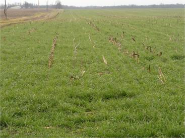 Cover crops grow after the main crop has been harvested. The cover crop provides ground cover that helps to reduce runoff and soil erosion from the field, improve water infiltration into the ground, and improve the health of soil on the field.
On June 10, 2014 the Soil and Water Districts
Commission approved to offer a pilot cover crop practice state-wide for fiscal
year 2015 which started on July 1, 2014. For fiscal year 2015, each Soil and Water
Conservation District (SWCD) will have $4,800 available to develop cost-share
contracts for the cover crop practice. Eligible
landowners or operators can receive a $30 per acre incentive payment for
implementing cover crops on a maximum of 20 acres. Landowners/operators that want to participate
in the cost-share program for cover crops will be ranked for funding based on
current field management and plans for implementing cover crops. Contact your
local SWCD office for the full details of the cover crop pilot practice
requirements and to sign up for the practice.
Missouri River Relief (Stream Team #1875) is
organizing a Big Muddy Clean Sweep this fall on the Missouri River. The
clean-up will be a two month long continuous voyage by barge to pick up trash
along the Missouri River from Brunswick to Hermann during the months of
September and October. The two month clean-up begins in Brunswick on September
6th from 9 am to noon at the Brunswick River Access. River Relief staff and volunteers will be
picking up trash along the banks of the Grand River and Missouri River around
Brunswick. To register for the event, go
to http://www.riverrelief.org/sign-up/
or you may register the day of the event at 8:30 am. If
you arrive
later than 10 a.m., it may not be possible to get you on a boat during the
morning. Volunteers will receive
a free boat ride, t-shirt, trash bags, gloves, lunch and a reusable water
bottle. Volunteers are asked to wear
work appropriate clothes, long pants to protect from weeds and poison ivy, no
open toed shoes, and bring sunscreen and bug spray. Additional Big Muddy Clean Sweep events are
being held in Boonville on September 20th, at the Capitol in
Jefferson City on October 4th, and in Hermann on October 18th. See http://www.riverrelief.org/upcoming/
for more information and for other upcoming Missouri River Relief events.
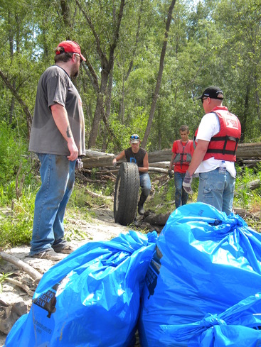 Volunteers help pick up trash at the Missouri River Relief clean-up that was held in Brunswick in May 2012. At the 2012 clean-up, 4.2 tons of trash were removed from the banks of the Missouri and Grand Rivers near Brunswick.
As a follow up from the Lower Grand River Water
Summit held in September 2013, a Regional Water Supply Workshop was held on
April 15, 2014 in Milan. Public water supply operators, water district boards,
county commissioners, and local town leaders from a ten county area in north
central Missouri were invited to attend. The workshop provided an overview of
regional water supply, an update on the East Locust Creek Reservoir project in
Sullivan County, and there were presentations and discussion about the
engineering, environmental, and legal considerations of building water
transmission lines. Attendees also
provided input about the idea of having a regional water supply transmission
network to improve the connectivity of the water systems in the region. Sixty-six
people attended the workshop, which included 44 people that represented public
water systems or local government from the ten county area. Many of the public water systems in this
watershed rely solely on water from small community lakes and local streams.
During periods of drought, there is a lack of water supply for many public
water systems in the watershed. The East Locust Creek Reservoir project is a
proposed 2,200 acre lake northeast of Milan that could potentially serve
systems in ten counties in north central Missouri.
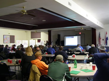 Public water supply operators and local leaders from a 10 county area met in Milan to learn about and discuss a regional water supply network for the region.
In
January of this year, residents of the Lower Grand River watershed that had
attended the Lower Grand River Water Summit in Brunswick in 2013 and attendees
of the Big River and Spring River Water Summits were invited to attend a
watershed planning workshop hosted by the University of Missouri-Extension and
the Missouri Department of Natural Resources’ 319 Program at Lake of the
Ozarks. There were about 50 people that
attended this workshop and eight attendees were representing the Lower Grand
River Watershed.
At this
workshop, attendees learned about the process of developing a nine element
watershed plan and there were presentations from groups in Missouri and other
surrounding states that have completed watershed plans and have been active in
education and other activities to reduce non-point source pollution in their
watershed. One benefit of having a nine
element plan for a watershed is that the watershed is then more competitive for
receiving 319 grants and other funding for outreach or practices to reduce
non-point source pollution.
The nine
elements of a watershed plan include 1.) identification of sources of problems
in a watershed, 2.) a description of what practices are needed to reduce the
problems, 3.) an estimate of the pollutant load reductions expected from the
practices, 4.) an estimate of the technical and financial assistance needed to
implement the practices, 5.) an information/education component, 6. ) a
schedule for implementing practices, 7.) milestones for the project, 8.)
criteria to measure progress, and 9.) a monitoring component. One of the most important parts of developing
a watershed plan is to include residents and landowners of the watershed in the
development of the plan to make sure that people living in the watershed have
the opportunity to share their ideas.
The most successful watershed plans are those in which local residents
are the leaders in outreach and activities to improve the condition of their
watershed. The Department of Natural
Resources and the University of Missouri Extension are available to assist
local groups that are interested in developing a plan for their local
watershed.
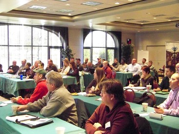 Attendees of the Lower Grand River, Big River, and Spring River Watershed Summits gathered at Lake of the Ozarks in January to learn about watershed plans, 319 grant funding for watershed projects, and outreach efforts by watershed groups in Missouri and surrounding states.
Do you
want to learn more about a certain watershed or stream? There are several internet tools that provide information
to learn about your watershed. The first
is called the Missouri Watershed Tool and is available at http://ims.missouri.edu/website/watershedTool/. This
website is managed by the Center for Applied Research and Environmental Systems
(CARES) through the University of Missouri-Columbia and was partially funded
through a 319 grant. At this website,
you can find information for any HUC 8, HUC 10, or HUC 12 watershed in the
state of Missouri. A HUC (or Hydrologic Unit Code) is a code that is used to
identify a certain drainage basin, similar to a zip code for a particular
geographic area. HUC 8 watersheds are
the largest in size and within a HUC 8 watershed, there are smaller HUC 10
watersheds, which are then composed of smaller HUC 12 watersheds. HUC 12 drainage basins are typically about
10,000 to 40,000 acres in size (See the Spring 2013 Lower Grand Newsletter for
more explanation of Hydrologic Unit Codes (HUCs)). At the Missouri Watershed Tool website, you
can search by county to find the HUC 8’s, HUC 10’s, and HUC 12’s that overlap
that county. Then, when you select a certain HUC, a summary is available that
provides information about the population demographics, streams, land use and
characteristics, and water monitoring in that drainage basin. Data found on this website has been gathered
from data ranging from 2004 to 2012, so this website is a good place to start
learning about general characteristics of your watershed, although some of the
data may have changed slightly since the website was last updated.
The
EPA’s Surf Your Watershed website at http://cfpub.epa.gov/surf/locate/index.cfm can also be used to gather information about
a watershed. At this website, you can
search by zip code, city, watershed name, county, stream, or 8 digit HUC number
to find a HUC 8 watershed in your area. Once
a search is completed for a specific area, information for the HUC 8 watersheds
in that area is provided, including a map of the watershed and information
about water quality data, impaired streams, USGS stream flow gages, and citizen
groups in the watershed. Another
watershed tool is the “How’s My Waterway” website also provided by the EPA at http://www.epa.gov/mywaterway. At
this website, you can search by zip code or city to find which waterways in
your area have been assessed for water quality and if the waterbody met water
quality standards or if it is considered impaired.
This
catalog of federal funding sources is available at www.epa.gov/watershedfunding. On this website, you can search for funding sources for your project.
You can query funding sources by your type of organization, your type of
project, whether the funding is a grant or loan, whether match is required or
not, and what agency the funding is through. For example, I conducted a search
as a community/watershed group, and I asked to see all funding opportunities
related to a project related to Best Management Practices (BMPs). My search
resulted in 16 programs through 7 different federal agencies that may be able
to provide funding for BMPs, depending on what type of BMP is desired for a
project.
If
you have an idea for a project in your community or watershed, your local
watershed coordinator can assist you in searching for a funding source to fit
your project.
The
overall goal of the Our Missouri Waters effort is to identify issues in a
watershed, engage local watershed communities to help identify priorities and
solutions to water issues, and better target and prioritize funding and
resources within a watershed. There is a great video
about the purpose of the Our Missouri Waters effort on the website at http://dnr.mo.gov/omwi.htm. If you have not seen this video yet, check it out!
Are you interested in
providing input about the department’s watershed effort? Do you have an idea for
a water quality project in the watershed? Does your community or school need
financial assistance for a project? Are you interested in water education? Do
you want to form a Stream Team or join an existing Stream Team? Do you have
ideas that could benefit the communities and resources of this watershed? Do you
have questions about the watershed or about the Our Missouri Waters effort? If
you have any ideas, comments, questions or suggestions, please give me a call
or send me an email. I can be reached at 660-385-8000 or at Mary.Culler@dnr.mo.gov.
This newsletter, along with
our previous newsletters will be posted on the Our Missouri Waters website at http://dnr.mo.gov/omwi/lowergrand.htm.
 Celebrating 40 years of taking care of Missouri's natural resources. To learn more visit dnr.mo.gov. |