|
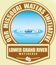
As part of the kick-off for the Our Missouri Waters effort, watershed summits were held in each of the three pilot watersheds during 2013. The Spring River Water Summit was held in Joplin on May 29-31 and the Big River Summit was held in Park Hills on October 9th. The Lower Grand River Water Summit “Meet at the Mouth of the Grand” was held at the Knight and Rucker Hall in Brunswick, MO on September 10th. There were 115 attendees of the Lower Grand Water Summit, which included 68 residents of counties of the Lower Grand watershed. The event was co-hosted by the Green Hills Regional Planning Commission and the Missouri Department of Natural Resources. The Summit was planned by a committee of 14 individuals from local, state, and federal organizations, including the Missouri Department of Natural Resources, Green Hills Regional Planning Commission, Missouri Department of Economic Development, USDA Rural Development, Missouri Rural Water Association, Missouri Public Utility Alliance, North Central Missouri Regional Water Commission, University of Missouri Extension, and MFA AgriServices of Brunswick.
Mayor Jerry Calvert welcomes attendees to Brunswick for the Lower Grand Water Summit.
The Summit was open to all, however the event was specifically promoted for community leaders and drinking water and wastewater operators in the watershed. Nearly 300 contacts were sent invitations, including county commissioners, town governments, certified drinking water and wastewater system operators, public water systems, area Chamber of Commerce, Soil and Water District Board members, and MU-Extension from the watershed. A survey was sent to this group in March 2013 to find out what topics these groups would be interested in hearing about at the Summit and to receive input about expected outcomes of the meeting. Based on the results of these surveys, three main topics were discussed at the Summit including 1.) Water Supply, 2.) Watershed Management (landscape and stream modifications that affect flooding and runoff), and 3.) Community Infrastructure and Grants and Loans.
Missouri Department of Natural Resources Director, Sara Parker Pauley, and Executive Director of the Green Hills Regional Planning Commission, Randy Railsback, both gave keynote addresses at the Summit. There were then presentations and group discussion periods about the three main topics. Sixteen exhibitors also hosted booths at the summit, which provided information to attendees about activity occurring within the watershed and resources available to their communities. Breakfast and lunch were both catered by Sherry’s Home Cooking in Brunswick, and both meals were delicious. The Brunswick Area Chamber of Commerce also provided welcome packets to attendees that included locally grown pecans. After lunch, there was a rainfall simulation demonstration that showed the volume of water and soil runoff from different land management practices (see article below about Doug Peterson’s demonstration video). During the Summit, Turning Point software (voting) was also used to gather responses from the audience about a variety of questions.
After the indoor portion of the Summit had completed, there were two optional tours which included a demonstration by Lakes of Missouri Volunteer Program coordinator, Tony Thorpe, at the Brunswick Missouri River Access and a tour of the Missouri River barge terminal at MFA AgriServices of Brunswick by General Manager, Bill Jackson. Operator certification training hours were approved for the Summit, including 3.5 Wastewater hours, 3.0 Drinking Water Treatment hours, and 3.0 Drinking Water Distribution hours.
Results from Turning Point voting at the Summit showed that 100 percent of local attendees agreed that the Summit was a useful event for them to attend. A follow-up survey was also sent out after the Summit to the 68 local attendees to receive feedback about the various parts of the Summit and to receive overall comments about the Summit. 100 percent of respondents from this survey said that they would recommend attending a water summit to others. Comments received from the pre-Summit survey, the group discussion periods during the Summit, and the post-Summit survey will be used to determine future actions and “next steps” in involving local watershed residents to help prioritize, plan, and develop solutions for water resource issues in the Lower Grand.
If you were not able to attend the Summit but are interested in the event, there are videos and Power Points of the Summit presentations on the Our Missouri Waters Lower Grand River watershed website at http://dnr.mo.gov/omwi/lowergrand.htm.
Many thanks to the City of Brunswick, Brunswick Area Chamber of Commerce, MFA AgriServices of Brunswick, and Knight and Rucker Hall for their assistance in hosting the 2013 Lower Grand River Water Summit.
New Grant now Available for Wastewater Engineering Assistance for Small Communities
A new grant opportunity has recently become available through the Department of Natural Resources for small communities that need engineering assistance for wastewater system plans. The program is called the Small Community Engineering Assistance Program. It is available to municipalities, counties, public sewer or water districts, political subdivisions or instrumentalities of the state with a population of less than 10,000 people.
The program offers funding for wastewater engineering costs incurred in preparation of a facility plan. The funding is only available for recipients yet to achieve a funding commitment and who plan to pursue funding.
Communities may be eligible to receive an 80 percent grant with a 20 percent recipient match, while disadvantaged communities may be eligible to receive a 90 percent grant with a 10 percent recipient match. A disadvantaged community is defined as any community with a population of 3,300 or less, whose user rates will be at or above 2 percent of the median household income and the median household income is at or below 75 percent of the state average.
The grant amount shall not exceed $50,000. Applications are accepted at any time. For more information, or to learn how to apply for this grant, contact the Missouri Department of Natural Resources Financial Assistance Center at 573-751-1192.
Five Star Grants deadline February 5, 2014.
The National Fish and Wildlife Foundation Five Star Grant program is open for applications. Most grants awarded will be in the range of $20,000 to $50,000, and the average award is $25,000. The grant requires a 1:1 match, which can be in-kind services. The grant also requires that you have several partnering groups (such as local government, businesses, non-profit groups, state, and federal agencies) involved in the project. This program is looking for on-the-ground wetland or stream restoration, an educational component, and must have measurable benefits to the ecosystem and community. For more information, go to http://www.nfwf.org/fivestar/Pages/home.aspx or give your regional watershed coordinator, Mary Culler, a call at 660-385-8000 if you have a project idea that you might like to apply for with the Five Star Grants program.
Local Producer Kenny Reichert was awarded with the Olin Sims Conservation Leadership Award for Conservation Work in Chariton County
Kenny Reichert, who owns and operates his family’s farm in Chariton County, was awarded the Olin Sims Conservation Leadership Award in 2013. The Olin Sims Conservation Leadership Award recognizes an individual who provides superior service to the conservation community in promoting and leading conservation on private lands.
Kenny Reichert is chairman of the Chariton County Soil and Water Conservation District Board. Reichert was recognized with this award for his work to promote soil health in Chariton County and also his work to promote conservation practices through the Mississippi River Basin Healthy Watersheds Initiative (MRBI). Reichert has helped lead soil health initiatives in the county which have included two cover crop workshops, the development of a cover crop research farm, and a pilot cover crop cost-share practice in the county.
On his own farm, Kenny has done no-till farming for almost 30 years. Over the last 3 years, he has been working cover crops into his operation and has now worked up to using cover crops on 230 acres. Kenny has planted a variety of cover crop species, including rye, hairy vetch, wheat, winter peas, radishes, and several others. This year, he also grazed his cattle on cover crops, which worked well for his operation. During his second year of using cover crops, Kenny was able to cut back on herbicide application on his soybean field where cover crops had been used. Kenny is already beginning to see the benefit of using cover crops to improve soil health on his farm. “It is hard to put a value on soil heath”, Reichert said. In addition to cover crops, Kenny has used terraces, grass waterways, and nutrient management on his farm to reduce soil erosion and improve water quality.
The late Olin Sims was a Wyoming rancher and National Association of Conservation Districts president whose life was distinguished by years of volunteerism to conservation. Jason Weller, acting chief of the USDA’s Natural Resources Conservation Service (NRCS) presented the award to Kenny on January 29, 2013 at the National Association of Conservation Districts annual conference in San Antonio, Texas.
Do you know a local farmer in the Lower Grand River Watershed that is doing great conservation work on their farm? We would like to recognize other producers in future newsletters. Please send your suggestions to Mary.Culler@dnr.mo.gov or call Mary at 660-385-8000.
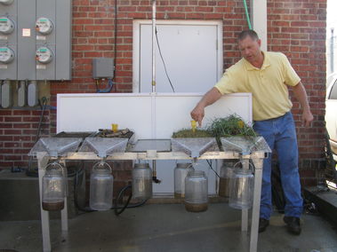 Doug Peterson, State Soil Health Conservationist with NRCS, demonstrates the amount of runoff and erosion that occurs after a 1 inch rainfall.
At the Lower Grand River Water Summit on September 10th in Brunswick, Doug Peterson, the State Soil Health Conservationist for the Missouri Natural Resource Conservation Service (NRCS) gave a great demonstration that showed how tillage practices and vegetation cover have a huge impact on the amount of water that runs off of our landscape. Doug had also presented this demonstration at the State Soil and Water Commission meeting in Chariton County last April. If you have not yet seen Doug’s demonstration, you can watch this video at http://www.youtube.com/watch?v=AZPkeg9s4DI. This link is also available on the Missouri Soil and Water Program’s homepage at http://dnr.mo.gov/env/swcp/index.html.
This demonstration shows how five different land management types (tall pasture, short pasture, conventionally tilled row crop, tillage with cover crop, and no till with cover crop) affect the amount of rain that soaks into the ground during a one inch rainfall. During the rain simulation, water that soaks into the ground for each land management type is collected in a container that is placed beneath the soil to show the amount of water that soaks in (infiltrates) the soil. Water that does not soak in is allowed to runoff and this water is collected in a separate container for each management type. The demonstration shows that more water runs off of short pasture when compared to tall pasture, and more water runs off of tilled soil when compared to no-till soil. In fact, there was very little (if any) water that ran off of the no-tilled soil with cover crop.
When it floods in an area, there are many factors that affect the volume of runoff and the severity of flooding. I grew up in Springfield, Missouri, which at times had severe urban flooding issues. I remember several times when a stream flowed across the grass in our backyard after a heavy rainfall and we had to put boards up in front of our garage to prevent water from rushing in, even though there were no creeks normally running through or remotely near our property. If we had a particularly heavy storm and conditions were just right, we were even “lucky” enough to have a “rain day” instead of a “snow day” because our elementary school flooded. Although my brother and I enjoyed the day off from school and it gave us a chance to go outside and play on our new waterfront property, these “flash floods” resulted in property damage and costs to our community. In the urban setting, the impervious pavement of roads and parking lots, and the short grass found on residential and commercial lots, no doubt played a role in reducing the amount of rainfall that soaked into the ground. With less rain soaking into the ground, more water was available on the surface leading to greater flooding.
Doug’s demonstration shows that how our soil is managed in an agricultural setting can have some of the same effects on runoff and infiltration rates that we see in urban areas due to pavement and short lawns. Take the time to watch this video. You may find yourself telling others about it, too.
Do you have a favorite fishing spot in the Lower Grand River Watershed where the catch depends on having just the right water level in the river? Are you thinking about canoeing or boating on a river but are not sure if the water is too high or too low to go? Do you have to change your route to work when there is flooding in your area? Or, are you interested in how high or how low a river is this year compared to a “normal” year? Real time data for several streams in the Lower Grand River Watershed are available on the United States Geological Survey’s website.
Streams in the Lower Grand that have gage stations include the Little East Locust Creek near Browning, Locust Creek near Linneus, the Grand River at Chillicothe, Medicine Creek at Lucerne, Medicine Creek near Laredo, Muddy Creek near Chula, the Grand River near Sumner, and Hickory Branch near Mendon. Gages on these streams read the stream discharge (cubic feet per second) and/or gage height every 15 minutes. Data is then transmitted and available on the USGS website. Check out these gage sites to see “real time” data for the streams in your watershed:
USGS 06901250 Little East Locust Creek near Browning, MO
USGS 06901500 Locust Creek near Linneus, MO
USGS 06899680 Grand River at Chillicothe, MO
USGS 06899900 Medicine Creek at Lucerne, MO
USGS 06900050 Medicine Creek near Laredo, MO
USGS 06900640 Muddy Creek near Chula, MO
USGS 06902000 Grand River near Sumner, MO
USGS 06902100 Grand River below Sumner, MO (auxiliary gage)
USGS 06902995 Hickory Branch near Mendon, MO
When the Lewis and Clark expedition traveled up the Missouri River in 1804 and neared the mouth of the Grand River near Brunswick, Captain Meriweather Lewis wrote “Where the Grand River enters: just above a beautiful and extensive prairie…..about the entrance of this river the lands are extremely fertile: consisting of a happy mixture of prairies and groves, exhibiting one of the most beautiful and picturesque scenes that I ever beheld.”
At the time of the Lewis and Clark expedition in 1804, the Native American Missouri and Osage tribes inhabited the Lower Grand region. During the 1700s until the Louisiana Purchase in 1803, the region was under French control. The landscape of the Lower Grand basin was historically a diverse mix of prairie, savanna, and forest plant communities with numerous small oxbows and bottomland lakes and sloughs. European settlement of the region occurred in the mid 1800s. Early European settlers were limited in their attempts to farm crops because their farming equipment could not plow or break the dense clay soils of the region. Railroads were built in the region in the 1870s and 1880s. In the 1880s farming equipment had improved that allowed for plowing of the clay soils, and there was increased settlement in the region as prairie was converted to agriculture land.
In the late 1800s and early 1900s, channelization and drainage projects began in the Lower Grand Basin to try to control flooding and to allow floodplains to be used for growing crops. Channelization of many of the major streams in the Lower Grand Basin (Locust Creek, Medicine Creek) occurred during the early 1900s. Levee systems were also constructed during the early 1900s by organized levee districts. The Garden of Eden Levee near the confluence of Yellow Creek and the Grand River was completed in 1926. Private levee construction also occurred throughout the watershed in the 1970s and 1980s.
In 1937, Swan Creek National Wildlife Refuge was established by President Franklin D. Roosevelt, and Pershing State Park was established the same year. Fountain Grove Conservation Area was established in 1947 and 1948.
Today, agriculturally based communities are the heart of the Lower Grand Basin. As farm sizes have increased over the years and new agriculture practices and equipment require fewer people to farm more acres, the population of counties and some communities have started to decline. Availability of abundant, good quality water has been and will continue to be critically important for the success of the farms, communities, and industries in the Lower Grand Basin.
Your local Soil and Water Conservation District offers cost-share on many different practices that prevent or control soil erosion and nutrient runoff as well as protecting water quality. Here are a few practices that could be very beneficial to your farm both economically and environmentally. Cost-share helps pay a portion (up to 75 percent) of the landowner’s costs to help landowners implement practices that they want to do on their land, but may not be able to afford.
WQ10 – Stream Protection
This conservation practice helps you keep livestock safe and improve water quality by fencing out streams, and provides an alternate drinking water source for your livestock.
- Applies to areas immediately adjacent to permanent, losing (streams that lose water underground), or intermittent (seasonal flow) streams that have a defined stream bed where livestock have uncontrolled access for watering purposes.
- Landowners can receive an out-of-production incentive payment of $500 per acre for the buffer area between the stream and the fence (contact the office for distance minimum and maximums).
- Landowners can receive cost-share assistance up to 75 percent of the state average cost on livestock exclusion fence, stream crossings, water distribution and tank(s).
- Up to $3,500 cost-share assistance for development of a pond or a well if a watering source is not available.
N391 – Riparian Forest Buffer
This conservation practice helps you improve water quality by creating a buffer area by planting trees along a stream or other water sources.
- Applies to areas adjacent to permanent or intermittent streams, public drinking water reservoirs and natural wetlands.
- Reduces pesticide drift and nutrient runoff from entering the water body.
- Landowners can receive an out-of-production incentive payment of $1,200 per acre.
- Planting trees is required in the buffer area.
- Fencing is required only if livestock have access to the buffer area.
- Landowners can receive cost-share assistance up to 75 percent of the state average cost on exclusion fence (if necessary for livestock exclusion), tree planting, and limited access watering point for livestock.
- Up to $3,500 cost-share assistance for development of pond or a well when livestock are excluded and if a watering source is not available.
N472 – Livestock Exclusion
This conservation practice helps keep livestock safe and protect water quality in areas such as woodlands and wetlands by fencing out livestock.
- Applies to existing ponds, woodlands, sinkholes, streams or sensitive areas where vegetation, soil condition, and water quality are in need of protection from livestock.
- Landowners can receive cost-share assistance up to 75 percent of the state average cost for exclusion fence.
If you have any questions about these or other conservation practices, contact your local Soil and Water Conservation District office.
The overall goal of the Our Missouri Waters effort is to identify water resource (quantity and quality) issues in a watershed, engage local watershed communities to help identify priorities and solutions to water resource issues, and better target and prioritize funding and resources within a watershed. There is a great video about the purpose of the Our Missouri Waters effort on the website at http://dnr.mo.gov/omwi.htm. If you have not seen this video yet, check it out!
Are you interested in providing input about the department’s watershed effort? Do you have an idea for a water quality project in the watershed? Does your community or school need financial assistance for a project? Are you interested in water education? Do you want to form a Stream Team or join an existing Stream Team? Do you have ideas that could benefit the communities and resources of this watershed? Do you have questions about the watershed or about the Our Missouri Waters effort? If you have any ideas, comments, questions or suggestions, please give me a call or send me an email. I can be reached at 660-385-8000 or at Mary.Culler@dnr.mo.gov.
This newsletter, along with our previous newsletter will be posted on the Our Missouri Waters website at http://dnr.mo.gov/omwi/lowergrand.htm. |