|
August 2014
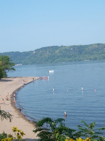 As part of recent changes to water quality standards, the Minnesota Pollution Control Agency (MPCA) Citizens Board adopted a site specific standard for Lake Pepin designed to reduce several algal blooms.
Based on research, the site specific standard for Lake Pepin consists of:
- 100 micrograms per liter for total phosphorus; and
- 28 micrograms per liter for chlorophyll-a.
The MPCA believes these criteria will provide protection of aquatic recreational uses for Lake Pepin and the downstream Mississippi River pools, and should be applicable over the range of flows for which the criteria were developed.
For perspective, the mean level of total phosphorus in Lake Pepin from 2000-2009 was 171 micrograms per liter. Reductions in phosphorus loads from wastewater over this same period resulted in Mississippi River concentrations approaching 150 micrograms per liter in 2009. The mean level of chlorophyll-a from 2000-2009 was 30 micrograms per liter.
Achieving this standard for Lake Pepin will mean reducing phosphorus and chlorophyll in specific upstream watersheds, such as the Lower Minnesota River, Crow River and Sauk River. To quote the Executive Summary of the criteria document, "The proposed Lake Pepin criteria should not be used in isolation to imply that phosphorus reductions anywhere upstream of the lake will have the desired impact. The main biological activity affecting Lake Pepin trophic status is not taking place in the lake, but upstream of it." In particular, reductions upstream of the Minneapolis-St. Paul wastewater treatment plants will be needed to achieve the desired standards.
The board also adopted changes that address eutrophication of rivers, streams and Mississippi River navigation pools. In addition, the amendments replace the turbidity standard with a Total Suspended Solids standard.
A draft of the amendments was released in June 2013, followed by a public comment period from November 2013 to January 2014, including a public hearing held Jan. 8, 2014. Seventeen parties commented on the amendments. See their comments, the MPCA responses and more details in the board packet online.
The MPCA Citizens Board adopted the standards at its June 24, 2014 meeting.
Following that meeting, the Minnesota Environmental Science and Economic Review Board petitioned the MPCA Citizens Board for a stay and reconsideration of the standards. At its July 22 meeting, the board heard from several parties about the petition before voting to deny the stay. A webcast of the meeting, along with the board packet, is available on the agency website.
|
A series of public meetings are scheduled in September to hear about and discuss the June 19 Minnesota River Congress, leading up to a second congress scheduled for Oct. 30 in New Ulm.
Congress organizers believe there’s a need for greater unity and communication among the many groups working to sustain the water and land in the Minnesota River Valley for agriculture and the overall economy.
At the June 19 congress about 100 people shared a meal, and gathered in small groups to discuss ideas for the future of collaborative efforts to protect and improve land and water resources in the Minnesota River basin. Information and display tables set up by more than 20 organizations contributed greatly to the networking action.
Regional meetings are planned for 7 p.m. at the following dates and hosts. Everyone is welcome to attend.
- Sept. 10, Clean Up the River Environment, Community Center, 550 1st St. SW, Montevideo.
- Sept. 11, Rural Advantage, Knights of Columbus Hall, 920 E. 10th St., Fairmont.
- Sept. 15, J.R. Brown Heritage Society, Henderson Community Center, Henderson.
- Sept. 16, Friends of the Minnesota Valley, National Wildlife Refuge, Bloomington.
- Sept. 17, Lower Sioux Community, Jackpot Junction, Morton.
"Working together to protect and improve natural resources promises a better future for food production, recreation, and economic development," says Scott Sparlin, of the Coalition for a Clean Minnesota River. "We need ideas and support from all across the basin to realize the potential for funding and influence that we need to make a real difference in the Minnesota River Valley."
The June 19 congress generated a wide range of ideas. Many expressed support for citizen participation and leadership, either at the basin scale or starting out first at the watershed scale – the basin consists of 13 separate watersheds. Since the disbanding of the Minnesota River Board earlier this year, the need for collaboration and communication among groups working the basin ranked high.
"There was a lot of discussion and support for a citizen-led, all-inclusive organization, but less agreement about the possible structure," Sparlin said. "The regional meetings will give more people the chance to help us focus the ideas leading up to the second congress on Oct. 30."
Congress co-sponsors include: Minnesota River Watershed Alliance, Coalition for a Clean Minnesota River, Friends of the Minnesota Valley, Minnesota Agricultural Water Resource Center, Water Resource Center-Minnesota State University, Clean Up our River Environment, Minnesota Dept. of Natural Resources, Minnesota Pollution Control Agency, Minnesota Earth Sabbath, Clean Up the River Environment, Wild River Academy, New Ulm Area Sport Fishermen, and the U of M Southwest/Southeast Regional Sustainable Development Partnerships.
For more information contact Sparlin at 507-276-2280, yasure@lycos.com. A summary of the June 19 congress is posted on the Minnesota River Watershed Alliance webpage.
A University of Minnesota study has found that the conversion of grassland to cropland in southeast Minnesota is a threat to private drinking water wells and could lead to costly fixes for nitrate contamination.
The study was recently published in Environmental Research Letters. According to the abstract:
"We find that conversion of grassland to agriculture from 2007 to 2012 in Southeastern Minnesota is expected to increase the future number of wells exceeding 10 parts per million nitrate-nitrogen by 45 percent (from 888 to 1,292 wells). We link outputs of the groundwater well contamination model to cost estimates for well remediation, well replacement, and avoidance behaviors to estimate the potential economic value lost due to nitrate contamination from observed land-use change. We estimate $0.7–12 million in costs (present values over a 20-year horizon) to address the increased risk of nitrate contamination of private wells."
Minnesota Public Radio also reported on the study: "Crop switch could cost millions in water contamination."
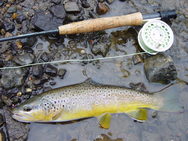 Many streams flowing to Lake Pepin in southeast Minnesota offer high water quality and need protection, while a handful of trout streams need reductions in bacteria levels, according to a study by local partners and the MPCA.
The study is open for public review and comment through Sept. 10.
Called a Watershed Restoration and Protection Strategy, the study summarizes the health of a watershed. It also includes a report on Total Maximum Daily Loads, which are the maximum amounts of pollutants that streams can receive and still meet water quality standards.
This study focuses on the Mississippi River-Lake Pepin watershed from Red Wing to Lake City. This area encompasses 205,747 acres that drain several small coldwater streams in southeast Minnesota. (This study excludes Lake Pepin, which is the focus of a separate project.) The land is diverse with forests, bluff lands and cropland. Many streams here are popular for trout fishing.
For the most part, the streams are in good condition, supporting a healthy community of fish and macroinvertebrates. Macroinvertebrates are creatures without backbones, such as insects, snails and small clams, and are commonly called bugs. By examining a stream’s biological health, scientists can gauge the health of water resources. The healthier the water, the more diverse the fish and bug populations.
The study did identify a few concerns. The levels of bacteria in the following streams violate the state standard – Hay, Bullard, Gilbert, Miller and Wells creeks. The bacteria come from manure applied to cropland, rain and snowmelt runoff, and failing sewer systems.
Another concern is the level of nitrogen in some waters. Nitrogen can make water harmful for humans and aquatic life. While none of the trout streams violates the standard of 10 parts per million (ppm) of nitrate, concentrations range from 2-8 ppm. Extensive research in Minnesota and other states has found that human impacts are the main reason for higher nitrogen levels in lakes and streams. In this watershed, manure and fertilizer leaching from cropland are likely the main sources of nitrogen in streams. One study of southeast Minnesota trout streams found that the higher the percentage of row crops in the surrounding watershed, the higher the nitrogen concentrations.
Although nutrient and sediment levels in these streams are low enough for the streams to still meet standards, the pollutants do impact downstream waters, from Lake Pepin all the way to the Gulf of Mexico. Because of that, the study recommends several strategies to protect the streams in southeastern Minnesota and downstream waters.
The study report summarizes work in the watershed dating back several years, including intensive water monitoring, sampling fish and bugs at 21 sites, and identifying conditions stressing the health of streams. It recommends the following:
- Managing fertilizer and manure applications to reduce impacts to waters;
- Expanding cover crops to help keep soil in place and enhance soil health;
- Holding back runoff to prevent flooding and erosion while letting pollutants settle out;
- Improving habitat;
- Restoring streams and their banks;
- Upgrading or replacing sewer systems;
- Complying with the Goodhue County mining ordinance that prohibits the use of certain additives for processing silica sand and requires setbacks from streams and other resources; and
- Continued monitoring to detect changes in pollutant levels and watershed conditions.
Local partners played a key role in the watershed study and will play a leading role in protecting the waters: Goodhue and Wabasha counties and their Soil and Water Conservation Districts; cities of Red Wing and Lake City; and Wells Creek Watershed Partnership.
For more information on the study or to submit written comments, contact Justin Watkins, MPCA project manager, at justin.watkins@state.mn.us or 507-206-2621. The study is available on the Mississippi River – Lake Pepin project webpage.
|
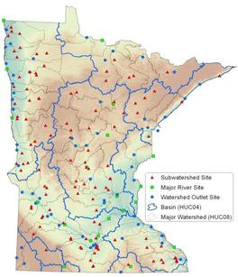 The Minnesota River basin is a priority area for sampling grants through Watershed Pollutant Load Monitoring Network. Grants under this program are financed through the Minnesota Clean Water Fund established by the Legacy Amendment. The MPCA will award up to $300,000 in one-year grant contracts through a competitive process. All proposals must be submitted through the SWIFT e-supplier portal and must be received no later than Sept. 19, 2014. Proposals received after this deadline will not be considered.
The primary objective of the monitoring network is to obtain spatial and long-term pollutant load information from Minnesota’s rivers and streams (map at right shows monitoring locations). This RFP seeks local partners to collect water quality data at select sites in the Minnesota River and Upper Mississippi River basins. Water quality samples will be collected across a full range of flow conditions with greatest emphasis given to periods of moderate and high flow. Water quality data will be paired with stream flow information to yield estimates of contaminant loading from within a watershed.
Eligible entities include:
- Soil and water conservation districts;
- Watershed districts;
- Regional planning organizations;
- Watershed management organizations;
- Local government units such as counties, cities, townships and lake improvement districts;
- Regional governmental groups;
- Joint powers boards;
- Minnesota colleges and universities;
- Nonprofit organizations; and
- Native American tribal governments.
Applicants must have a SWIFT Vendor ID and Supplier Portal Account to access the RFP and apply for the WPLMN Sampling Grant. Detailed registration directions are available on the SWIFT e-supplier portal. Proposers should be aware that it can take several days to receive a required Vendor ID from SWIFT. If you need technical assistance for the SWIFT e-supplier portal, please contact the SWIFT helpdesk line: 651-201-8100, option 1.
Grant recipients will be notified and required to submit a detailed work plan and budget. Please note that the successful execution of these grants by the start of the monitoring season is dependent on adhering to this process and timeline. Additionally, grant recipients will be required to use SWIFT to review and approve, through electronic signature, the final contract and work plan.
Additional information can be found at the MPCA’s WPLMN webpage.
|
The 43rd Annual Crop Production Field Day hosted by the University of Minnesota Extension will be Thursday, Sept. 4, at Keith and Jay Kuiters' farm, one-fourth mile south of Clarks Grove on Freeborn County Highway 45.
Registration begins at 9:30 am and the program starts at 10 am. Lunch will follow.
Speakers and topics are as follows:
- Dan Kaiser, U-M Extension nutrient management specialist: What's New with Drones and Nutrient Management
- David Pfarr, DuPont Pioneer strategic account manager: Cropping Budgets in the Context of 2014-15 Commodity Prices
- Brad Carlson, U-M Extension educator: Nitrates in Drainage Water
- Ryan Miller, U-M Extension educator: Building Competitive Advantage with Integrated Pest Management
- Barry Kurtz, Riverland FBM instructor: 2014 Farm Business Management Update
The event is free and open to the public. For more information, call 507-536-6310 or 888-241-4536.
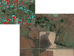 Helping decision makers prioritize where to restore and protect wetlands is the purpose of a new online tool. The tool helps maximize water quality benefits and funding by:
- Predicting likely locations of restorable wetlands with a statewide restorable wetland inventory.
- Locating highly stressed areas most in need of water quality or habitat improvement.
- Prioritizing areas that have the potential to be, or currently are, high functioning sustainable wetlands.
- Identifying areas with the greatest benefits in the form of water quality and habitat.
- Refining prioritizations with aerial imagery and available environmental data.
Called the Restorable Wetland Prioritization Tool, it builds on and incorporates previous targeting approaches including the Environmental Benefits Index (EBI) and Stream Power Index (SPI) to produce three primary decision layers:
- Environmental STRESS;
- Expected BENEFITS; and
- Expected restoration success or VIABILITY layer.
The Restorable Wetland Prioritization Tool allows users to adjust the weight of the three decision layers to select the best regional restoration locations to meet watershed challenges and goals. Each primary decision layer can be focused on water quality nutrient reduction, either phosphorus or nitrogen, or habitat emphasis. All data layers are offered as statewide coverage, including the restorable wetland inventory layer as well as many supporting physical or landscape information layers.
Most users will be able to complete their strategic wetland restoration project inquiries entirely within the online tool application. However, several of the derived decision layers, including unique blends of data layers, can be exported as raster image files which can then be added to standard desktop GIS projects.
Please note that full tool functionality is available using Firefox, Safari or Google Chrome internet browsers. Internet Explorer does not fully support the tool functionality.
The Natural Resources Research Institute (NRRI) at the University of Minnesota-Duluth developed this tool and continues to host it online at www.mnwetlandrestore.org. Funding support to develop this tool was possible through the Clean Water Legacy Amendment through a contract between the MPCA and NRRI. The NRRI's mission is to foster the economic development of Minnesota's natural resources in an environmentally sound manner to promote private sector employment.
For more information contact Mark Gernes of the MPCA south biological monitoring unit at mark.gernes@state.mn.us or 651 757-2387.
|
|