|
Issue 8 | Late Fall 2014
Project obtains 85 percent local funding commitments
Southwest LRT ends year with strong vote of confidence from 2 local funders
The Southwest LRT Project (METRO Green Line Extension) is well positioned to seek the federal 50 percent match in 2016 to build the $1.65 billion line.
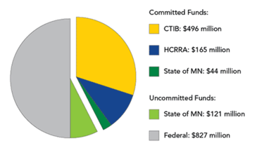
The Counties Transit Improvement Board (CTIB) and Hennepin County Regional Railroad Authority (HCRRA) earlier this fall approved their full commitments of $496 million (30 percent) and $165 million (10 percent), respectively. The state has committed $44 million of its $165 million (10 percent) share.
With $705 million in local funding committed, the project has an 85 percent local funding commitment, which is more than the 70 percent that the Federal Transit Administration requires before approving projects to enter into the Engineering phase. The project expects to receive FTA approval in 2015 to enter into Engineering and a Full Funding Grant Agreement from the FTA in 2016 for $827 million (50 percent) in matching funds. |
|
 |
“The commitments show that our local funding partners recognize the project’s strength following resolution of some big issues through the municipal consent process. The actions by the transit board and regional railroad authority are an important seal of approval that the FTA wanted to see,” said Chair Sue Haigh of the Metropolitan Council.
City, park board to help select Kenilworth landscape designer
Consultant to design Kenilworth Corridor landscape elements for Southwest LRT
The Southwest LRT Project is in the process of hiring a design consultant firm or team, including a landscape architect and architect, to design the landscape elements in the Kenilworth Corridor area.
It is part of this summer’s agreement between the Metropolitan Council and city of Minneapolis, which says the Met Council will select a landscape architect to design the Kenilworth Corridor to maintain the “park-like” setting. The city and Minneapolis Park & Recreation Board will serve on the consultant evaluation panel. The general public can get involved in the spring.
The project will:
- Facilitate a transparent and inclusive design process that includes the city, Minneapolis Park & Recreation Board, Hennepin County Regional Railroad Authority, surrounding neighborhoods and trail users;
- Develop designs that support the Kenilworth Corridor area as a park-like setting so that the corridor continues to be a regional asset as it connects to the Minneapolis Chain of Lakes;
- Generate a design that integrates and visually minimizes LRT-related infrastructure in the Kenilworth Corridor area for corridor users and from the adjacent park system and neighborhoods.
Design work to begin in early 2015
Southwest Project Office staff met in September 2014 with staff from the city of Minneapolis, park board and Hennepin County to review and receive input on the scope of work for the Kenilworth landscape design consultant. The project office advertised a Request for Proposals in October 2014 and anticipates issuing a Notice to Proceed to the selected consultant in February 2015. Technical staff representing the city, park board, county and project office will be on the evaluation panel to select the consultant.
The consultant’s work will occur concurrently with the work of the advanced design consultant. Once the Kenilworth landscape design consultant’s work is 60 percent complete, the work will be further developed by the advanced design consultant who will advance the designs into full construction bid documents concurrent with the design of the Southwest LRT Project. The Kenilworth landscape design consultant shall review and comment on progress plans from 60 to 100 percent completion, provide design support through construction and be available for ongoing support related to design work to ensure that the design of the Kenilworth Corridor area is realized.
 |
|
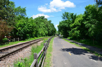
Left: Trails and freight rail tracks run side by side through the Kenilworth Corridor. The Southwest LRT line would run in a shallow tunnel under this area near West 29th Street. |
Public will be involved with the Kenilworth landscape design
In spring 2015, the Southwest Project Office will form an advisory committee and ask the community to participate in a series of public workshops to help shape the future vision of the corridor. From that, the Kenilworth landscape design consultant will develop conceptual designs. The project office will then ask the community to review conceptual designs and provide feedback. The Kenilworth landscape design consultant will again use the community feedback to advance the design, and the project office will invite the community to review and provide feedback in summer 2015. This multi-step community participation is intended to be hands on, as the workshop format provides direct engagement opportunities.
Southwest Project Office staff will provide periodic updates throughout this process to the project’s advisory committees: Corridor Management Committee, Business Advisory Committee and Community Advisory Committee.
Scope of Kenilworth design consultant’s work includes environment, aesthetics
The design consultant’s scope of work will be design of the Kenilworth Corridor area’s environment and aesthetics. This includes:
- Landscape elements
- Re-establishment of the trail system
- Access and other urban design elements between West Lake Station to just east of Penn Station (on property owned by Hennepin County Regional Railroad Authority)
- Public engagement and collaboration with multiple project partners
Design starting point will be analysis of existing landscape, ped/bike patterns
The Kenilworth landscape design consultant’s work will start with a detailed site analysis to gather information about the existing landscape and pedestrian/bike patterns. The community can provide input on the analysis at the first workshop. As part of the initial tasks, the Kenilworth landscape design consultant will guide the community in establishing design principles for the corridor. The design principles will be used as a tool by the Kenilworth landscape design consultant, project office, project partners, advisory committee and the community to establish shared objectives to guide the design process.
Tests underway to identify any potential contamination on line
Plan would be prepared to deal with it before construction
Testing is underway to identify potential sources of contamination along the planned Southwest LRT line and to develop response plans before construction.
This round of testing comes after work completed in 2013 and earlier in 2014, which found locations of likely contamination. Such sites typically include former railroad yards, gas stations and machine shops. The sites can also include former industrial properties, drycleaners and landfills.
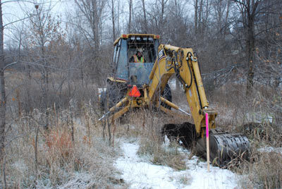
In the second round of testing, sites are identified for drilling or trenching, and ground samples are taken at regular intervals.
 |
|
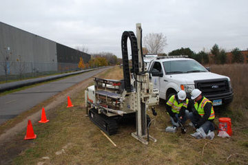
Left: Crews conducted soil borings and took water samples in late October along the LRT alignment east of Highway 100 in St. Louis Park. |
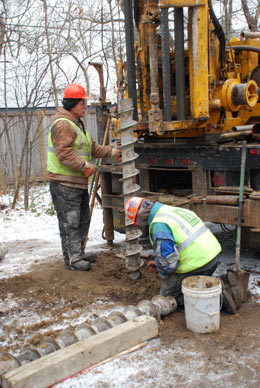
Right: In November, crews excavated test trenches. |
|
 |
 |
|
Left: Crews installed additional piezometers in the Kenilworth corridor to monitor ground water levels before LRT construction. |
This kind of testing is often done during a real estate transaction. Banks, for example, often require environmental work for transactions requiring large property loans.
The second round of testing is being conducted now so that the data is available for environmental and engineering work and land acquisition. Site assessment reports are expected to be complete by fall of 2015.
The testing is done to assess risks related to the potential contamination. Soil and ground water contaminants can include gasoline or diesel range organics, volatile organic compounds, metals, pesticides and asbestos, among others.
Once data is gathered and a report prepared, the Minnesota Pollution Control Agency (MPCA) will review it and a Response Action Plan, which will be publicly available.
As the Metropolitan Council conducts appraisals of properties that may be acquired for the LRT project, the appraisals will reflect the value of the property as though the contamination has been remediated. The appraisal will also consider the stigma associated with a property where contamination has been remediated.
If contamination is found on a property, landowners will be notified verbally and in writing during this round of testing. The Council will send the MPCA a copy of the notification. State law also requires landowners to notify the MPCA of any contamination found on their property.
The MPCA may take action related to contamination based on information in the report or the Response Action Plan.
A landowner may be required by the MPCA to clean up contamination that presents a risk to human health or the environment.
If contamination is entirely restricted to an area being considered for use by the Southwest LRT Project, the MPCA may accept the remedial work taken by the Council and require no additional work by the property owner. Such a decision is at the discretion of the MPCA.
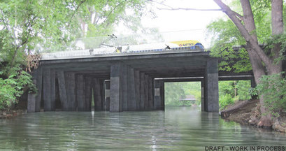
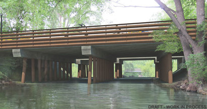
Kenilworth bridge concepts are nod to nature, railroad heritage
Three bridge concepts for the Kenilworth channel crossing on the Southwest LRT (METRO Green Line Extension) would reinterpret the existing wooden railroad bridge with new low-profile structures.
 |
|
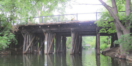
The existing wooden bridge (left) has six rows of wooden piers. Each side has different types of railing. View is looking west with the Burnham Road Bridge in the background. |
The project designers’ concepts feature arches, angled piers and a thin deck reminiscent of the existing railroad bridge and are fashioned to fit in with the natural surroundings, as initially recommended by several parties. “These are not full-blown designs. They are just in the idea stage for discussion as part of our consultation process for historic properties,” said Jim Alexander, director of design and engineering for the Southwest LRT Project.
The consultation, a federal requirement, will continue throughout the design process in 2015 for the freight railroad bridge and the combined LRT/trail bridge over the channel between Cedar Lake and Lake of the Isles. For more information, see metrocouncil.org/swlrt/news/kw-bridge-concepts.
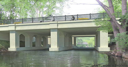
In the Arched Pier concept (below), concrete arched piers would support a concrete deck with steel railings, recalling the essence of the existing rail bridges of the Chain of Lakes area.
The Thin Deck concept (below) has angled concrete piers supporting a thin deck of concrete with light steel railings. The thin deck lessens the visual impact of the bridge over the channel. The concept would use charcoal-tinted concrete to reinterpret the existing wooden railroad bridge. Both the Arched Pier and Thin Deck concepts would be made of cast-in-place concrete.
The Steel Pier concept (below) uses natural steel to reinterpret the existing wooden railroad bridge. Angled piers made of natural steel support a concrete deck with natural steel railings that will weather to a warm brown patina.
 |
|
Left: Arched Pier bridge concept (artist's rendering). |
 |
|
Left: Thin Deck bridge concept (artist's rendering). |
 |
|
Left: Steel Pier bridge concept (artist's rendering). |
Hopkins gets Met Council grant to help attract pedestrians to downtown
As Hopkins prepares to redevelop a portion of its downtown in anticipation of the Southwest LRT’s arrival, the city is working to attract pedestrians to its downtown core.
To help, the Metropolitan Council recently awarded Hopkins a $1.3 million Livable Communities grant. The grants are competitive, aiming to leverage private investment and aid job growth in Twin Cities’ communities.
In Hopkins, the grant will be used to help fund utility and other work tied to the redevelopment of the Johnson Building and areas along Eighth Avenue, known as the ARTery. The two-block stretch will become a gateway between the planned Hopkins LRT Station and the heart of downtown Hopkins.
“We’re very excited to get the grant,” said Kersten Elverum, Hopkins’ director of economic development and planning. The redesign of Eighth Avenue “is our number one priority for what we really want to accomplish here.”
The ARTery will incorporate interactive public art that aims to attract development along the avenue. Many of the design concepts for the redesigned corridor came out of an art summit that the city held two years ago using a Corridors of Opportunity grant, Elverum said. The summit involved 47 residents and business representatives working together to integrate public art into the corridor.
In more recent meetings with property owners in the redevelopment area, feedback has been largely positive, Elverum added. Meetings with the broader community, where more of the plan details will be rolled out, are being planned for this winter.
Part of the vision for the blocks along Eighth Avenue was realized earlier this year when Gallery Flats, a new 90-unit apartment building with underground parking, began leasing to tenants, said Jason Gadd, a Hopkins City Council member.
The avenue’s redesign will also provide a link in the regional trail system, which is missing a connection between the Minnetonka Trail on the north side of downtown Hopkins and the Cedar Lake Regional Trail on the south along the Southwest LRT route.
Gadd is looking forward to additional public input to get more ideas on the plans for the avenue.
“It’s not too often you get to redesign a stretch of street like that,” he said.
About the Project:
The planned Southwest Light Rail Transit (LRT) Project (METRO Green Line Extension) will operate from downtown Minneapolis through the communities of St. Louis Park, Hopkins, Minnetonka, and Eden Prairie, passing in close proximity to the city of Edina. The line will connect major activity centers in the region including downtown Minneapolis, the Opus/Golden Triangle employment area in Minnetonka and Eden Prairie, Methodist Hospital in St. Louis Park, downtown Hopkins, the Eden Prairie Center Mall, and the Minneapolis Chain of Lakes. Ridership in 2030 is projected at nearly 34,000 weekday boardings. The project will interline with the METRO Green Line, which will provide a one-seat ride to destinations such as the University of Minnesota, state Capitol and downtown St. Paul. It will be part of an integrated system of transitways, including connections to the METRO Blue Line, the proposed METRO Blue Line Extension, the Northstar Commuter Rail line, a variety of major bus routes along the alignment, and proposed future transitway and rail lines. The Metropolitan Council will be the grantee of federal funds. The regional government agency is charged with building the line in partnership with the Minnesota Department of Transportation. The Southwest Corridor Management Committee, which includes commissioners from Hennepin County and the mayors of Minneapolis, St. Louis Park, Edina, Hopkins, Minnetonka, and Eden Prairie provides advice and oversight. Funding is provided by the Federal Transit Administration, Counties Transit Improvement Board (CTIB), state of Minnesota and Hennepin County Regional Railroad Authority (HCRRA). The Southwest LRT Project website is www.swlrt.org
|