Welcome to the second issue of 2014. The Water Talk* newsletter is published electronically 2-4 times a year, focusing on topics and resources related to floodplain management and other DNR land use programs: shoreland management, Wild & Scenic Rivers, and the Mississippi River Corridor Critical Area.
Our main target audience is local officials involved with floodplain management or mapping, as well as those at the watershed district, regional, state & federal level. Other target audiences include: surveyors, engineers, lenders, insurance agents, realtors, and others involved with properties or projects in the floodplain. If you did not receive this link directly, you can subscribe at: http://www.dnr.state.mn.us/waters/watermgmt_section/floodplain/index.html
Help us to keep our local official contact list current.If you are the city or county contact for zoning / permits, or the engineering contact, or the emergency manager, and you did not receive the link to this newsletter directly, please forward your contact information and role to ceil.strauss@state.mn.us
Please let us know what you think of the content and format of this newsletter, which will continue to evolve based on your feedback. Contact Ceil Strauss (see above) or suzanne.rhees@state.mn.us
After the Floods: Reminders for Local Zoning Officials
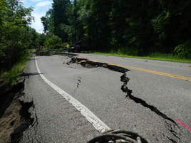
Roads and bridges were heavily damaged by floods and landslides in June 2014, as shown here in Blakely, Le Sueur County. Photo: Mary Presnail.
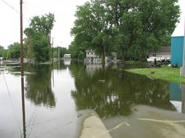
Buildings were affected by flooding in a limited number of areas; here in Waterville, for example. Photo, Randy Bradt.
The June 2014 floods hit areas all around the state, peaked, and are now receding.The first responders have done their immediate jobs.Some daring rescues were made.Those at risk were evacuated.Sandbags were passed out and placed with the help of many volunteers.Roads that were under water (sometimes fast moving water) were barricaded.Where the water levels are down, roads have been re-opened.In some areas, barricades have been left in place due to blown out bridges or landslides, etc.
Typically, once the immediate public safety concerns have been addressed, and the water levels are going down, everyone wants to get “back to normal” as fast as possible. Local officials will be following up in two main areas:
A. Public infrastructure repair and clean-up: emergency management and public works officials will be submitting damage reports through the county emergency manager.If the cost of the repair and clean-up reaches the required threshold level, a Presidential Declaration for Public Assistance (PA) will be requested to help pay the costs.(See http://www.fema.gov/declaration-process.)
B. Private repair & clean-up:
If a flood (or other disaster) is big enough, there can also be a Presidential declaration for Individual Assistance (IA).However, that trigger has not been reached the last several flood disasters in Minnesota (and is not expected as a result of the June 2014 floods).
Landowners with insurance should document damage and contact agents.Only flood insurance normally covers damage from flooding, although insurance riders may cover sump pump failure and sewer back-ups.
Local zoning officials are responsible for ensuring that all repairs within the regulated floodplain meets local ordinances.
What do local officials need to do to ensure repair and rebuilding after a flood (or other disaster) meet the local regulations? The following checklist highlights steps in the process:
1. Is the structure in the 1% annual chance floodplain (i.e., the “100-year” or mapped FEMA floodplain)?
Yes – go to Step 2
No – issue permits if required by building code or other parts of the local regulations
2.Was the structure or were any belongings affected by the flood?
Yes – go to Step 3
No – Document and issue permits if required by other local regulations.
3.Was there damage to the structure?
Yes – repairs to the structure and/or replacement of utilities (i.e., furnace, water heater, meters, etc.) are needed. – go to Step 4
No – no damage that requires repair of the structure or replacement of utilities.However, belongings may have been damaged, and the structure may have needed cleaning and disinfecting.Document conditions, provide information on local clean up resources, and issue permits if required by other local regulations.
4.Was the building “substantially damaged” (cost to bring to pre-flood condition is > 50% of the market value of the building, not including the land value, or it is a repetitive loss (if defined and regulated in the local ordinance)?
Yes – If the building is substantially damaged,it must be rebuilt in compliance with current local ordinances (i.e., it must be moved to a higher part of the lot, or elevated on fill or floodproofed).If the landowner has flood insurance, they are eligible for an Increased Cost of Compliance (ICC) flood insurance rider for up to $30,000 to pay for the cost to bring the building into compliance.DNR staff can assist local officials with looking at the options. State Homeland Security Emergency Management (HSEM) and DNR staff can also provide more information on mitigation grant options (i.e., to “buy out” willing sellers).
No – if not “substantially damaged,” the zoning office must issue a permit for any repairs that are needed.(The community can discount the cost of the permit, if they choose.)
DNR’s Flooding in Minnesota web page – links to: river gages, info for local zoning officials, clean-up resources, DNR general permits for repair of flood damages, and many other related links
One and Done: Culvert and Bridge Repair After Flooding
Less than a month before the June 2014 floods hit Minnesota, David Miller, the head of FEMA’s Federal Insurance and Mitigation Administration (FIMA) section spoke at the national Association of State Floodplain Managers (ASFPM) annual conference.Mr. Miller’s mantra was “one and done.”
He noted that the federal government comes in after disasters, and assists with paying for recovery over and over again.But public (and private) buildings and infrastructure should be reconstructed at locations and with standards such that they don’t need to be replaced after the next flood.There is an argument for the federal government to help once, but why are we paying to replace the same things over and over again?It should be “one and done!”
Federal law reforms since 2004 have targeted the cost for insurance claims that involve the “repetitive loss” structures.And the more recent reform acts of 2012 and 2014 step up the efforts to address those private structures.
But there are also many good reasons for the “one and done” approach with public infrastructure.The cost to taxpayers at the federal, state and local levels is a key reason.But there are also reasons at the local level to look at public road crossings with the “one and done” approach.When a bridge or culvert crossing is blown out, that can affect public safety during the flood.And, depending on how long it takes to repair that crossing, the increased travel time on alternate routes can affect regional commerce, emergency vehicle response time, etc.
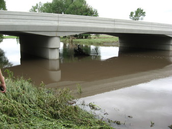
Example of Pipestone County bridge that had little damage. Photo: Brian Nyborg.
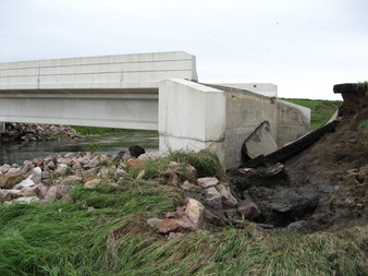
Example of bridge over Beaver Creek, Rock County, that was blown out.Flow was focused in one area. Photo: Brian Nyborg.
More flood resilient designs also have natural benefits
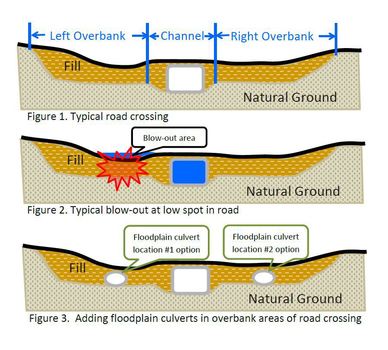
Roads constructed in the past often crossed wide natural floodplain areas with what is essentially a dike with a relatively small opening at a bridge or culvert for the river.As a result, a huge portion of the natural area for conveyance is blocked off during a flood.
Figure 1 shows a typical road crossing with a culvert in the river channel area.During a flood, the culvert fills and the floodwaters build up behind the road embankment.As shown in Figure 2, the floodwaters spill over once they reach the low spot.Often, the pressure and velocity of the floodwater at that low spot cause a blow-out adjacent to the culvert or bridge opening.
Figure 3 shows the option of placing “floodplain culverts” in the left and right overbank areas in order to reduce the velocity of floodwaters, and the resulting stresses, at the low point in the road.This also allows for more conveyance in the overbank areas of the natural floodplain, plus more “connectivity” for the floodplain habitat.Depending on the width of the overbank areas, adding more additional culverts can allow the floodwaters to be dispersed over a wider area, more closely mimicking the natural floodplain.This results in less erosion and potential for blowouts, and restores more of the natural benefits and functions of the floodplain.
DNR stream restoration and floodplain staff have been working together on studying the culvert designs that are more resilient to floodwaters, while providing more of the natural floodplain’s beneficial functions. There is a balance between the cost and the added benefits of additional culverts.As communities examine the flood damage and evaluate the needed repairs, DNR staff are assisting with design guidance to prevent future road crossing damages.If you have a recently flooded site where you’d like DNR to evaluate the benefits of adding floodplain culverts, contact your DNR Area Hydrologist or Salam Murtada at salam.murtada@state.mn.us
Note that FEMA public assistance funding (available after a Presidential declaration in that county) may be able to assist with the added cost of a design that will reduce flood damage potential.Learn more about funding under Section 406 (of the Stafford Act).
Flood Hazard Mitigation Grant Assistance Program Updates- May 2014
The 2014 legislature appropriated a total of $12 million in state bond and general fund monies for flood mitigation grants to local units of government.The DNR had requested $25 million this session, and received requests in excess of $30 million from local governments for 2014 project funding. Work is currently underway to most efficiently allocate the limited new funding to those communities at most risk of flooding.Department priority is to provide funding to community flood risk reduction projects nearing completion.
Of the $20 million that was allocated to the flood hazard mitigation grant program in 2013, less that $1 million remains uncommitted. These remaining funds will be spent to help complete flood mitigation projects currently under construction.
In response to flooding that affected parts of the state in the summer of 2012, resulting in a presidential disaster declaration (DR 4069), the state appropriated $12 million for flood mitigation and debris and sediment removal from public waters.The majority of these disaster funds have been spent on acquisition and removal of flood damaged or flood prone properties and debris and sediment removal in the affected area.There are limited uncommitted disaster funds remaining.If you represent a local unit of government in a county included in disaster DR 4069 (click here to check) and believe you have unmet flood mitigation or debris and sediment removal needs, please contact the DNR Flood Hazard Mitigation Grant Assistance Program Coordinator to discuss the possibility of state financial assistance.
Since 1987, the Flood Hazard Mitigation Grant Assistance Program has provided over $485 million in state funding to local units of government to help reduce flood risk across Minnesota.
Contact:Pat Lynch, Flood Hazard Mitigation Grant Assistance Coordinator @ 651.259.5691 or pat.lynch@state.mn.us
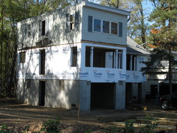
Floodproofing of a home in Lake St. Croix Beach through the Flood Hazard Mitigation Grant Assistance Program
Backlash to Biggert-Waters Reform Act of 2012: The Homeowners Flood Insurance Affordability Act (HFIAA) of 2014
(aka Grimm-Waters Reform Act of 2014, or GW-14)
The Biggert Waters Reform Act of 2012 (BW-12) was discussed in the March 2014 edition of Water Talk.While BW-12, which was signed July 6, 2012, had many provisions affecting floodplain mapping and grants at the national level, the changes on the flood insurance side got the most attention around the nation from impacted landowners and their elected officials.
Impacts on Flood Insurance Rates
The BW-12 requirement for many owners of older buildings to immediately pay full risk rates upon purchase of properties and for new policies led to many cases where rates were increasing to 5 – 10 times what they had been.The media and elected officials reported even more extreme premium increases, especially in coastal areas.The real estate market ground to a halt in communities with a high percent of properties in the mapped floodplain.In reaction to those concerns, the Homeowners Flood Insurance Affordability Act (HFIAA) was signed into law March 21, 2014.(The law is also known as the Grimm-Waters Reform Act of 2014, or “GW-14”).
Other Key Flood Insurance Provisions in the New Law
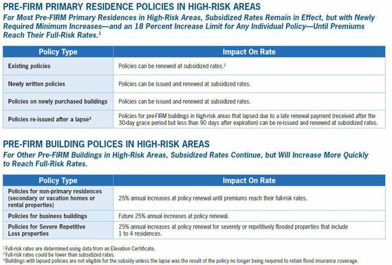
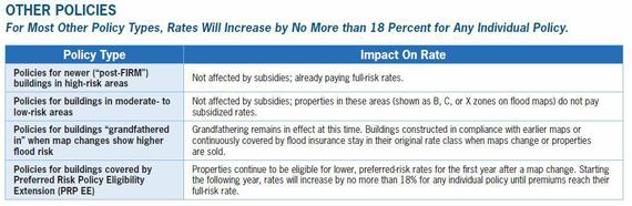
New Surcharge – A new surcharge (to be implemented in 2015) will be added to all new and renewed policies to offset the subsidized policies and meet the financial stability goals of the recent reform acts.A policy for a primary residence will include a $25 surcharge.All other policies will include a $250 surcharge.This new surcharge will be included on all policies, including full-risk-rated policies and Preferred Risk Policies (PRPs).
Refunds – BW-12 required an immediate move to property-specific, full risk rates when pre-FIRM buildings were sold or new policies issued.Some policyholders saw significant premium increases.The new law allows a return to subsidized rates for most properties – and refunds of the difference paid between the subsidized rate and current full-risk rate.FEMA is working with participating insurance companies to start the refund process by the end of 2014.
Highlights of Other Provisions in the New Law
No review fee for Letters of Map Revisions (LOMRs) for habitat improvement projects
Communities can be reimbursed for successful appeals of new FEMA maps
Requires the Technical Mapping Advisory Council (TMAC) to review the new national flood mapping program authorized under the 2012 and 2014 reform laws
Requires an affordability framework
Requires FEMA to designate a Flood Insurance Advocate
Requires that flood mitigation activities be considered for premium rates (i.e., discounts for categories of activities that reduce flood damage potential)
Restores substantial improvement trigger to 50% (was changed to 30% in BW-12)
Study of voluntary community-based flood insurance
Requires FEMA to clearly communicate full flood risk determinations to individual property owners regardless of whether their premium rates will be full risk rates
Floodplain Management Training is a free one-day course designed for local officials, surveyors and engineers, realtors, insurance agents, and other interested citizens. The 2014 sessions include both general and specialized topics:
Floodplain zoning basics
Floodplain map basics
Letters of map change (LOMA, LOMR-F and LOMR)
Flood insurance basics - including the latest insurance reform
Ordinance administration
Estimating base flood elevations in A zones
Higher regulatory standards
The next training session will be held on Wednesday, September 10, at the Mille Lacs County Building, Milaca. The session runs from 9:00 am to 4:00 pm, with registration at 8:30 am. To register, e-mail ceil.strauss@state.mn.us or call Ceil at 651-259-5713.
Additional locations will be added later in 2014, so watch for updates.
A Practical Guide to Variances in Shorelands & Floodplains will be offered through GTS Educational Events on Wednesday, October 29, from 1:00 - 5:00 pm, at Arrowwod Resort & Conference Center. Learn from the experts how to make decisions in light of Minnesota's changed variance laws. Includes why the regulations are important, special considerations when dealing with these sensitive areas, and exercises based on actual situations.
See www.mngts.org/LandUse for further information, or contact Carol Schoeneck at 651-222-7409, ext. 205.
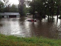
Illinois Communities Sued for Failure to Prepare for Floods.
On April 17, Illinois Farmers Insurance Company filed nine class action lawsuits against nearly 200 communities in the Chicago area, alleging that the communities failed to take necessary steps to limit damage from an April 2013 flood event.By June, however, the company had dropped all the lawsuits.
Heavy rains, a slow moving storm system, and pre-saturated soil conditions resulted in record flooding in large parts of Illinois in April 2013.Governor Pat Quinn declared 48 counties disaster areas, and the National Weather Service estimated $375 million in damages from flash and river flooding.
Farmers sued for reimbursement of claims it had paid out to more than 600 affected property owners, alleging that the local governments did not do enough to prevent or reduce flood damage.The company argued that the damage could have been mitigated by better management and operation of common flood mitigation structures; that the communities were aware of the risk, based on past flooding and flood studies; and that, had the communities properly prepared for flood events, the damage would not have been as extensive.The company also argued that municipalities should have planned for more severe flooding as a result of climate change.
As of June 3, however, Farmers Insurance Group dropped the lawsuits, stating that, essentially, their point had been made and that they hoped the suits would encourage cities and counties to do more to reduce flood risks.State laws and legal precedent generally protect governments against such lawsuits, but some environmental law experts predict an increase in legal actions over who should be liable for the possible costs of climate change.
Major flooding in the Chicago area, April 2013.
Floodplain Management Training is a free one-day course designed for local officials, surveyors and engineers, realtors, insurance agents, and other interested citizens.The 2014 sessions include both general and specialized topics:
Floodplain zoning basics
Floodplain map basics
Letters of map change (LOMA, LOMR-F and LOMR)
Flood insurance basics - including the latest insurance reform
Ordinance administration
Estimating base flood elevations in A zones
Higher regulatory standards
The next training session will be held on Wednesday, September 10, at the Mille Lacs County Building, Milaca. The session runs from 9:00 am to 4:00 pm, with registration at 8:30 am. To register, e-mail ceil.strauss@state.mn.us or call Ceil at 651-259-5713.
Additional locations will be added later in 2014, so watch for updates.
A Practical Guide to Variances in Shorelands & Floodplains will be offered through GTS Educational Events on Wednesday, October 29, from 1:00 - 5:00 pm, at Arrowwod Resort & Conference Center. Learn from the experts how to make decisions in light of Minnesota's changed variance laws. Includes why the regulations are important, special considerations when dealing with these sensitive areas, and exercises based on actual situations.
See www.mngts.org/LandUse for further information, or contact Carol Schoeneck at 651-222-7409, ext. 205.
FEMA Map Updates
New Maps Going Effective:
McLeod County – Effective on July 7, 2014
Freeborn County – Effective on November 19, 2014
Letters of Final Determination (Letters sent 6 months before effective dates):
Hennepin County – September 2014
Mahnomen County – September 2014
Norman County – September 2014
Olmsted County – September 2014
90-Day Appeal Periods:
Crow Wing County – August 2014
Kandiyohi County – August 2014
Scott County – August 2014
Preliminary Maps To Be Released:
Polk County – July 2014
Houston County – September 2014
Winona County – December 2014
Mississippi River Corridor Critical Area: Public Meetings on Rulemaking
The Minnesota Department of Natural Resources (DNR) is holding three public information meetings on the rulemaking currently underway for the Mississippi River Corridor Critical Area (MRCCA). All meetings will run from 6:30 to 9:00 PM, at these locations:
Tuesday, July 22 - Nova Classical Academy, 1455 Victoria Way W., St. Paul, MN 55102
Thursday, July 24 - Schaar's Bluff Gathering Center (Spring Lake Park Reserve), 8395 127th Street E, Hastings, MN 55033
The DNR will present the same information at each meeting.The meetings will be in an open house format, with a presentation and discussion scheduled from 7:00 to 8:00 pm. Stop in at any time to learn more about the MRCCA rulemaking, and provide feedback on the draft rules, focusing on key topics such as vegetation, land alteration, setbacks, nonconformities, and shoreline facilities.DNR staff will be available to explain how the draft rules might affect individual properties. Comments received at these meetings are not part of the formal rulemaking record but will be considered as draft rules are revised.
The MRCCA is a land corridor along the Mississippi River within the seven-county metro area. There are 30 local governments within the 72 mile long, 54,000 acre corridor. Land development in the corridor is guided by existing state regulations, which are implemented through local government plans and zoning ordinances.The proposed rules, if adopted, would replace the existing regulations. A Request for Comments on the proposed rules was published in the State Register on June 2, 2014. The DNR will accept comments until 4:30 p.m. on Friday, August 15, 2014.
Save the Date for the 2014 MNAFPM Annual Conference
November 19 – 21 in Duluth
The 2014 MnAFPM conference will be held in Duluth, MN at the Holiday Inn Hotel and Conference Center. The theme of this year's conference is, "It Doesn't Flood Here! Locations Not Historically Prone to Flooding."
MnAFPM encourages federal, state, and local government officials, planners, engineers, consultants, researchers, educators, watershed organizations, realtors, appraisers and insurance agents to attend the conference. On Wednesday, November 19, several training opportunities and a field tour will be offered. The conference will take place on Thursday, November 20 with plenary and concurrent sessions, networking events and a comprehensive products/services exposition. The CFM exam will be given on Friday, November 21.
Abstract topics include:
Restoration/Mitigation Plans
Regulatory Updates
Hydrologic & Hydraulic Modeling
Impacts of Recent Floods
Urban Flooding & Drainage Systems
Emergency Response
Design/Construction of Flood
Protection Measures
Levee/Dam Issues
New Technology
Public Awareness/Education
Anyone wishing to make a presentation must submit an abstract describing the material to be presented. Please include a brief bio and small head-shot photo of yourself. E-mail your abstract submission to Mary Presnail. Abstracts are due by June 30, 2014. Authors selected as presenters must register for the conference. See http://www.mnafpm.org/conference for further information.