|
A New Option for Stream and Wetland Mitigation is Now Available in Indiana
By Carl Wodrich, Brad Baldwin, & David Carr, Division of Land Acquisition.
The Indiana Department of Natural Resources (DNR) is excited to be the sponsor of the Indiana Stream and Wetland Mitigation Program (IN SWMP), an in-lieu fee (ILF) mitigation program, which was approved by the U.S. Army Corps of Engineers (Corps) on May 3, 2018.
IN SWMP is an ILF mitigation program sponsored by DNR and regulated under the 2008 federal mitigation rule. The program allows the DNR to sell credits to satisfy stream and wetland mitigation requirements for unavoidable impacts to waters of the United States and isolated wetlands in the State of Indiana in accordance with permits issued by the Corps under Section 10 of the Rivers and Harbors Act of 1899 and Section 404 of the Clean Water Act (CWA) for the discharge of dredged and/or fill material into “waters of the U.S.,” and permits issued by Indiana Department of Environmental Management (IDEM) per a Section 401 Water Quality Certification of the CWA and/or Indiana’s Isolated Wetlands law.
What is an ILF Program?
An ILF program provides one option for mitigating for these unavoidable impacts to waters of the U.S. and/or waters of the state. This involves purchase of credits to an ILF program sponsor with appropriate approvals from the Corps, in-lieu of performing the mitigation themselves (permittee-responsible mitigation). An ILF program involves the restoration, establishment, enhancement and/or preservation of aquatic resources after impacts have occurred on the landscape. The legal obligation to provide the compensatory mitigation required by the authorized permits is then transferred to the sponsor of the ILF program upon receipt of funds for credits sold to permittees in a specific ILF service area.
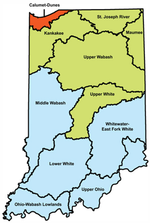
The Indiana DNR has divided the state into 11 services areas for the program, primarily based upon watersheds. The service areas are made up of one or more eight-digit watersheds that have similar aquatic habitat systems and watershed characteristics.
How Do I Buy Credits to Fulfill Mitigation Requirements?
Credits can only be purchased once you have final, approved and signed Corps and/or IDEM permits in hand. The credit purchase process can be found on our web site at on.IN.gov/inswmp
|
Partnerships Will Be Key to Program and Project Success
DNR’s IN SWMP seeks landowners and conservation organizations interested in the restoration and conservation of Indiana’s aquatic resources and associated habitats for project sites and partnerships. IN SWMP will have to plan, design, construct, monitor, maintain, and provide long-term management for ILF mitigation projects that will restore Indiana’s streams, floodplains, and wetlands. These areas will have to be permanently protected through real estate instruments such as conservation easements.
DNR program staff are looking for willing property owners who have land containing streams and/or wetlands in need of, or with potential for, restoration. The goal is to restore aquatic resources by improving water quality and providing greater and/or enhanced habitat for fish and wildlife to achieve a no-net loss of aquatic resources in Indiana. Statewide conservation initiatives, such as the State Wildlife Action Plan, are considered when prioritizing projects for selection.
DNR IN SWMP recognizes that locally based watershed needs are best identified by local stakeholders that live and/or operate within that watershed. They know the threats to, historic loss, and current condition of their aquatic resources. The conservation goals and objectives prioritized by the local groups to help improve the ecological functions and services these resources provide will assist in ensuring that mitigation projects provide those necessary services to the local community.
Together, we have the opportunity to plan and carry out aquatic resource restorations using a landscape-based watershed approach that will result in a significant ecological uplift for mitigation projects in Indiana that will have long-term protection and management in perpetuity.
All potential restoration projects will be screened by program staff based upon factors such as feasibility, cost, credit generation, and compatibility with addressing the parameters outlined in the Compensation Planning Framework. When a project passes the initial screening by DNR staff, DNR will draft and submit a conceptual plan to the Corps and Interagency Review Team (IRT) agencies. If the project is approved to move forward by the Corps, DNR will put together a design and full mitigation plan for the site for final approval of the project. DNR intends to work with the long-term management conservation partner through the design process. Once approved, DNR can bid the project out for construction and then enter the performance monitoring phase until the project is released from regulatory authority and when it meets performance metrics. Then the project can move into long-term monitoring and maintenance once a management plan and budget are approved.
Questions about the typical criteria for restoration projects can be emailed to INSWMP-Inquiry@dnr.IN.gov.
Additionally, the Indiana Natural Resources Commission (NRC) adopted new rules allowing for ILF credits as an option for mitigating impacts to fish and wildlife for permits that DNR issues for construction in a floodway, public freshwater lake or navigable waterway through the Division of Water. While this rule was formally adopted by the NRC, it is not yet in effect. The DNR Division of Fish & Wildlife is working on a non-rule policy document that will provide additional details.
 Flood Prone Area & Special Flood Hazard Area
By Doug Wagner, Division of Water
Floodplain administrators who review building plans and permit applications, as required for communities that participate in the National Flood Insurance Program (NFIP), must understand what is meant by “Flood Prone Area” and “Special Flood Hazard Area.” The Indiana model floodplain ordinance defines the terms as follows:
Flood Prone Area means any land area acknowledged by a community as being susceptible to inundation by water from any source.
Special Flood Hazard Area (SFHA) means those lands within the jurisdiction of a community subject to inundation by the regulatory flood. The SFHAs of a community are generally identified on the community’s Flood Insurance Rate Map (FIRM), prepared by the Federal Emergency Management Agency (FEMA) with the most recent date. In the absence of a published FEMA map, or absence of identification on a FEMA map, the SFHA shall be as provided by the Indiana Department of Natural Resources, including but not limited to areas mapped on the best available floodplains data layer as provided by the Indiana Department of Natural Resources (DNR).
It is important that floodplain administrators understand that not all SFHAs are identified on the community’s Flood Insurance Rate Map (FIRM) panels. Many existing flood hazard areas have not yet been studied and are not currently shown on the FIRM maps due to the cost associated with mapping processes. Some existing flood hazard areas simply were given low priority when most of the state’s initial FIRMs were produced due to of the lack of land development, or the land use at that time. Many of these areas were agricultural at the time the FIRMs were first developed. The highest consideration was given to existing areas of high development and/or the larger streams/waterbodies. Some communities have recognized the need for additional flood studies within their jurisdiction and invested in having portions of their flood hazards studied, ultimately revising their FIRMs through the Letter of Map Revision (LOMR) process.
Lack of identification of the flood hazard can result in communities allowing non-compliant and/or unwise development of SFHAs without realizing it. This is more prone to happen when a community is growing—trying to attract new businesses, or wanting to develop subdivisions to attract residents on properties that may lie near a stream or other waterbody. When a FIRM later becomes effective and/or a detailed study is completed by FEMA that identifies flood hazards not previously reflected on the FIRM, it may leave a property owner saddled with costly flood insurance premiums. A community may also face violations if it is noticed that it is allowing construction in a floodway of a stream that does not appear on the FIRM. Something such as this may force the removal of a residence or other structure after it is completed.
While the effective FIRM is the official map that lenders and agents must use for making determinations in regard to federal mandatory flood insurance requirements, it is not the only resource for regulatory flood data used for permitting and construction purposes. This is an important distinction. This requirement is the reason local ordinances include language to provide the basis for establishing the regulatory flood data. This includes language specifically to address the regulatory flood elevation, floodway, and fringe limits for watercourses in the absence of a published FEMA map, or absence of identification on a FEMA map. A floodplain (floodway and flood fringe) exists for each waterway even if an area is not delineated on a map.
In accordance with the Flood Control Act IC 14-28-1, the Indiana Department of Natural Resources (DNR) has regulatory authority over any stream having an upstream drainage area greater than one square mile. DNR also provides the Base Flood Elevation (BFE) and Floodway or Fringe determination for these streams. Recently, DNR completed the mapping of more than 19,000 stream miles that were Zone A (approximate study) or previously unmapped. This was done largely through the use of LiDAR data providing better analysis without the costly field surveys being required in a detailed study.
With this study, floodways were developed in all the “A” zone areas and in areas previously unmapped. DNR now has 19,396 miles of Zone A elevation points and 4,658 miles of detailed elevation points for a total of 2,550,000 elevation points, more than doubling the number of points in just the last two years. The number of Zone A stream miles has also increased from 7,430 to 19,396 miles, increasing the approximate miles by slightly over two and one half. In some instances these further studies have reduced the BFE for some sites. This reduction may reduce the cost of flood insurance for current policy holders or even enable them to be removed them from the SFHA.
With the Biggert-Waters Act (BW-12) and Homeowner Flood Insurance Affordability Act (HFIAA) increasing premiums, for existing pre-FIRM buildings, subsidized policies will ultimately be phased out, and all policies will eventually be based on actual risk (the relationship between lowest floor of a building and the BFE).
It will be important for local officials to share this information with their community members so they may reap the benefits of the lower BFEs when applicable, or investigate retrofitting of pre-FIRM structures, when appropriate, to reduce the flood risk and the corresponding flood insurance cost. They should also share the best available floodplain data developed for the community to assist in controlling development in these areas. This will make property owners aware of their true flood risk.
SUMMER WORKSHOPS
By Doug Wagner, Division of Water
The DNR Division of Water will conduct summer workshops titled “Popular NFIP Topics” in June. Details for each workshop location are listed below (all times are local):
June 11 9:30 a.m. – 4 p.m. Schererville (Lake County)
Schererville Town Hall
10 E. Joliet Street
Schererville, IN 46375
June 19 9:30 a.m. – 4 p.m. Shipshewana (LaGrange County)
Wolfe Community Building
345 N. Morton Street
Shipshewana, IN 46565
June 25 9:30 a.m. – 4 p.m. Petersburg (Pike County)
Petersburg Fire Department
624 E. Illinois Street
Petersburg, IN 47567
Community leaders, floodplain administrators, and other individuals involved in floodplain management are welcome to attend.
This workshop is eligible for Continuing Education Credits for Certified Floodplain Managers (CFMs). Register by contacting Doug Wagner at dwagner1@dnr.IN.gov or 317-232-4178 (direct) or 877-928-3755 (toll free). Registration is required to ensure materials are available for all attendees.
CONGRATULATIONS TO NEW CFMs
By Doug Wagner, Division of Water
After completing the exam in March, four new Certified Floodplain Managers (CFMs) from Indiana were added to the growing list of floodplain management professionals across the nation. The most recent additions are Kenneth (Jordan) Smithers & Mary Taitano both of Indianapolis, Donald Newell of Rome, and Carlisle Buddin of Bloomington.
This national program for professional certification of floodplain managers was established by the Association of State Floodplain Managers. The program recognizes continuing education and professional development that enhances the knowledge and performance of local, state, federal and private-sector floodplain managers.
Congratulations!
|
2019 INAFSM CONFERENCE
By Doug Wagner, Division of Water
The Indiana Association for Floodplain and Stormwater Management will have its 22nd Annual Conference, Sept. 4-6, at the Grand Wayne Convention Center in Fort Wayne. Mark your calendars and register for the conference before July 5 to receive the early bird discount. For more information about the INAFSM conference and the organization, visit inafsm.net.
CFM EXAM OFFERING
As part of the INAFSM conference, the DNR Division of Water will again proctor the CFM exam on Thursday, Sept. 5, at the Grand Wayne Convention Center in Fort Wayne from 2:25 – 5:25 p.m. An instructional session on NFIP basics will be held on Wednesday, Sept. 4 at the same location from 2:20 - 5:15 p.m.
To take the CFM exam, you must complete and submit the CFM Program Application Package to the Association of State Floodplain Managers (ASFPM). The forms are available on the ASFPM website, floods.org, under the Certification Program tab. The fee is $100 for ASFPM members and $450 for non-members.
You may submit an application for ASFPM membership at the same time you apply to take the exam. To be accepted to take the exam at this scheduled time, you must submit your completed application and pay the appropriate fee to ASFPM by Aug. 21. No walk-ins will be allowed unless authorized by the ASFPM executive office. For specific information on the location and times, contact Doug Wagner at dwagner1@dnr.IN.gov
|

Indiana Training Opportunities – 2019
(Information provided by FEMA)
Indiana Department of Homeland Security
Please visit the Indiana Department of Homeland Security’s training calendar for upcoming courses and trainings at https://oas.dhs.in.gov/hs/training/public/calendar.do.
Association of State Floodplain Managers (ASFPM)
ASFPM has an online training program, and training is added regularly. See http://www.floods.org/n-calendar/webinars.asp for more information.
FEMA’s Emergency Management Institute (EMI)
E0273: Managing Floodplain Development through the NFIP. Aug. 26-29 and Dec. 2-5, Emmitsburg, Md. This course provides an organized training opportunity for local officials responsible for administering their local floodplain management ordinance. The course will focus on the National Flood Insurance Program and concepts of floodplain management, maps and studies, ordinance administration, and the relationship between floodplain management and flood insurance.
E0278: NFIP/Community Rating System. Oct. 28-31, 2019 and Feb 2-6, 2020, Emmitsburg, Md. This course covers the Community Rating System (CRS), a nationwide initiative of FEMA’s National Flood Insurance Program (NFIP). It describes activities eligible for credit under the 2013 CRS Coordinator’s Manual, how a community applies, and how a community modifies an application to improve its classification.
E0282: Advanced Floodplain Management Concepts II. July 15-18, 2019 and March 16-19, 2020, Emmitsburg, Md. This advanced floodplain management course is a dynamic and interactive instruction that covers the following four topics in detail: Placement of Manufactured Homes and Recreational Vehicles in the Floodplain, National Flood Insurance Program Flood Insurance Principles for the Floodplain Manager, Higher Standards in Floodplain Management, and Hydrology and Hydraulics for the Floodplain Manager. Each topic is designed to be discussed and reviewed in greater detail than the basic course. Developed and real-life scenarios will be examined and activities will be conducted in each section to make sure participants not only understand the rules and regulations but also why they are in place and how to apply them in the particular topic areas. This course is activity-rich, and participants can expect to be engaged throughout.
E0284: Advanced Floodplain Management Concepts III. July 6-9, Emmitsburg, Md. This advanced floodplain management course is a dynamic and interactive instruction that covers the following five topics in detail: Floodway Standards, Disconnects between National Flood Insurance Program Regulations and Insurance, Common Noncompliance Issues, Digital Flood Insurance Rate Maps (DFIRMs), and Substantial Improvement/ Substantial Damage. Each topic is designed to be discussed and reviewed in greater detail than the basic course. Developed and real-life scenarios will be examined and activities will be conducted in each section to make sure participants not only understand the rules and regulations but also why they are in place and how to apply them in the particular topic areas. This course is activity-rich, and participants can expect to be engaged throughout.
EMI also offers many more courses in Emmitsburg, around the country and through webinar training opportunities online. For additional information on EMI classes and webinars, please visit EMI’s training calendar website and its course catalog.
Other Trainings and Conferences
Association of State Floodplain Managers. June 7-11, 2020, Fort Worth, TX. The ASFPM annual conferences are recognized as the most important floodplain conference in the United States year after year. With more than 100 speakers and more than 1,200 participants, they are the national conferences all community, state and federal floodplain managers plan to attend. Please visit the ASFPM’s conference website for more information at http://www.asfpmconference.org/.
|
THANK YOU
Thanks to those contributing to this issue: Carl Wodrich, Brad Baldwin, David Carr, George Bowman, Ryan Mueller, Marty Benson, Don Kaczorowski, Anita Nance, Darren Pearson, and Ed Reynolds.
Editor – Doug Wagner
The work that provides the basis for this newsletter was supported by funding under a cooperative agreement with the Federal Emergency Management Agency. The author and publisher are solely responsible for the accuracy of the statements and interpretations contained in the publication. Such interpretations do not necessarily reflect the views of the federal government.
Waterlines is produced biannually as a public service by the DNR Division of Water.
Waterlines is available on the web at dnr.IN.gov/water.
Having trouble viewing this email? View it as a Web page.
|