|
Introducing the new “Division of Water’s Online Research Center” (DoWORC)
By Division of Water Staff
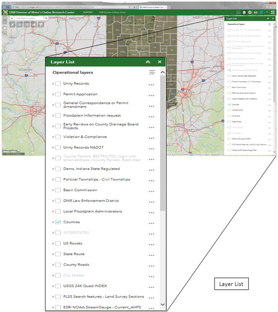
The Indiana Department of Natural Resources, Division of Water, is pleased to announce a new web-based mapping service. The service provides the general public the use of a geographical map to locate and view data from records associated with programs administered by the Division of Water. Various other dataset layers including flood hazard maps, local floodplain administrator’s contact information, Hoggatt Drainage Area Maps, and Stream Gage data can also be viewed.
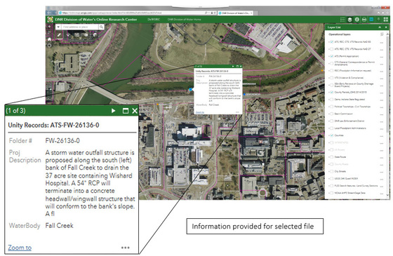
With the use of ESRIs ArcGIS-On-Line software, DoWORC has been developed by DNR to allow the general public to view layers of datasets to easily view, locate, and search for information from the Division of Water records including permit applications, floodplain information requests (FARA), Early Coordination records, Dam records, Violation and Compliance records, and other regulatory correspondence. DoWORC interfaces with the Division of Water’s database by the use of Universal Transverse Mercator (UTM) coordinates to display a data point on the map that references the location of the record and with a click of the mouse on a data point, DoWORC will retrieve and display a collection of helpful information from that record such as file number, waterbody, project or request description, base flood elevation, discharge value, action, mailed date, etc.
Check out this new map service on the Division of Water’s homepage.
Additional detailed instructions on using DoWORC are available on the DNR Division of Water’s homepage.
 Director’s Message
By Ryan Mueller, Division of Water
Greetings! I’m writing this introductory message as the new director of the Division of Water. It is an honor to succeed Michael Neyer as director after his retirement. His long and distinguished career as a steward and leader in water resources management served the state of Indiana well.
My family and I are relatively new to Indiana. We moved from Columbia, Missouri to Bloomington after my wife Heather accepted a faculty position at Indiana University. It’s been a great move for us. We’ve enjoyed exploring the state and we’re happy to be new Hoosiers!
Before our move, I served as the director of water resources for the Missouri DNR from 2006 – 2014. During that time, my co-workers and I led the expansion of Missouri’s water resources monitoring networks, developed emergency action plans that raised awareness and enhanced response capabilities for regulated dams, and assisted Missouri communities address water resource challenges such as drought vulnerability, increasing water demand and planning for regional water supplies. Much of this work was shaped during periods of record flooding and prolonged drought, conditions that reinforced the importance of cooperative water resources planning and integrated management.
After my time with Missouri DNR, I spent three years as the executive director of the Interstate Council on Water Policy (ICWP). ICWP is a national non-profit organization that advocates for the importance of fundamental hydrologic monitoring and data collection networks. These networks provide information for the entire water cycle and represent the “backbone” for water resource decision-making, planning and response coordination across all levels of government, the private sector and the public.
I’ve been impressed with the interest in and cooperative spirit for addressing water resource issues in Indiana. A great example of coordination is the Indiana Silver Jackets team. Silver Jacket members include federal, state, academic and other non-federal partners that seek to develop solutions to natural hazard issues. The Indiana Silver Jackets team serves as a forum for information and data sharing, strategic planning, coordinating communications and developing tools that enhance the warning, mitigation and response capabilities during natural hazards such as flood events. To learn more about the Indiana Silver Jackets you can visit: http://silverjackets.nfrmp.us/State-Teams/Indiana.
Thanks for your interest. I look forward to meeting and working with you as we address Indiana’s water resource challenges and opportunities.
|
Trees are part of the answer
By Carrie Tauscher, Division of Forestry
Our community trees provide an immense amount of value to communities across the state to the tune of $304 million annually. (IAATCC2011) As the impact from invasive pests like the emerald ash borer (EAB) compiled with drought stress, intensified storm events, land-cover change in the form of development, and overall aging tree populations takes its toll, cities and towns across Indiana are beginning to feel the effect that a loss of tree canopy can make.
We know that trees make communities beautiful places to live, work and play, but more and more research is showing that trees also make communities healthier, smarter, and safer places. Infant birth weights are higher in neighborhoods with tree-lined streets. Neighborhoods with higher tree-canopy cover have fewer emergency room visits for respiratory-, cardiac-, and asthma-related illnesses during hot summer months. Domestic violence rates are lower in neighborhoods with trees and public parks. Students score higher on standardized tests when classrooms have views of the green outdoors and trees. Families are more likely to walk or ride their bikes to a local park, reducing car traffic and emissions, when streets are lined with trees. Citizens suffering from mental-health and substance-abuse issues recover during treatment faster in facilities with open park settings and forest walks. While not the end all be all to the world’s problems, trees that are managed for their beauty and ecosystem services as community infrastructure rather than decoration can make a lasting impact on Indiana’s communities.
Plant more trees more often… and care for them
Often communities use tree planting as icing on the cake as part of a beautification or “greening” initiative. Therein lies the problem. Trees are a critical part of green stormwater infrastructure for every community. To that point, trees need to be maintained, managed and expanded as communities grow and change, just as other community infrastructure is. As impervious surfaces increase in communities, the opportunity for cost-effective green infrastructure becomes challenging. When tree planting is not considered as a valuable, cost-effective tool that operates near, under, and over impervious surfaces, communities lose out.
 By preserving, planning for, and planting trees as a part of regular development and infrastructure planning, our communities invest in a form of infrastructure that increases in value over time compared to traditional infrastructure, which tends to break down over time.
As trees increase in size so does their ability to provide ecosystem services. Proper watering into establishment, and care for established trees is critical in getting trees to the 10-20 year mark where the benefits provided by a tree far outweigh the monetary investment. Conversely, trees planted with no follow-up care frequently fail. Trees planted with no establishment care plan or budget commonly show signs of stunted growth, disease, and, in the worst case, high mortality rates. This means they provide fewer benefits than projected or none at all.
When trees are cared for, on average, in the State of Indiana, communities gain $2.77 in benefits for every $1 invested in the planting and care of trees (SUSI 2009). In communities with larger populations and greater density like Fort Wayne, the cost-benefit ratio increases to 5.55:1.
|
Modeling benefits and Tree Population Analysis Tools: i-Tree
 The Tree Benefit modeling tool i-Tree is a free, open-source, and internationally recognized modeling tool developed by the U.S. Forest Service and the nonprofit organization Casey Trees. While this is a regularly used tool among professionals in urban forestry it has only been recently recognized in the fields of stormwater management, planning, civil engineering, and landscape architecture.
In the last 10-15 years, i-Tree has evolved based on user feedback and practitioner needs. It has become a site of specialized tools that include Eco, Streets, Canopy, Hydro, Landscape, Design and the mobile app MyTree. Each unique tool caters to analysis and modeling needs of differing audiences, landscape scales, and data inputs.
Any one of you could easily run a basic benefits calculation for a single tree using a simplified face of the same analysis tool. The National Tree Benefit Calculator can calculate the annual benefit of a single tree with basic data entry. For example, by entering a street address or zip code, diameter at breast height (DBH) measurement of the tree and adjacent land use, you can run an analysis based on local benefit values. Example: 18” DBH silver maple in Greenwood, IN, in a single-family residential neighborhood. While not the most savory of species, our 18-inch silver maple will provide a value of $75 in ecosystem services this year. These services can be broken down into multiple-service categories, and the impact estimated based on regional tree growth, weather patterns and costs of pollutant mitigation, and water treatment.
Annual benefit of an 18” Silver Maple
• Stormwater mitigated - 4,250 gal
• Carbon sequestration - 403lbs
• Increased property value - $37
• Energy savings - 81KWH
While the dollar value of this mitigation for one tree may seem small at $75 this year, remember to keep it in context. This is but one tree that is part of a larger urban forest canopy. For example the city of Goshen has 2,311 maple trees in their public right of way (ROW) with an average DBH of 20 inches. At $75 in benefits annually per tree, Goshen receives $173,325 in benefits just from publicly managed silver maple trees. All total, Goshen’s public trees intercept over 19 million gallons of stormwater per year (Goshen 2012).
|

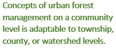
In communities that have complete street and park tree inventories, we can more accurately quantify the benefits of municipally managed trees, which equate to about 25% of a community’s total urban forest. Why only 25%? The remaining 75-80% of the urban forest is held on private property and the trees in your backyard are much more difficult to inventory on a stem-by-stem basis. That means that how private landowners manage their trees in our communities really matters!
Communities can lead by example following locally and internationally recognized BMPs for management and green stormwater infrastructure implementation.
 Chesterton, Indiana Example
A complete inventory though i-tree analysis gives a larger view of the benefits provided by urban trees. In an inventory analysis from Chesterton, IN, in 2012, the overall value of ecosystem services came in at just over $548,000. At that time it was estimated that, based on the expenditures made for tree care, the cost-benefit for trees in Chesterton was 11.25:1. For every dollar invested in tree planting, watering, pruning, removals, infrastructure repairs, and litter cleanup, the city gained $11.25 in benefits.
Focusing specifically on stormwater; eight million gallons stormwater are/were intercepted by street trees annually with a value of $216,793. That volume benefited the community in avoided stormwater treatment costs and the reduction of flash flood occurrences due to reduced peak flows during storm events.
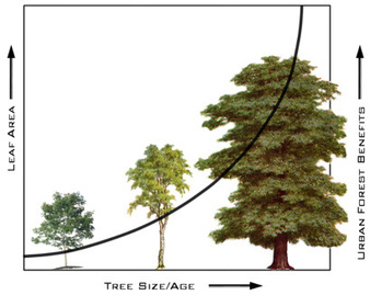
Big trees equate to larger benefits due to increased leaf and stem surface area as well as increased uptake and percolation. But it’s not all rainbows and sunshine for Chesterton. By 2012 the City of Chesterton had lost a major portion of its population of ash trees due to EAB. The benefit from ash in their community was reduced to just over 4,000 gallons of stormwater being mitigated by the remaining ash trees. We can assume that benefit has been lost now, five years later.
|
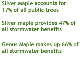
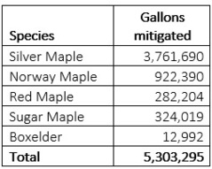 From the species population data, we observed a common over- planting of maple (Acer) species in the community. If the community were ever hit by the invasive Asian longhorned beetle (ALB) that prefers to feed on maple, Chesterton would be much worse off. Looking at the benefit analysis; maple as a genus makes up 66% of the stormwater benefit in Chesterton— approximately five million gallons annually. If we look more specifically, out of the five predominant species of maple in this community, silver maple provides just shy of four million gallons of benefit annually. Why? These are the large, very leafy and roughly barked trees that we love to hate right? All that leaf surface area and the species’ large size at maturity make it a posterchild for stormwater benefit.
Without the looming threat of an invasive forest pest like ALB; communities are strategically targeting the removal of this species because of its poor form, high rate of citizen complaints, and its propensity to be mature and in decline in urban plantings. What does that mean for Chesterton? They must start planting a more diverse selection of trees, prioritizing large-canopy trees, to build resilience. But are they? As they are removed, the community will be losing the benefits these silver maple trees provide. That is almost half of the stormwater benefits provided by the city trees! This statement does not include additional non-maple trees that will be lost to gray infrastructure maintenance, storms, age, and future development.
|
Preserve healthy large canopy trees forest patches and woodlots
 There is a great need to preserve existing tree cover and green space in our communities. This includes the strategic preservation of individual trees as well as overall reduction in land cover conversion and development.
All green space is not equal. While many can agree that a wooded lot or park provides more stormwater value over mown turf grass. The unfortunate fact is that most dry basins and floodways developed into parks are left as mown turfgrass with minimal tree canopy cover. The land area in communities mown that could be converted to tree cover can be quite large. That land includes land purchased as part of FEMA buyouts. A great example of where trees have been implemented in a FEMA buyout program is the Franklin Urban Forest in Franklin, IN, where native trees and seedlings were planted in the consolidated land that once housed a neighborhood.
Open green spaces like this may allow for species that are less acceptable for street tree planting application due to perceived “messiness” form, flowers or fruit deemed undesirable in high-traffic areas. Woodlots and parks need to be managed for species, as does age diversity. Using green spaces and street tree planting strategically will expand the resilience of a community’s urban forest.
|
 Bigger is Better
Often communities pride themselves on “great mitigation plans” making up for the loss of large canopy trees during development at 2:1 or 5:1 replacement ratios. The question remains is it really enough? Is it feasible to replant at these rates after development once buildings and associated paving are installed? Are all required trees planted on site or are we allowing variances? And, who is making sure these trees are still alive a year later, or in year 10, when the trees really start to provide big benefits?
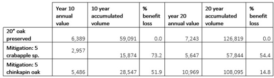
We can model a comparison of one scenario for stormwater benefits using i-Tree as an example. A 20-inch bur oak will be removed from a site to build a small chain restaurant, in return the community requires the chain to replant with five new trees of their choice (no requirement for large canopy tree species). If the chain plants five, 2-inch crabapple trees here is how it balances out. In year one, benefits lost from oak removal 5,541 gallons of stormwater mitigation. The five newly planted crabapples will provide 539 gallons of stormwater mitigation a deficit of more than 5,000 gallons. Had the site been required to plant five large canopy trees like 2-inch chinkapin oak, the benefit would be 921 gallons, a slightly smaller deficit. The difference in benefit really becomes apparent at year 10 and 20:
|
5 Points to Take Away
• Community trees are beautiful green stormwater infrastructure.
• There are modeling tools available to determine the value and benefit of trees, especially as stormwater infrastructure.
• Community trees need professional management, like all infrastructure, to provide the maximum benefit.
• Even under the ideal mitigation ratio of 5:1 replacement; species selection matters.
• Preservation of large healthy trees is in the best interest of all communities, especially those with stormwater challenges.
Resources
Arbor Day Foundation: Trees Tame Stormwater
Watershed Forestry Resource Guide
U.S. EPA Stormwater to Street Trees
Penn State Green Infrastructure webinar series
 Lowest Floor
By Darren Pearson, Division of Water
Floodplain administrators who review building plans and elevation certificates, as required for communities that participate in the National Flood Insurance Program (NFIP), must understand what is meant by “lowest floor.” The Indiana model floodplain ordinance defines lowest floor as:
Lowest floor means the lowest elevation described among the following:
(1) The top of the lowest level of the structure.
(2) The top of the basement floor.
(3) The top of the garage floor, if the garage is the lowest level of the structure.
(4) The top of the first floor of a structure elevated on pilings or pillars.
(5) The top of the floor level of any enclosure, other than a basement, below an elevated structure where the walls of the enclosure provide any resistance to the flow of flood waters unless:
- a) the walls are designed to automatically equalize the hydrostatic flood forces on the walls by allowing for the entry and exit of flood waters by providing a minimum of two openings (in addition to doorways and windows) in a minimum of two exterior walls; if a structure has more than one enclosed area, each shall have openings on exterior walls;
- b) the total net area of all openings shall be at least one (1) square inch for every one square foot of enclosed area; the bottom of all such openings shall be no higher than one (1) foot above the exterior grade or the interior grade immediately beneath each opening, whichever is higher; and,
- c) such enclosed space shall be usable solely for the parking of vehicles and building access.
Operation Stay Afloat 2018
Save the date! On March 13, the DNR Division of Water and the Indiana Department of Homeland Security will co-host the eighth biennial Operation Stay Afloat Conference in the Conference Center at the Indiana Government Center South Building, 402 W. Washington Street, Indianapolis. The conference is in the initial planning phase. This is a one-day conference you won’t want to miss. For more information contact Darren Pearson at dpearson@dnr.IN.gov.
CFM Exam Offering – March 27
By Darren Pearson, Division of Water
Are you ready to be Indiana’s next Certified Floodplain Manager (CFM)?
The DNR Division of Water will again proctor the CFM exam on Tuesday, March 27, at the Indiana Government Center South in Indianapolis (Conference Room 14) at 1 p.m. A short refresher session will be held in the same room from 8:30 a.m. until noon the same day.
To take the CFM exam, you must complete and submit the CFM Program Application Package to the Association of State Floodplain Managers (ASFPM). The forms are available on the ASFPM website, floods.org, under the Certification Program tab. The fee is $100 for ASFPM members and $450 for non-members.
You may submit an application for ASFPM membership at the same time you apply to take the exam. To be accepted to take the exam at this scheduled time, you must submit your completed application and pay the appropriate fee to ASFPM by March 13. No walk-ins will be allowed unless authorized by the ASFPM executive office. For specific information on the location and times, contact Darren Pearson at dpearson@dnr.IN.gov.
Indiana Training Opportunities – 2018
 (Information provided by FEMA)
Indiana Department of Homeland Security
Please visit the Indiana Department of Homeland Security’s training calendar for upcoming courses and trainings.
Association of State Floodplain Managers (ASFPM)
ASFPM has an online training program, and training is added regularly.
FEMA’s Emergency Management Institute (EMI)
E0176: Hazus-MH for Floodplain Managers. March 26-29, Emmitsburg, Md. This course provides in-depth instruction and hands-on activities that develop the skills needed by floodplain managers and emergency planners to effectively use Geographic Information Systems (GIS) tools, with emphasis on Hazus-MH, for modeling the impacts on communities from riverine and coastal flooding. Those who complete this course will understand the roles that floodplain managers support as well as how geospatial technologies such as Hazus-MH can be used to protect communities beyond the minimum standards that floodplain managers are responsible for implementing.
E0190: ArcGIS for Emergency Managers. April 2-5, Emmitsburg, Md. This course teaches new GIS users how to apply the ArcGIS for Desktop software to support disaster mitigation, response, recovery, and risk management. ArcGIS for Desktop allows users to analyze their data and create geographic knowledge to examine relationships, test predictions, and ultimately make better decisions. Course participants complete numerous hands-on activities that help them learn to develop informative maps as well as to use tools that answer questions based on where things are located and what is known about them. It also develops a variety of skills that can be used to create, edit, manage, and analyze both spatial and tabular data. While this course does not provide hands-on instruction specifically on Hazus-MH, all activities use Hazus-MH inventory and analysis outputs.
E0194: Advanced Floodplain Management Concepts. July 9-12, Emmitsburg, Md. This course provides a dynamic and interactive instruction that covers the following four topics in detail: Local Floodplain Manager Roles and Responsibilities, National Flood Insurance Program Floodplain Rules and Regulations in Depth, Letter of Map Change- Procedures for Applying and Floodplain Management Implications, and Preparing for Post-Disaster Responsibilities. Each topic is designed to be discussed and reviewed in greater detail than the basic course. Developed and real-life scenarios will be examined and activities will be conducted in each section to make sure participants not only understand the rules and regulations but also why they are in place and how to apply them in the particular topic areas. This course is activity-rich, and participants can expect to be engaged throughout.
E0273: Managing Floodplain Development through the NFIP. May 7-10, and Aug. 27-30, Emmitsburg, Md. This course provides an organized training opportunity for local officials responsible for administering their local floodplain management ordinance. The course will focus on the National Flood Insurance Program and concepts of floodplain management, maps and studies, ordinance administration, and the relationship between floodplain management and flood insurance.
E0278: NFIP/Community Rating System. March 26-29 and June 25-28. This course covers the Community Rating System (CRS), a nationwide initiative of FEMA’s National Flood Insurance Program (NFIP). It describes activities eligible for credit under the 2013 CRS Coordinator’s Manual, how a community applies, and how a community modifies an application to improve its classification.
E0282: Advanced Floodplain Management Concepts II. July 30-Aug. 2, Emmitsburg, Md. This advanced floodplain management course is a dynamic and interactive instruction that covers the following four topics in detail: Placement of Manufactured Homes and Recreational Vehicles in the Floodplain, National Flood Insurance Program Flood Insurance Principles for the Floodplain Manager, Higher Standards in Floodplain Management, and Hydrology and Hydraulics for the Floodplain Manager. Each topic is designed to be discussed and reviewed in greater detail than the basic course. Developed and real-life scenarios will be examined and activities will be conducted in each section to make sure participants not only understand the rules and regulations but also why they are in place and how to apply them in the particular topic areas. This course is activity-rich, and participants can expect to be engaged throughout.
E0284: Advanced Floodplain Management Concepts III. Feb. 5-8, Emmitsburg, Md. This advanced floodplain management course is a dynamic and interactive instruction that covers the following five topics in detail: Floodway Standards, Disconnects between National Flood Insurance Program Regulations and Insurance, Common Noncompliance Issues, Digital Flood Insurance Rate Maps (DFIRMs), and Substantial Improvement/ Substantial Damage. Each topic is designed to be discussed and reviewed in greater detail than the basic course. Developed and real-life scenarios will be examined and activities will be conducted in each section to make sure participants not only understand the rules and regulations but also why they are in place and how to apply them in the particular topic areas. This course is activity-rich, and participants can expect to be engaged throughout.
EMI also offers many more courses in Emmitsburg, around the country and through webinar training opportunities online. For additional information on EMI classes and webinars, please visit EMI’s training calendar website and its course catalog.
Other Trainings and Conferences
Association of State Floodplain Managers. June 17-21. Phoenix, AZ. The ASFPM annual conferences are recognized as the most important floodplain conference in the United States year after year. With more than 100 speakers and 1,200 participants, they are the national conferences all community, state and federal floodplain managers plan to attend. Please visit the ASFPM’s conference website for more information at http://www.asfpmconference.org/.
|
 |
|
2018 INAFSM CONFERENCE
By Darren Pearson, Division of Water
The Indiana Association for Floodplain and Stormwater Management will have its 22nd Annual Conference, Sept. 5-7, at the Old National Events Plaza in Evansville, IN. Mark your calendars. For more information about the INAFSM conference and the organization, visit inafsm.net.
|
 2017 INAFSM Conference
By Darren Pearson, Division of Water
The 21st annual Indiana Association for Floodplain and Stormwater Management (INAFSM) Annual Conference was held Sept. 6-8 at the Century Center in South Bend, overlooking the beautiful St. Joseph River. The theme was “Celebrating a Storm of Successes, Forecasting New Challenges.”
Roger Gage, recently retired floodplain administrator for the City of Decatur, received the Excellence in Floodplain Management Award. The Excellence in Stormwater Management Award went to Gavin Merriman, assistant stormwater superintendent for the Town of Zionsville.
The Outstanding Floodplain Project Award went to the Little River Wetlands Project for Eagle Marsh Nature Preserve Project (Project Owner: Natural Resources Conservation Service (NRCS), Indiana Department of Natural Resources, and Little River Wetland Project; Project Consultant: NRCS).
The Outstanding Stormwater Project Award went to the Symons-Krause Regulated Drain Watershed Project (Project Owners: Hamilton County Surveyor’s Office and Town of Sheridan; Project Consultant: Banning Engineering). The Scott County Area Plan Commission received the Excellent Strides in Floodplain Management Award.
The Chair’s Award for Outstanding Service in Support of INAFSM went to Karen Avery. The Education and Outreach Award went to Candi Donaldson, stormwater educator, Hendricks County Partnership for Water Quality.
Two Special Recognition Awards were presented. One went to Kent Ward for his many years of service as INAFSM legislative chair. The other was presented to Debbie Smith in recognition of her many years serving INAFSM in various leadership roles.
CONGRATULATIONS TO NEW CFMS
 By Darren Pearson, Division of Water
Six new Certified Floodplain Managers (CFMs) from Indiana were added to the list of the growing number of floodplain management professionals across the nation. The most recent additions are Zachariah Beasley (West Lafayette), James Butcher (West Lafayette), Chad Coughenour (Greenfield), Jeffery Fox (Fishers), Sam Ramsey (Marion), and Patrick Zaharako (Fort Wayne).
Two individuals from another state also passed the CFM Exam at one of the exam offerings in Indiana. They were James Moyer (Cincinnati) and Nicholas Tecca (Milwaukee).
This national program for professional certification of floodplain managers was established by the Association of State Floodplain Managers. The program recognizes continuing education and professional development that enhance the knowledge and performance of local, state, federal and private-sector floodplain managers. Congratulations!
|
2017 ASDSO National Dam Safety Conference Award Winners

The 2017 Association of State Dam Safety Officials (ASDSO) recognized a few individuals from Indiana for promoting dam safety during the 2017 ASDSO National Dam Safety Conference.
Ken Smith, assistant director of the Division of Water, Indiana Department of Natural Resources (DNR), was the first recipient of the Bruce A. Tschantz Public Safety at Dams Award. The Bruce A. Tschantz Public Safety at Dams Award recognizes and celebrates Bruce Tschantz’s lifetime achievements in dam safety, his contributions to ASDSO, and his efforts to improve public safety around dams. The award is given to a person who takes on the role of “local champion” and works to improve safety at dams. Ken has been a leader in low-head dam safety and awareness within DNR for several years.
|
 The Regional Award of Merit is annually given to individuals, companies, organizations, municipalities, or other entities working in the dam safety field that have made outstanding contributions to dam safety on a regional level. The Midwest Regional Award of Merit was awarded to Manuela Johnson, SDRF Program Manager, Indiana Department of Homeland Security, and Gary Johnson, Producer, WFYI Public Media for the documentary “Over, Under, Gone – The Killer in Our Rivers.”
Through the creation, airing and promotion of the documentary, Gary and Manuela have demonstrated concern for public safety education, volunteerism and the need for increased safety at dams. Through the documentary, they have strived to teach the state and region’s youth about waterway safety practices and the deceptive safety risks of low-head dams. The local community had a need for local education after deaths occurred at low-head dams. The documentary aired repeatedly in spring 2017 before the outdoor water activities season and was freely shared throughout the region. It has been a powerful tool in spreading awareness throughout the community. The message has also spread to other states and aided in awareness and proposed safety efforts in other communities. The documentary can be viewed here.
For more information on the Association of State Dam Safety Officials, go to https://damsafety.org/.
|
Recent Retirements
By Darren Pearson, Division of Water
Michael Neyer retired as director of the Division of Water this summer after working for the DNR for 43 years (19 as director). Debra Smith retired this summer after working for the state for 39 years (20 years as manager of the Floodplain Management Section). Laura Kannapel, northern water planner in the Floodplain Management Section, retired after 17 years with the Division of Water. We wish them all a happy and healthy retirement.
THANK YOU
Thanks to those contributing to this issue: Carrie Tauscher, Ryan Mueller, Marty Benson, Don Kaczorowski, George Bowman, Anita Nance, and Ed Reynolds.
Editor – Darren Pearson
The work that provides the basis for this newsletter was supported by funding under a cooperative agreement with the Federal Emergency Management Agency. The author and publisher are solely responsible for the accuracy of the statements and interpretations contained in the publication. Such interpretations do not necessarily reflect the views of the federal government.
Waterlines is produced biannually as a public service by the DNR Division of Water.
Waterlines is available on the web at dnr.IN.gov/water.
Having trouble viewing this email? View it as a Web page.
|