|
WATERLINES GOES DIGITAL
Waterlines is now a digital publication. Due to increased costs, the Division of Water is unable to continue printing it and mailing it. A few months ago, via return postcard, we asked recipients how they would like to access future Waterlines. Most chose email. Please contact our office if your email address changes. You may also view Waterlines on our website.
THORGREN BASIN – CHANGE IS GOOD: BOTH FOR FLOOD CONTROL AND THE ENVIRONMENT
Information provided by FEMA
The Thorgren Basin in the City of Valparaiso has recently been retrofitted from a polluted and unattractive flood-detention facility to a landscaped and environmentally responsible part of the city’s green infrastructure.
Primary construction of the Thorgren Basin retrofits was completed in November 2012 with other environmental enhancements added more recently. The main goal of the rebuild was to better capture the contaminants found in the runoff from nearby properties, roads and industrial sites in the basin’s watershed. In place of the concrete that once lined the straight drainage channels of the dry basin are bio-swales with native vegetation, clay-lined permanent pools, transitional wetland zones and upland infiltration areas. The changes also included new landscaping that now provides varied topography for wildlife habitats. In addition, native vegetation was planted throughout the basin to naturalize its hydrology. Due to these changes, a small amount of water is an intentional, permanent presence on the site.
Much of the work for the rehabilitation of the basin was funded with a grant from the Great Lakes Restoration Initiative. In cooperation with that initiative, the $815,000 cost of the project was also funded by the Environmental Protection Agency, Save the Dunes Council and the City of Valparaiso.
While not designed to contain a 100-year rain event, the overall capacity of the basin was increased by 60% with the removal of 24,000 cubic yards of soil. Additional construction to the basin’s infrastructure (culverts, etc.) is also planned in order to reduce the amount of overland flow of water to the basin.
As explained by Healing Our Waters-Great Lakes Coalition, these retrofits are expected to prevent 402 pounds of nitrogen, 130 pounds of phosphorus and 23 tons of sediment from entering the watershed every year.
The 2-acre slope-sided, grassy basin was put into place to collect rainwater from about 330 acres of mostly commercial, industrial and residential properties in the city. After rain or melting snow, the water contained in the basin is directed to the Salt Creek watershed and eventually into Lake Michigan. Originally, the facility was not designed to mitigate or contain any of the contaminants that might have found their way into the basin and local waterways.
While the basin’s primary purpose was (and remains) flood control, it was envisioned that the area could be more than simply a holding tank for excess stormwater. Furthermore, it was believed that the basin could become an important local element in the effort to keep chemicals, debris, wastes and other solids out of Lake Michigan. Undesirable “extras” in urban/suburban runoff can contain such items as sediment; bacteria from pet wastes and septic systems; lawn chemicals from fertilizers and pesticides; and oil, trash and salt from roads, parking lots and other nearby hard surfaces.
Incredibly, what was formerly thought of as a necessary, but unpleasant public utility is now the destination of students learning about the restorative effects of the basin. As reported by a local newspaper, around Earth Day in late April 2014, about 70 children explored the basin, planted trees, took water samples and searched for insects and other small animals within the area.
The Thorgren Basin reconstruction is a great example of how something as humble as a water- detention basin can become an asset to both the local community and the larger watershed.
A photo of the completed basin is shown below. To view a series of photographs highlighting the newly redesigned basin, please visit the Northwest Indiana Regional Development Authority’s Thorgren Basin webpage.
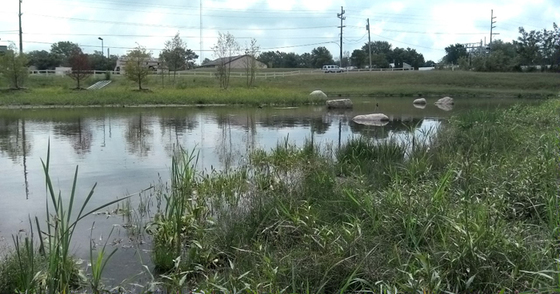 Thorgren Basin after the reconstruction project. (Photo: Thorgren Basin webpage)
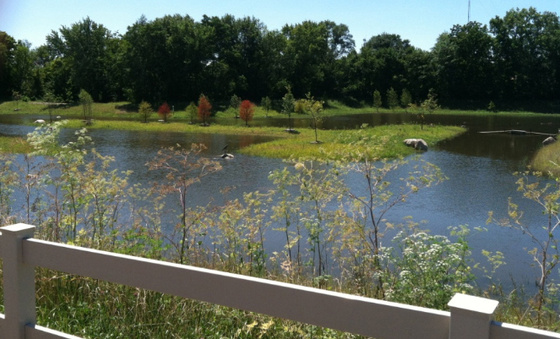 The project to expand and restore Thorgren Basin after heavy rains. It is seen teeming with waterfowl, including (if you look closely) a heron perched on the rock just to the left of center. (Photo:Thorgren Basin webpage)
 THANKS FOR THE MEMORIES – GREG MAIN, NFIP COORDINATOR
Floodplain Management Section, DNR
Indiana lost one of its treasures when Greg “Buckshot” Main passed away at home on Oct. 22, 2015, after a long struggle with an illness. Greg worked for the Indiana DNR for almost 30 years, serving as state coordinator for the National Flood Insurance Program (NFIP) since 1997. Words cannot express the amount of knowledge, wisdom and life lessons Greg imparted to his Division of Water co-workers.
His floodplain-management co-workers will never forget their many trips to the field to tour floodplains. Any trip to the field with Greg meant a mandatory stop at McDonalds so he could get his morning coffee. Chances were it was McDonalds for lunch, too. Greg was adept at pointing out a rafter of turkeys or a few deer in a field while driving around hairpin turns with ravines on either side of the road. Fingernail marks are still in many armrests.
Saying that Greg loved the outdoors and wildlife is an understatement. Every trout season, Greg could be found at his favorite fishing hole with his dad and sons, each catching their limit. He would hunt for deer and turkey every year. Greg would always laugh every Monday morning each fall when he was asked if he caught any deer over the weekend. His response was always, “No, I didn’t catch any deer, but I shot a few and they are hanging in my garage.”
Greg’s sense of humor will be missed. We all benefitted from his frequent trips into the woods in the form of venison jerky and some of the best and most unusual chili ever made.
“Buckshot” got his nickname in the aftermath of one of the infamous Division of Water chili contests, for which Greg made his usual unusual entry. The unusual chili that year consisted of venison and some beaver meat that Greg traded for with a fellow hunter. Greg thought he removed all of the buckshot from the meat. Apparently he missed some. No dental work was required, and Greg whipped his co-workers in the chili contest yet again.
Greg loved his job. He was at his best when attending the Flood Risk Open Houses and wading through Indiana’s map-modernization process. Greg talked flood insurance with the best of them. He had a way of disarming the most upset property owners while making sure they understood their flood-insurance implications. Whether it was for flood risk open houses, phone calls in the office, community visits, workshops, or Capitol Hill, Greg proudly claimed his “just an Indiana farm boy” roots and easily engaged with people from all walks of life. He generally had a calming effect on people by looking for common ground and represented Indiana well at both the State and national level.
Greg was a founding member of the Indiana Association for Floodplain and Stormwater Management and actively served the organization since its formation. Greg also served on the Board of Directors of the Association of State Floodplain Managers. He was a Certified Floodplain Manager. Greg was an advocate for No Adverse Impact and adopting higher floodplain-management regulations. One of the many quotes that Greg loved to use in presentations was credited to Albert Einstein: “The definition of insanity is doing the same thing over and over again, but expecting different results.” All who knew him should endeavor to continue Greg’s legacy by continuing his efforts to improve and advance floodplain management in Indiana.
Get out and enjoy the outdoors or have a bowl of chili. When you do, remember Greg, a mentor to many and friend to all.
|
RISK MAP FALL 2015 UPDATE - INDIANA
FEMA’s national Risk Mapping, Assessment, and Planning (Risk MAP) program is intended to result in local activities that reduce risk. In 2014, in partnership with the state of Indiana, FEMA Region V started efforts designed to engage selected communities in discussions about local risk- reduction activities that result in safer communities. Since then, FEMA Region V and State representatives have been meeting with community officials, mitigation consultants, and regional stakeholders to define desired local mitigation-activity implementation steps, challenges and needed technical support. This effort enhanced existing mitigation-planning efforts by identifying federal and State tools, resources and technical assistance that may spur progress on local risk-reducing mitigation activities.
In Indiana, FEMA, the Indiana Department of Natural Resources, the Indiana Department of Homeland Security, and the Polis Center have been working with STARR, FEMA’s consultant, to discuss risk-reducing options with Indiana communities. Through this partnership, mitigation technical assistance needs have been documented for future funding considerations and to inform local planning efforts. In addition, some communities are receiving technical assistance to support local risk-reduction efforts.
The City of Columbus was supported on its efforts to keep critical facilities and hazardous materials away from flooding and increase awareness on disaster response and preparedness. The Town of Brooklyn is mitigating roadway overtopping risk supported with technical culvert and risk data. Participating communities in Morgan County were guided on how to better regulate risk from fluvial erosion. Both Morgan County and the City of Martinsville will use detailed flood-risk data to support acquisition projects. Participating communities in Floyd, Harrison, Orange and Washington counties received depth grids that provide flood depths for a variety of flood frequencies that will support local acquisition projects; bolster road overtopping mitigation, local risk assessment and risk reducing regulations; and help guide smart development that maintains public safety.
Harrison County also received inundation maps related to an Ohio River gage to support awareness, smart development and emergency action. Jackson County will be provided an impact analysis to support road overtopping solutions as well as depth grids to supplement its Hazard Mitigation Plan, and the City of Noblesville is working on a plan to potentially mitigate road overtopping and safely expand its wastewater treatment plan through using risk data to identify smart expansion ideas.
Also, phased discovery is nearing completion for 20 communities in the St. Joseph Watershed, where mapping and mitigation technical assistance needs have been documented for future funding considerations and to inform local planning efforts.
Over the winter, the program will wrap up efforts to support communities with local mitigation needs. FEMA and the state will be considering additional technical assistance support and other efforts to help communities take action to reduce flood risk.
If you have any questions about the program, please contact any of the following project partners:
David Knipe, IN DNR, at dknipe@dnr.IN.gov
Mary Moran, IN DHS, at mmoran@dhs.IN.gov
Tom Smith, FEMA RV, at thomas.smith6@fema.dhs.gov
Emily Whitehead, STARR, at emily.whitehead@stantec.com
CFM EXAM OFFERING – MARCH 29
Are you ready to be Indiana’s next Certified Floodplain Manager (CFM)?
The DNR Division of Water will again proctor the CFM exam on Tuesday, March 29, at the Indiana Government Center South in Indianapolis (Conference Room 14) at 1 p.m. A short refresher session will be held from 8:30 a.m. until noon the same day. The refresher session will also be held in Conference Room 14.
In order to take the CFM exam you must complete and submit the CFM Program Application Package to the Association of State Floodplain Managers (ASFPM). The forms are available on the ASFPM website and at floods.org, as well as under the Certification Program tab. The fee for taking the exam is $100 for ASFPM members and $450 for non-members.
You may submit an application for ASFPM membership at the same time you apply to take the CFM exam. To be accepted to take the CFM exam at this scheduled time, you must submit your completed application along with the appropriate fee to ASFPM by March 14 (approximately 2 weeks before the exam date). No walk-ins will be allowed unless authorized by the ASFPM executive office. For specific information on the location and times, contact Anita Nance at anance@dnr.IN.gov.
 MORE CONGRATULATIONS ARE IN ORDER
Indiana passed the century mark and now has 113 Certified Floodplain Managers (CFMs). The most recent additions are Darren Pearson, DNR Division of Water; Amanda Budreau of Lawson-Fisher and Associates; Brandon Sanders and Rudy Vugteveen, both of RMA Surveying; Bryan Grotz of HWC Engineering; and Kim Hostetler of Huntington County. All six CFMs successfully completed the exam in September. Congratulations to Darren, Amanda, Brandon, Rudy, Bryan, and Kim.
This national program for professional certification of floodplain managers was established by the Association of State Floodplain Managers. The program recognizes continuing education and professional development that enhance the knowledge and performance of local, state, federal and private-sector floodplain managers.
|
CONFERENCE CORNER
OPERATION STAY AFLOAT 2016
The Indiana DNR and the Indiana Department of Homeland Security (IDHS) will present Operation Stay Afloat again this year. The conference is on Tuesday, March 15, from 8:30 a.m. to 5 p.m., in the Indiana Government Center Conference Center. The day will be full of interesting, pertinent information on floodplain issues and mitigation.
No registration fees will be charged; however, participants are responsible for their own lunch and any parking expenses. Space is limited. Please register in advance. For more information, contact Anita Nance, Floodplain Management Section of the DNR Division of Water, at either (317) 234-1110 or anance@dnr.IN.gov.
 2015 INAFSM CONFERENCE
The 2015 Indiana Association for Floodplain and Stormwater Management (INAFSM) Annual Conference was held on Sept. 9-11 at Potawatomi Inn in Pokagon State Park, near Angola. The conference was educational, entertaining, and topical. Several awards were presented.
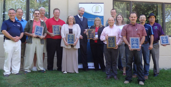
Toni Cecil, construction compliance inspector for the Muncie Sanitary District Stormwater Department, was awarded the Excellence in Stormwater Management Award. The Outstanding Stormwater Management Award went to Durkees Run Stormwater Park. The Wells County CRS Program was presented the Excellence in Floodplain Management Award. The Outstanding Floodplain Project Award went to the Hamilton County Surveyor’s Sand Creek/Cumberland Road Project. The City of Jeffersonville Floodplain Management Program received the Excellent Strides in Floodplain Management Award. The Chairman’s Award for Outstanding Service in Support of the INAFSM went to Kenny Hale.
Two Special Recognition Awards were presented. One of the awards went to Greg Main to recognize his many years of service at DNR Division of Water, as well as his years of service in INAFSM and as past-chair for ASFPM. The other was presented to Zach Beasley in recognition of his leadership.
2016 INAFSM CONFERENCE
2016 will mark the 20th anniversary of INAFSM. This will be a special year of celebration for the association. The 2016 INAFSM Conference will be held at the Beltera Conference Center in Florence, IN, Sept. 7-9. Mark your calendars. For more information about the INAFSM conference and the organization, visit inafsm.org.
DAMS IN INDIANA – WHAT YOU REALLY NEED TO UNDERSTAND
Ken Smith, DNR
Dam-hazard classification indicates the potential consequences to downstream areas posed by a dam failure; it is not an assessment of the physical condition of the dam. A high-hazard dam classification means that if a dam were to fail, there would likely be loss of life, homes at risk, and substantial property damage downstream. The hazard classification does not indicate the presence or lack of dam-safety deficiencies. Of the 85,000 dams in the United States, there are currently about 14,000 dams classified as high hazard. Of the 1,100 state-regulated dams in Indiana, approximately 250 are classified as high hazard. In the U.S. and in Indiana, about 70% of these dams are privately owned.
Dam failures are often preventable disasters. Advance planning is essential for preventing dam failures and resulting damages. A dam Incident and Emergency Action Plan (IEAP) allows for such planning with the dam owner, their private engineers and local emergency officials. IEAPs typically contain dam- failure flood-inundation maps, detailed written information for evaluating the seriousness of multiple-level events, notification and communication procedures, and pre-planned actions and responsibility statements for carrying out the IEAP.
Indiana, as well as about half of the other states in the nation, does not have a statutory requirement that dam owners produce an IEAP. In 2008, therefore, few IEAPs for dams existed in Indiana.
Today, through very limited grant funding that was received and partnerships between many stakeholders, including public and private high-hazard dam owners, progress has been made in the development of IEAPs for other non-State owned dams. An innovative, county-focused multi-dam IEAP tabletop exercise devised by Indiana was recently tested in Morgan and Bartholomew counties. This multi-dam pilot project is an Indiana Silver Jackets cooperative effort between the DNR Dam Safety Section, the Department of Homeland Security, and the Indiana Office of Community & Rural Affairs. This new approach that addresses multiple dams potentially affecting an individual county was created to achieve substantially wider community dam-safety preparedness, outreach and training than traditional single-dam safety exercises conducted in the past.
In the future, dam-safety stakeholders will continue to seek the reduction of flood damage caused by dams. To accomplish this, it will be important to be prepared to respond to slowly developing dam- safety incidents before they progress and become much-worse, rapidly developing emergencies. Because of the success of this innovative IEAP pilot project, the initial partners in this initiative will continue to seek other opportunities and partners to further apply this new county-focused approach elsewhere in the state.
While the innovative grant-funded initiative continues, many dams still do not have IEAPs and likely won’t for many years. Many downstream stakeholders remain uninformed about dam-failure risk at their homes and property. The e-booklet “Living with Dams: Know Your Risks,” prepared by the Association of State Dam Safety Officials (ASDSO), provides a great deal of additional information and can be found at http://livingneardams.org/.
Having trouble viewing this email? View it as a Web page.
|