FOR IMMEDIATE RELEASE: Sept. 2, 2014
MANGROVE RESTORATION STUDY UNDERWAY IN ROOKERY BAY RESERVE
~
Research partnership with USGS will assess natural community’s response to
restoration efforts ~
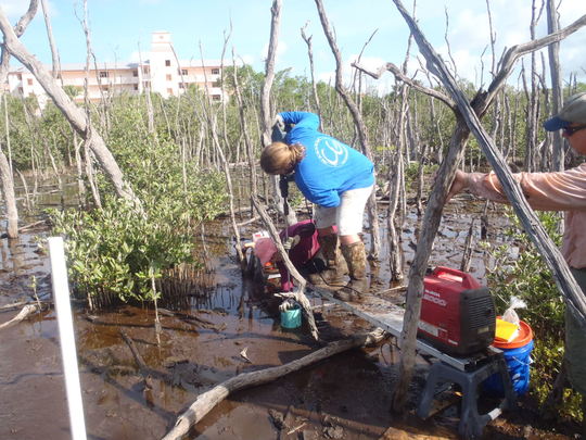 Nicole Cormier (left), an ecologist with the U.S. Geological Survey’s National Wetlands Research Center in Lafayette, Louisiana, holds a stainless steel rod in place while it is being driven into the sediment at Fruit Farm Creek near Goodland.
NAPLES – Rookery Bay National Estuarine Research Reserve has entered into a research partnership with the U.S. Geological Survey (USGS) to conduct a long-term study of a mangrove die-off area near Goodland. USGS awarded funding to this project for a minimum of three years to assess the 225-acre hydrologic restoration, partially underway, at Fruit Farm Creek.
Fruit Farm Creek is a mangrove-forested site located within the boundaries of the Rookery Bay Reserve, near Goodland on the Southwest Gulf coast of Florida. Construction of State Road 92, initiated in 1938, greatly altered natural tidal flushing to mangrove wetlands in the area. In particular, incoming flow from higher tides inundates the forest but cannot readily be flushed out, creating a “bathtub effect” that holds the water for longer periods than these forests would normally experience. Summer rains compound this effect. Following the heavy, flooding rains from Hurricane Andrew in 1992, the area has experienced a slow, steady die-off of approximately 65 acres of mangroves.
The reserve has partnered with the Coastal Resources Group, the U.S. Fish and Wildlife Service, the Conservancy of Southwest Florida and the city of Marco Island to conduct the initial assessment of the area’s hydrology and produce a plan for restoring the affected mangrove forests.
“We have examples of how hydrological restoration works in other locations,” said Kevin Cunniff, research coordinator for Rookery Bay Reserve. “A long-term assessment of forest community change and recovery over the next decade will provide invaluable information regarding the resiliency of our mangrove wetlands and the cost/benefits of restoration.”
USGS has just installed 12 Rod Surface Elevation Tables (RSETs) in order to monitor surface elevation change associated with mangrove forest recovery within the study plots, which span a gradient of dead, degraded and intact forest. Initial assessments of the forest canopy, sediment conditions and plant/animal communities will begin early in 2015. Three reference area study plots, also including RSETs, will be established on the south end of Horrs Island adjacent to Fruit Farm Creek in November 2014. Long-term data collected will provide information on trends in forest canopy structure, sediment chemistry and nutrient cycling, and benthic faunal community and food-web structure.
In August 2013, a series of small trenches were excavated to re-establish tidal connection to one acre of a four-acre die-off area. Within one year, the return of normal tidal flushing has produced a dramatic response — mangrove seedlings are taking root and many of the characteristic fish, crabs, snails and other species have moved in. The project partners are still seeking additional funding to restore flushing to the remaining 224 adjacent acres. It is on the list of projects under consideration for federal funding through the Resources and Ecosystems Sustainability, Tourist Opportunities, and Revived Economies of the Gulf Coast Act (RESTORE Act).
|