Hillsborough County's New Pedestrian Trail Bridge
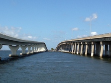 Nov 16 marked the official opening of the Courtney Campbell Causeway Scenic Trail. A ribbon-cutting ceremony sponsored by the Courtney Campbell Scenic Highway Corridor Advisory Committee was held to celebrate and debut Hillsborough County’s segment of the new multi-use pedestrian trail and bridge.
The span, constructed by the American Bridge Company was funded using federal dollars allotted by the Florida Department of Transportation (DOT). The bridge runs parallel to existing State Road 60 and connects with the existing U-Path trail on the east, which links Skyway Park and Cypress Point Park. It continues west to Ben T. Davis Beach and currently ends at the Hillsborough/Pinellas County line.
The ribbon cutting ceremony had been a highly anticipated event, even though DOT allowed users access to the Hillsborough County portion of trail beginning Labor Day weekend. Bill Jonson, Chair of the Courtney Campbell Scenic Highway Corridor Advisory Committee, said: “Usage of the trail has exceeded my expectations especially since the trail is open only half way across the causeway. There are many people out there all the time – a real asset to the Tampa Bay area.”
Phase two, the Pinellas County three-mile segment, is scheduled to begin construction in January and is projected to finish in early 2015. When complete, the Courtney Campbell Trail will offer trail users nine miles of continued connectivity. “We are excited to be behind this project," states DOT, District Seven Public Involvement Coordinator, Lori Marable, "it’s a great asset to the regional trail connections in our area.”
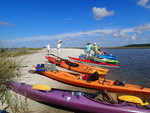
The causeway, which features a 45 foot overlook, offers picturesque vistas of the Tampa Bay, St. Petersburg and Clearwater tri-city area. It also offers a 12-foot wide path that welcomes bird-watchers, walkers, runners, in-line skaters and bicyclists. For the safety of all users, anglers are required to fish under and alongside the bridge’s entry points, but not on the bridge itself.
If you did not have the opportunity to attend the opening ceremonies, now is the perfect time to get outdoors, enjoy the cooler weather and discover the new multi-use pedestrian trail bridge.
|
St. Johns River, Cypress Creek Receive Council Approval
The Florida Greenways and Trails Council (FGTC) voted unanimously to approve designations of the Cypress Creek Natural Area and the St. Johns River Blueway paddling tail into the Florida Greenways and Trails System at its Sept 27 meeting in Sanford, Florida.
The 2,083-acre Cypress Creek Natural Area (CCNA) helps to protect the wild and scenic Loxahatchee River and its high-quality examples of basin marsh, blackwater stream, depression marsh, dome swamp, hydric hammock, mesic flatwoods, mesic hammock, scrubby flatwoods, strand swamp and wet flatwoods. It is managed by the Palm Beach County Environmental Lands Division.
The CCNA also contains a portion of the Loxahatchee River Battlefield from the Second Seminole War, remnants of the Rood Settlement, Native American middens and a segment of the historic Jupiter-Indiantown Road, making this designation an extremely important environmental and cultural inclusion.
Proposed and existing recreational facilities and interpretive features at the CCNA include a series of hiking and multi-use trails, a canoe/kayak launch and trail, a fishing pier and other public use facilities. Visit the Cypress Creek Natural Area website for detailed information about the property and its offerings.
In 2003, public and private partners from 13 counties collaborated to form the St. Johns River Alliance, a non-profit group with a goal of “preserving, protecting, and promoting America’s first river.” The Alliance rallied behind and requested the designation of the St. Johns River Blueway.
The 310-mile Blueway stretching from Brevard to Duval County was also fully implemented into the network, becoming the longest river trail to be designated. Maps and trail guides are currently being developed by the Alliance. To learn more about this mighty river, its tributaries or its adjacent land parcels visit the St. Johns River Alliance’s website.
To obtain information on the Office of Greenways and Trails Designation Program, visit the website or contact Marsha Rickman at marsha.rickman@dep.state.fl.us.
Local Trail Extension Projects Established through DOT Partnership
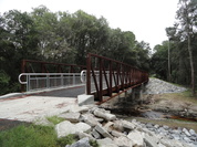 The Florida Department of Transportation (DOT) has been a partner in the construction of trails in past years. Two of the latest projects to conclude are sections of the Archer Braid Trail and the Palatka-to-Lake Butler State Trail (PLBST).
The newest segment of the Archer Braid Trail, completed this June, was built along Archer Road (State Road 24) from the water tower in Archer to Southwest 91st Street in Gainesville.
In addition to the paved six-mile, 10-foot wide trail, a trailhead located at the western end of the route was also constructed. Parking is available at the trailhead and a water fountain was added by the Archer Chamber of Commerce.
Another expansion project unveiled by DOT last month is the newest section of the Palatka-to-Lake Butler State Trail, which runs alongside State Road 100 from Holloway Road to Roberts Lane. With this project complete, the PLBST now provides 19 miles of continuous paved trail that reaches through and connects Bradford, Clay and Putnam counties.
As DOT continues their commitment to trails, plans are in DOT’s Five-Year Work Program to fund more paths along the Archer Braid Trail footprint and expand further down State Roads 100 and 207.
The creation and use of these facilities and others like it throughout Florida further enhance the state’s roadways.The trails provide ways for users to safely move about for recreation. They improve the overall health of users and aid in getting users from one place to the next.
By Laurie Windham and Laurie Sanderson
|
|